
File:National 113th Congressional District Wall Map.pdf

此 PDF 檔案的 JPG 預覽的大小:800 × 593 像素。 其他解析度:320 × 237 像素 | 640 × 475 像素 | 1,024 × 759 像素 | 1,280 × 949 像素 | 2,560 × 1,898 像素 | 6,675 × 4,950 像素。
原始檔案 (6,675 × 4,950 像素,檔案大小:16.68 MB,MIME 類型:application/pdf)
摘要
| 描述 |
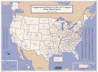
English: Census Bureau map of Congressional Districts in the 113th Congress including 50 states, DC and five territories |
| 日期 | |
| 來源 | https://www.census.gov/geo/maps-data/maps/cd113_us_wallmap.html |
| 作者 | U.S. Census Bureau |
授權條款
This image or file is a work of a United States Census Bureau employee, taken or made as part of that person's official duties. As a work of the U.S. federal government, the image is in the public domain.
|
 |
檔案歷史
點選日期/時間以檢視該時間的檔案版本。
| 日期/時間 | 縮圖 | 尺寸 | 使用者 | 備註 | |
|---|---|---|---|---|---|
| 目前 | 2015年8月21日 (五) 08:40 |  | 6,675 × 4,950(16.68 MB) | TheVirginiaHistorian | User created page with UploadWizard |
檔案用途
下列2個頁面有用到此檔案:
全域檔案使用狀況
以下其他 wiki 使用了這個檔案:
- en.wikipedia.org 的使用狀況
- it.wikipedia.org 的使用狀況
- simple.wikipedia.org 的使用狀況