
File:Earth dry elevation.stl
此STL文件的PNG预览的大小:800 × 600像素。 其他分辨率:320 × 240像素 | 640 × 480像素 | 1,024 × 768像素 | 1,280 × 960像素 | 2,560 × 1,920像素 | 5,120 × 3,840像素。
原始文件 (5,120 × 2,880像素,文件大小:27.66 MB,MIME类型:application/sla)
View Earth dry elevation.stl on viewstl.com
摘要
| 描述 |
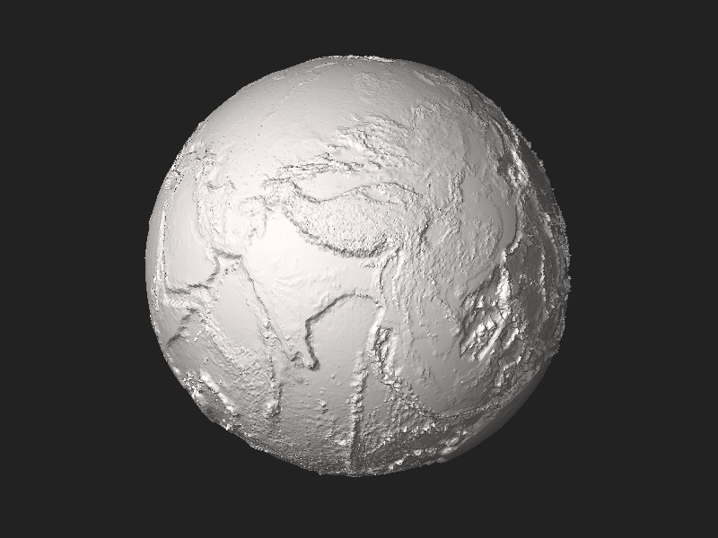
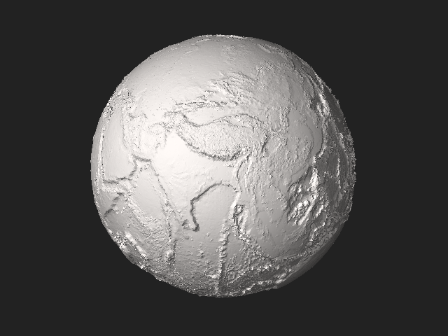
English: Earth without liquid water greatly exaggerated elevation model by CMG Lee using depthmap File:Earth_dry_elevation.png generated from NASA Visible Earth topography and bathymetry data. |
|||
| 日期 | ||||
| 来源 | 自己的作品 | |||
| 作者 | Cmglee | |||
| 其他版本 |
|


Python source
#!/usr/bin/env python

exaggeration   = 10
header         = ('Dry Earth %s-times-exaggerated elevation model by CMG Lee using NASA data.'
                  % (exaggeration))
path_png_alt   = 'earth_dry_elevation.png' ## 1-channel equirectangular PNG
luma_datum     = 141                       ## image intensity level (of 0-255) of datum
radius_datum   = 6378.137                  ## mean radius of zero level in km
f_wgs84        = 1 / 298.257223563         ## WGS84 flattening factor
km_per_luma    = (10.994 + 8.848) / 255 * exaggeration ## min and max elevations in km
scale          = 1e-2                      ## overall scale of model in km^-1
lat_offset     = 5.0 / 8                   ## rotation around planet axis in revolutions
n_division     = 200                       ## each cubic face divided into n_division^2 squares

class Png:
 def __init__(self, path):
  (self.width, self.height, self.pixels, self.metadatas) = png.Reader(path).read_flat()
 def __str__(self): return str((self.width, self.height, len(self.pixels), self.metadatas))

import time, re, math, struct, png
time.start = time.time()
def log(string): print('%6.3fs\t%s' % (time.time() - time.start, string))
def fmt(string): ## string.format(**vars()) using tags {expression!format} by CMG Lee
 def f(tag): i_sep = tag.rfind('!'); return (re.sub('\.0+$', '', str(eval(tag[1:-1])))
  if (i_sep < 0) else ('{:%s}' % tag[i_sep + 1:-1]).format(eval(tag[1:i_sep])))
 return (re.sub(r'(?<!{){[^{}]+}', lambda m:f(m.group()), string)
         .replace('{{', '{').replace('}}', '}'))
def append(obj, string): return obj.append(fmt(string))
def tabbify(cellss, separator='|'):
 cellpadss = [list(rows) + [''] * (len(max(cellss, key=len)) - len(rows)) for rows in cellss]
 fmts = ['%%%ds' % (max([len(str(cell)) for cell in cols])) for cols in zip(*cellpadss)]
 return '\n'.join([separator.join(fmts) % tuple(rows) for rows in cellpadss])
def hex_rgb(colour): ## convert [#]RGB to #RRGGBB and [#]RRGGBB to #RRGGBB
 return '#%s' % (colour if len(colour) > 4 else ''.join([c * 2 for c in colour])).lstrip('#')
def viscam_colour(colour):
 colour_hex      = hex_rgb(colour)
 colour_top5bits = [int(colour_hex[i:i+2], 16) >> 3 for i in range(1,7,2)]
 return (1 << 15) + (colour_top5bits[0] << 10) + (colour_top5bits[1] << 5) + colour_top5bits[2]
def roundm(x, multiple=1):
 if   (isinstance(x, tuple)): return tuple(roundm(list(x), multiple))
 elif (isinstance(x, list )): return [roundm(x_i, multiple) for x_i in x]
 else: return int(math.floor(float(x) / multiple + 0.5)) * multiple
def average(xs): return None if (len(xs) == 0) else float(sum(xs)) / len(xs)
def flatten(lss): return [l for ls in lss for l in ls]
def rotate(facetss, degs): ## around x then y then z axes
 (deg_x,deg_y,deg_z) = degs
 (sin_x,cos_x) = (math.sin(math.radians(deg_x)), math.cos(math.radians(deg_x)))
 (sin_y,cos_y) = (math.sin(math.radians(deg_y)), math.cos(math.radians(deg_y)))
 (sin_z,cos_z) = (math.sin(math.radians(deg_z)), math.cos(math.radians(deg_z)))
 facet_rotatess = []
 for facets in facetss:
  facet_rotates = []
  for i_point in range(4):
   (x,y,z) = [facets[3 * i_point + i_xyz] for i_xyz in range(3)]
   if (x is None or y is None or z is None): facet_rotates += [x,y,z]

   else:
    (y,z) = (y * cos_x - z * sin_x, y * sin_x + z * cos_x) ## rotate about x
    (x,z) = (x * cos_y + z * sin_y,-x * sin_y + z * cos_y) ## rotate about y
    (x,y) = (x * cos_z - y * sin_z, x * sin_z + y * cos_z) ## rotate about z
    facet_rotates += [round(value, 9) for value in [x,y,z]]
  facet_rotatess.append(facet_rotates)
 return facet_rotatess
def translate(facetss, ds): ## ds = (dx,dy,dz)
 return [facets[:3] + [facets[3 * i_point + i_xyz] + ds[i_xyz]
                       for i_point in range(1,4) for i_xyz in range(3)]  for facets in facetss]
def flip(facetss): return [facets[:3]+facets[6:9]+facets[3:6]+facets[9:] for facets in facetss]

def cube_xyz_to_sphere_xyz(cube_xyzs):
 (x,y,z)                         = [float(xyz) for xyz in cube_xyzs]
 (x_squared,y_squared,z_squared) = (x * x,y * y,z * z)
 return (x * (1 - (y_squared + z_squared) / 2 + y_squared * z_squared / 3) ** 0.5,
         y * (1 - (x_squared + z_squared) / 2 + x_squared * z_squared / 3) ** 0.5,
         z * (1 - (y_squared + x_squared) / 2 + y_squared * x_squared / 3) ** 0.5)
def xyz_to_lla(xyzs):
 (x,y,z) = xyzs
 alt     = (x * x + y * y + z * z) ** 0.5
 lon     = math.atan2(y, x)
 lat     = math.asin(z / alt)
 return (lat,lon,alt)
deg_90 = math.pi / 2
def find_alt(lat_lons, altss):
  (lat,lon) = lat_lons
  if   (lat ==  deg_90): alt = average(altss[ 0])
  elif (lat == -deg_90): alt = average(altss[-1])
  else:
   (width,height) = (len(altss[0]),len(altss))
   x              = (0.5 + lon / (deg_90 * 4) + lat_offset) * width
   y              = (0.5 - lat / (deg_90 * 2)             ) * height
   (x_int,y_int)  = (int(x)   , int(y)   )
   (x_dec,y_dec)  = (x - x_int, y - y_int)
   (x0,x1)        = (x_int % width , (x_int + 1) % width )
   (y0,y1)        = (y_int % height, (y_int + 1) % height)
   alt            = ((altss[y0][x0] * (1 - x_dec) + altss[y1][x0] * x_dec) * (1 - y_dec) +
                     (altss[y0][x1] * (1 - x_dec) + altss[y1][x1] * x_dec) *      y_dec)
  # print(map(math.degrees, lat_lons), y,x, alt)
  return alt
def radius_wgs84(lat):
 if (lat in radius_wgs84.cachess): return radius_wgs84.cachess[lat]
 (sin_lat, cos_lat)        = (math.sin(lat), math.cos(lat))
 ff                        = (1 - f_wgs84) ** 2
 c                         = 1 / (cos_lat ** 2 + ff * sin_lat ** 2) ** 0.5
 s                         = c * ff
 radius_c_s_s              = (radius_datum * c, radius_datum * s)
 radius_wgs84.cachess[lat] = radius_c_s_s
 return radius_c_s_s
radius_wgs84.cachess = {}
def lla_to_sphere_xyz(llas):
 (lat,lon,alt)        = llas
 (sin_lat,sin_lon)    = (math.sin(lat),math.sin(lon))
 (cos_lat,cos_lon)    = (math.cos(lat),math.cos(lon))
 (radius_c, radius_s) = [(c_s_radius + alt * km_per_luma) * scale
                         for c_s_radius in radius_wgs84(lat)]
 return (radius_c * cos_lat * cos_lon,radius_c * cos_lat * sin_lon,radius_s * sin_lat)
def xyz_alt_to_xyza(xyzs, altss):
 (lat,lon,alt) = xyz_to_lla(xyzs)
 alt           = find_alt((lat,lon), altss)
 lla_alts      = [list(lla_to_sphere_xyz((lat,lon,alt))), alt]
 return lla_alts

log("Read elevation data")
png_alt = Png(path_png_alt)
if (png_alt.metadatas['planes'] != 1): print("%s not 1-channel PNG" % (path_png_alt)); sys.exit(1)
log(png_alt)
altss = [[png_alt.pixels[png_alt.width * y + x] - luma_datum
          for x in range(png_alt.width)] for y in range(png_alt.height)] ## altss[y][x]

log("Find vertices")
k       = 2.0 / n_division
range_k = range(n_division + 1)
face_vertex_llassss = [ ## [0=top][i_y][i_x][xyz,alt]
 [[xyz_alt_to_xyza((x*k-1,y*k-1,    1), altss) for y in range_k] for x in range_k],
 [[xyz_alt_to_xyza((x*k-1,   -1,y*k-1), altss) for y in range_k] for x in range_k],
 [[xyz_alt_to_xyza((    1,x*k-1,y*k-1), altss) for y in range_k] for x in range_k],
 [[xyz_alt_to_xyza((y*k-1,x*k-1,   -1), altss) for y in range_k] for x in range_k],
 [[xyz_alt_to_xyza((y*k-1,    1,x*k-1), altss) for y in range_k] for x in range_k],
 [[xyz_alt_to_xyza((   -1,y*k-1,x*k-1), altss) for y in range_k] for x in range_k],
]

log("Add facets") ## cube xyz -> ll(a) -> image xy -> a -> sphere xyz
facetss = []
for (i_face,face_vertex_llasss) in enumerate(face_vertex_llassss):
 for  v in range(n_division):
  for u in range(n_division):
   (xyz00, alt00) = face_vertex_llasss[v    ][u    ]
   (xyz01, alt01) = face_vertex_llasss[v    ][u + 1]
   (xyz10, alt10) = face_vertex_llasss[v + 1][u    ]
   (xyz11, alt11) = face_vertex_llasss[v + 1][u + 1]
   (xyz_m, alt_m) = xyz_alt_to_xyza([average(xyzs) for xyzs in zip(*(xyz00,xyz01,xyz10,xyz11))],
                                    altss)
   if (alt_m > max(alt00,alt01,alt10,alt11) or alt_m < min(alt00,alt01,alt10,alt11)):
    facetss.append([None,0,0] + xyz_m + xyz00 + xyz10)
    facetss.append([None,0,0] + xyz_m + xyz10 + xyz11)
    facetss.append([None,0,0] + xyz_m + xyz11 + xyz01)
    facetss.append([None,0,0] + xyz_m + xyz01 + xyz00)
   else:
    if (abs(alt00 - alt11) < abs(alt01 - alt10)):
     facetss.append([None,0,0] + xyz00 + xyz10 + xyz11)
     facetss.append([None,0,0] + xyz11 + xyz01 + xyz00)
    else:
     facetss.append([None,0,0] + xyz10 + xyz11 + xyz01)
     facetss.append([None,0,0] + xyz01 + xyz00 + xyz10)

log("Calculate normals")
for facets in facetss:
 if (facets[0] is None or facets[1] is None or facets[2] is None):
  us      = [facets[i_xyz + 9] - facets[i_xyz + 6] for i_xyz in range(3)]
  vs      = [facets[i_xyz + 6] - facets[i_xyz + 3] for i_xyz in range(3)]
  normals = [us[1]*vs[2] - us[2]*vs[1], us[2]*vs[0] - us[0]*vs[2], us[0]*vs[1] - us[1]*vs[0]]
  normal_length = sum([component * component for component in normals]) ** 0.5
  facets[:3] = [-round(component / normal_length, 10) for component in normals]

# log(tabbify([['N%s'  % (xyz   )                   for xyz in list('xyz')] +
#              ['%s%d' % (xyz, n) for n in range(3) for xyz in list('XYZ')] + ['RGB']] + facetss))

log("Compile STL")
outss = ([[('STL\n\n%-73s\n\n' % (header[:73])).encode('utf-8'), struct.pack('<L',len(facetss))]] +
         [[struct.pack('<f',float(value)) for value in facets[:12]] +
          [struct.pack('<H',0 if (len(facets) <= 12) else
                            viscam_colour(facets[12]))] for facets in facetss])
out   = b''.join([bytes(out) for outs in outss for out in outs])
# out += ('\n\n## Python script to generate STL\n\n%s\n' % (open(__file__).read())).encode('utf-8')
log("Write STL")
with open(__file__[:__file__.rfind('.')] + '.stl', 'wb') as f_out: f_out.write(out)
log("#bytes:%d\t#facets:%d\ttitle:\"%-73s\"" % (len(out), len(facetss), header[:73]))
许可协议
我,本作品著作权人,特此采用以下许可协议发表本作品:
本文件采用知识共享署名-相同方式共享 4.0 国际许可协议授权。
- 您可以自由地:
- 共享 – 复制、发行并传播本作品
- 修改 – 改编作品
- 惟须遵守下列条件:
- 署名 – 您必须对作品进行署名,提供授权条款的链接,并说明是否对原始内容进行了更改。您可以用任何合理的方式来署名,但不得以任何方式表明许可人认可您或您的使用。
- 相同方式共享 – 如果您再混合、转换或者基于本作品进行创作,您必须以与原先许可协议相同或相兼容的许可协议分发您贡献的作品。
| 此文件的上传者已同意维基媒体基金会3D专利许可: 这个文件和文件中描述的任何3D对象都是我自己的作品。 我特此授予文件中描述的对象的每个用户、制造商或分销商,根据我现在拥有的任何专利或专利申请,在全球范围内、免版税、全额支付、非排他性、不可撤销和永久许可,无需额外费用 或在未来,制作、已经制作、使用、提议出售、出售、进口和分发此文件和文件中描述的任何3D对象,否则会侵犯我现在或将来持有的任何专利的任何权利要求。 请注意,如果本许可的英文原版与翻译版本之间在含义或解释上存在任何差异,则以英文原版为准。 |
文件历史
点击某个日期/时间查看对应时刻的文件。
| 日期/时间 | 缩略图 | 大小 | 用户 | 备注 | |
|---|---|---|---|---|---|
| 当前 | 2018年4月15日 (日) 13:21 |  | 5,120 × 2,880(27.66 MB) | Cmglee | Rotate to show the Himalayas and Mariana Trench in the thumbnail. |
| 2018年4月15日 (日) 12:43 |  | 5,120 × 2,880(27.63 MB) | Cmglee | User created page with UploadWizard |
文件用途
以下页面使用本文件:
全域文件用途
以下其他wiki使用此文件:
- bn.wikipedia.org上的用途
- crh.wikipedia.org上的用途
- en.wikipedia.org上的用途
- en.wikiversity.org上的用途
- eu.wikipedia.org上的用途
- gl.wikipedia.org上的用途
- hy.wikipedia.org上的用途
- ja.wikipedia.org上的用途
- kk.wikipedia.org上的用途
- lbe.wikipedia.org上的用途
- myv.wikipedia.org上的用途
- my.wikipedia.org上的用途
- ro.wikipedia.org上的用途
- tk.wikipedia.org上的用途
- tt.wikipedia.org上的用途
- www.wikidata.org上的用途