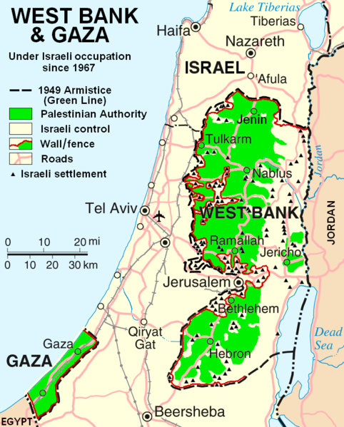
File:West Bank & Gaza Map 2007 (Settlements).png
外觀

預覽大小:482 × 599 像素。 其他解析度:193 × 240 像素 | 386 × 480 像素 | 780 × 970 像素。
原始檔案 (780 × 970 像素,檔案大小:86 KB,MIME 類型:image/png)
檔案歷史
點選日期/時間以檢視該時間的檔案版本。
| 日期/時間 | 縮圖 | 尺寸 | 使用者 | 備註 | |
|---|---|---|---|---|---|
| 目前 | 2013年10月29日 (二) 22:55 |  | 780 × 970(86 KB) | Scott | Correct capitalization in legend. |
| 2013年10月29日 (二) 22:54 |  | 780 × 970(86 KB) | Scott | Correct capitalization in legend. | |
| 2009年1月12日 (一) 06:21 |  | 780 × 970(105 KB) | HowardMorland | Replace .gif file with identical .png file <!--{{ImageUpload|basic}}--> |
檔案用途
沒有使用此檔案的頁面。
全域檔案使用狀況
以下其他 wiki 使用了這個檔案:
- am.wikipedia.org 的使用狀況
- ar.wikipedia.org 的使用狀況
- ast.wikipedia.org 的使用狀況
- azb.wikipedia.org 的使用狀況
- bg.wikipedia.org 的使用狀況
- ca.wikipedia.org 的使用狀況
- ckb.wikipedia.org 的使用狀況
- cs.wikipedia.org 的使用狀況
- cy.wikipedia.org 的使用狀況
- da.wikipedia.org 的使用狀況
- de.wikipedia.org 的使用狀況
- de.wikinews.org 的使用狀況
- de.wikivoyage.org 的使用狀況
- en.wikipedia.org 的使用狀況
- List of cities administered by the Palestinian Authority
- Talk:List of ongoing armed conflicts
- User:Timeshifter/Userboxes
- User:Gimmetrow/test
- User:Gimmetrow/test2
- Talk:Jerusalem/Archive 15
- Talk:Palestinian Authority/Archive 2
- File talk:West Bank & Gaza Map 2007 (Settlements).png
- Wikipedia:Top 25 Report/July 13 to 19, 2014
- Wikipedia:Top 25 Report/July 20 to 26, 2014
- Wikipedia:Top 25 Report/July 27 to August 2, 2014
- Talk:State of Palestine/Archive 12
- User:Timeshifter/Userboxes/Palestine: Peace Not Apartheid. By Jimmy Carter
- User:TheSouthernIrishman
- User:Dare2Leap/info
- User:Timeshifter/Archive 2
- Wikipedia talk:WikiProject Israel Palestine Collaboration/Archive 9
- en.wikinews.org 的使用狀況
- eo.wikipedia.org 的使用狀況
- es.wikipedia.org 的使用狀況
- eu.wikipedia.org 的使用狀況
- fa.wikipedia.org 的使用狀況
- fi.wikipedia.org 的使用狀況
- fo.wikipedia.org 的使用狀況
- fr.wikipedia.org 的使用狀況
檢視此檔案的更多全域使用狀況。

