
File:Transoxiana 8th century.svg

此 SVG 檔案的 PNG 預覽的大小:800 × 388 像素。 其他解析度:320 × 155 像素 | 640 × 310 像素 | 1,024 × 496 像素 | 1,280 × 620 像素 | 2,560 × 1,241 像素 | 1,300 × 630 像素。
原始檔案 (SVG 檔案,表面大小:1,300 × 630 像素,檔案大小:1.86 MB)
摘要
| 描述 |
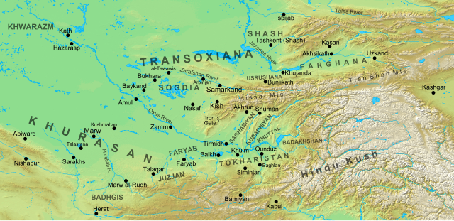
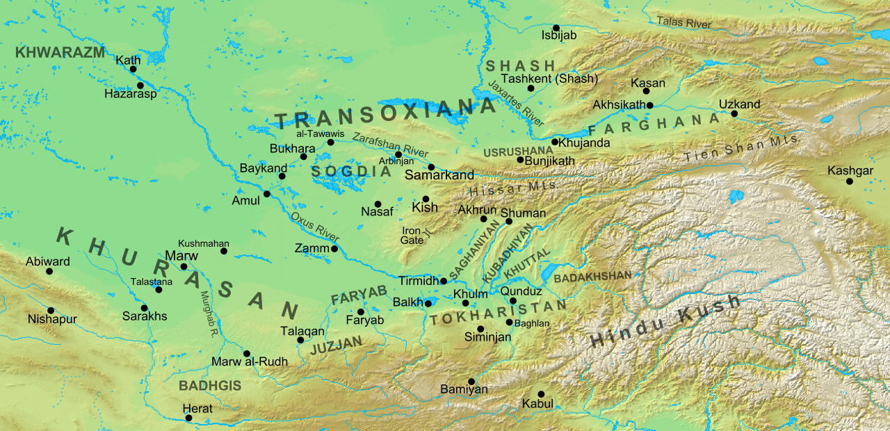
English: Map of the region and principal localities of Transoxiana in the 8th century —.
|
| 日期 | |
| 來源 | 自己的作品 |
| 作者 | Cplakidas |
| 其他版本 |
[]
|


授權條款
我,本作品的著作權持有者,決定用以下授權條款發佈本作品:
此檔案採用創用CC 姓名標示-相同方式分享 3.0 未在地化版本授權條款。
- 您可以自由:
- 分享 – 複製、發佈和傳播本作品
- 重新修改 – 創作演繹作品
- 惟需遵照下列條件:
- 姓名標示 – 您必須指名出正確的製作者,和提供授權條款的連結,以及表示是否有對內容上做出變更。您可以用任何合理的方式來行動,但不得以任何方式表明授權條款是對您許可或是由您所使用。
- 相同方式分享 – 如果您利用本素材進行再混合、轉換或創作,您必須基於如同原先的相同或兼容的條款,來分布您的貢獻成品。
檔案歷史
點選日期/時間以檢視該時間的檔案版本。
| 日期/時間 | 縮圖 | 尺寸 | 使用者 | 備註 | |
|---|---|---|---|---|---|
| 目前 | 2016年10月2日 (日) 15:30 | | 1,300 × 630(1.86 MB) | Cplakidas | added Qunduz |
| 2012年10月15日 (一) 10:32 |  | 1,300 × 630(1.86 MB) | Cplakidas | larger map to include most of Khurasan, additions of cities & provinces | |
| 2012年1月24日 (二) 13:29 |  | 800 × 500(1 MB) | Cplakidas | major revision with more additions & corrections | |
| 2011年12月8日 (四) 17:28 |  | 800 × 500(955 KB) | Cplakidas | added more details, some corrections | |
| 2011年7月25日 (一) 20:34 |  | 800 × 500(895 KB) | Cplakidas |
檔案用途
沒有使用此檔案的頁面。
全域檔案使用狀況
以下其他 wiki 使用了這個檔案:
- ar.wikipedia.org 的使用狀況
- arz.wikipedia.org 的使用狀況
- azb.wikipedia.org 的使用狀況
- az.wikipedia.org 的使用狀況
- Türkdilli dövlətlər
- Usruşana
- Börküyarıq
- Talas döyüşü
- Bahilə qalası uğrunda döyüş
- Susuzluq günü
- Ağsu döyüşü (717)
- Bəykənd döyüşü
- Vikipediya:Həftənin yaxşı məqaləsi/noyabr 2020
- Vikipediya:Həftənin yaxşı məqaləsi/dekabr 2020
- Vikipediya:Həftənin yaxşı məqaləsi/48. Həftə 2020
- Vikipediya:Həftənin yaxşı məqaləsi/49. Həftə 2020
- Böyük Xorasan
- bg.wikipedia.org 的使用狀況
- bn.wikipedia.org 的使用狀況
- bs.wikipedia.org 的使用狀況
- ca.wikipedia.org 的使用狀況
- cs.wikipedia.org 的使用狀況
- de.wikipedia.org 的使用狀況
- de.wikiversity.org 的使用狀況
- el.wikipedia.org 的使用狀況
- en.wikipedia.org 的使用狀況
檢視此檔案的更多全域使用狀況。