
File:Tharsis Tholus block.JPG
此為最大尺寸。
Tharsis_Tholus_block.JPG (284 × 463 像素,檔案大小:16 KB,MIME 類型:image/jpeg)
摘要
| 描述 |
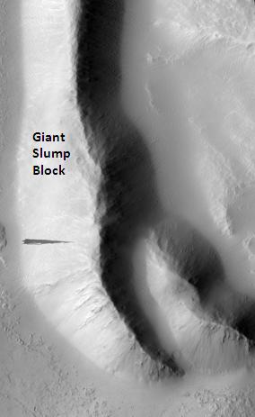
English: Tharsis Tholus block, as seen by hirise. Location is 13.9 degrees north latitude and 267.8 degrees east longitude. Image was taken by the Mars Reconnaissance Orbiter's HiRISE. The HiRISE camera was built by Ball Aerospace and Technology orporation and is operated by the University of Arizona. Image courtesy NASA/JPL/University of Arizona. |
| 日期 | |
| 來源 | http://hirise.lpl.arizona.edu/PSP_007127_1940 |
| 作者 | Jim Secosky modified NASA image. |
授權條款
| 本作品由NASA創作,屬於公有領域。根據NASA的版權政策:“NASA的創作除非另有聲明否則不受版權保護。”(參見:Template:PD-USGov/zh,NASA版權政策或JPL圖像使用政策) | ||
 |
警告:
|
原始上傳日誌
Transferred from en.wikipedia to Commons by FrancescoA.
The original description page was here. All following user names refer to en.wikipedia.
- 2009-03-02 17:58 Jimmarsmars 284×463× (15915 bytes) {{Information |Description=Tharsis Tholus block, as seen by hirise. Location is 13.9 degrees north latitude and 267.8 degrees east longitude. |Source=http://hirise.lpl.arizona.edu/PSP_007127_1940 |Date=March 2, 2009 |Author=Jim Secosky modified NASA imag
檔案歷史
點選日期/時間以檢視該時間的檔案版本。
| 日期/時間 | 縮圖 | 尺寸 | 使用者 | 備註 | |
|---|---|---|---|---|---|
| 目前 | 2009年4月19日 (日) 06:00 | | 284 × 463(16 KB) | FrancescoA | {{Information |Description={{en|Tharsis Tholus block, as seen by hirise. Location is 13.9 degrees north latitude and 267.8 degrees east longitude. Image was taken by the Mars Reconnaissance Orbiter's HiRISE. The HiRISE camera was built by Ball Aerospace |
檔案用途
全域檔案使用狀況
以下其他 wiki 使用了這個檔案:
- bjn.wikipedia.org 的使用狀況
- de.wikipedia.org 的使用狀況
- en.wikipedia.org 的使用狀況
- es.wikipedia.org 的使用狀況
- hi.wikipedia.org 的使用狀況
- id.wikipedia.org 的使用狀況
- jv.wikipedia.org 的使用狀況
- ml.wikipedia.org 的使用狀況
- no.wikipedia.org 的使用狀況
- pl.wikipedia.org 的使用狀況
- pt.wikipedia.org 的使用狀況
- ru.wikipedia.org 的使用狀況
- uk.wikipedia.org 的使用狀況
- vi.wikipedia.org 的使用狀況