
File:Relief Map of Germany, Black Forest.png

預覽大小:506 × 600 像素。 其他解析度:202 × 240 像素 | 405 × 480 像素 | 1,000 × 1,185 像素。
原始檔案 (1,000 × 1,185 像素,檔案大小:1.48 MB,MIME 類型:image/png)
摘要
| 描述 |
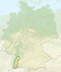
English: Relief map of Germany with outlines of the Black Forest. Equirectangular projection, N/S stretching 150 %. Geographic limits of the map: * N: 55.1° N * S: 47.2° N * W: 5.5° E * E: 15.5° E
Deutsch: Deutschlandkarte mit Umrissen des Schwarzwalds gemäß Naturräumlichen Großregionen Deutschlands nach dem System des Bundesamtes für Naturschutz (BfN). |
| 日期 | (UTC) |
| 來源 |
本檔案衍生自: |
| 作者 |
|


授權條款
此檔案採用創用CC 姓名標示-相同方式分享 3.0 未在地化版本授權條款。
- 您可以自由:
- 分享 – 複製、發佈和傳播本作品
- 重新修改 – 創作演繹作品
- 惟需遵照下列條件:
- 姓名標示 – 您必須指名出正確的製作者,和提供授權條款的連結,以及表示是否有對內容上做出變更。您可以用任何合理的方式來行動,但不得以任何方式表明授權條款是對您許可或是由您所使用。
- 相同方式分享 – 如果您利用本素材進行再混合、轉換或創作,您必須基於如同原先的相同或兼容的條款,來分布您的貢獻成品。
原始上傳日誌
This image is a derivative work of the following images:
- File:Relief_Map_of_Germany.png licensed with Cc-by-sa-3.0
- 2010-08-28T17:48:23Z Виктор В 1000x1185 (1796090 Bytes) Рельеф дна
- 2010-08-28T16:40:16Z Виктор В 1000x1185 (1733013 Bytes) мелкие исправления
- 2010-08-28T12:03:54Z Виктор В 1000x1185 (1766531 Bytes) == {{int:filedesc}} == {{Information |Description={{en|Relief map of [[:en:Germany|Germany]]}} [[:en:Equirectangular projection|Equirectangular projection]], N/S stretching 150 %. Geographic limits of the map: * N: 55.1° N *
- File:Deutschland_Naturraeumliche_Grossregionen.png licensed with Cc-by-sa-3.0, GFDL
- 2011-09-29T17:01:59Z NordNordWest 1826x2318 (5659071 Bytes) upd
- 2011-09-22T18:51:25Z NordNordWest 1826x2318 (5641169 Bytes) ergänzt
- 2011-09-14T18:57:42Z NordNordWest 1826x2318 (5615307 Bytes) update
- 2008-06-12T10:16:41Z NordNordWest 1980x2322 (5911072 Bytes)
- 2008-06-12T09:03:16Z NordNordWest 1979x2322 (5753037 Bytes)
- 2008-06-11T19:04:47Z NordNordWest 1979x2321 (5766960 Bytes) == Beschreibung == {{Information |Description= {{de|Karte der [[:de:Naturräumliche Haupteinheiten Deutschlands|Naturräumlichen Haupteinheiten Deutschlands]] nach dem System des [[:de:Bundesamt für Naturschutz|Bundesamtes f
Uploaded with derivativeFX
檔案歷史
點選日期/時間以檢視該時間的檔案版本。
| 日期/時間 | 縮圖 | 尺寸 | 使用者 | 備註 | |
|---|---|---|---|---|---|
| 目前 | 2013年7月28日 (日) 02:40 | | 1,000 × 1,185(1.48 MB) | Sitacuisses | == {{int:filedesc}} == {{Information |Description={{en|Relief map of Germany with outlines of the Black Forest. Equirectangular projection, N/S stretching 150 %. Geographic limits ... |
檔案用途
下列頁面有用到此檔案:
全域檔案使用狀況
以下其他 wiki 使用了這個檔案:
- af.wikipedia.org 的使用狀況
- arz.wikipedia.org 的使用狀況
- ast.wikipedia.org 的使用狀況
- bh.wikipedia.org 的使用狀況
- bn.wikipedia.org 的使用狀況
- ca.wikipedia.org 的使用狀況
- cs.wikipedia.org 的使用狀況
- da.wikipedia.org 的使用狀況
- de.wikipedia.org 的使用狀況
- en.wikipedia.org 的使用狀況
- en.wikivoyage.org 的使用狀況
- eo.wikipedia.org 的使用狀況
- es.wikipedia.org 的使用狀況
- eu.wikipedia.org 的使用狀況
- fa.wikipedia.org 的使用狀況
- fi.wikipedia.org 的使用狀況
- fr.wikipedia.org 的使用狀況
- ga.wikipedia.org 的使用狀況
- he.wikipedia.org 的使用狀況
- it.wikivoyage.org 的使用狀況
- ja.wikipedia.org 的使用狀況
- ka.wikipedia.org 的使用狀況
- lb.wikipedia.org 的使用狀況
- ml.wikipedia.org 的使用狀況
- pl.wikipedia.org 的使用狀況
- pl.wikivoyage.org 的使用狀況
- ro.wikipedia.org 的使用狀況
- sco.wikipedia.org 的使用狀況
- sk.wikipedia.org 的使用狀況
- sl.wikipedia.org 的使用狀況
- ta.wikipedia.org 的使用狀況
- th.wikipedia.org 的使用狀況
- tr.wikipedia.org 的使用狀況
- ur.wikipedia.org 的使用狀況
- www.wikidata.org 的使用狀況