
File:PIA17595-MarsCuriosityRover-YellowknifeBay-DrillSites-20131224.jpg

原始檔案 (3,525 × 1,380 像素,檔案大小:5.69 MB,MIME 類型:image/jpeg)
摘要
| 描述 |
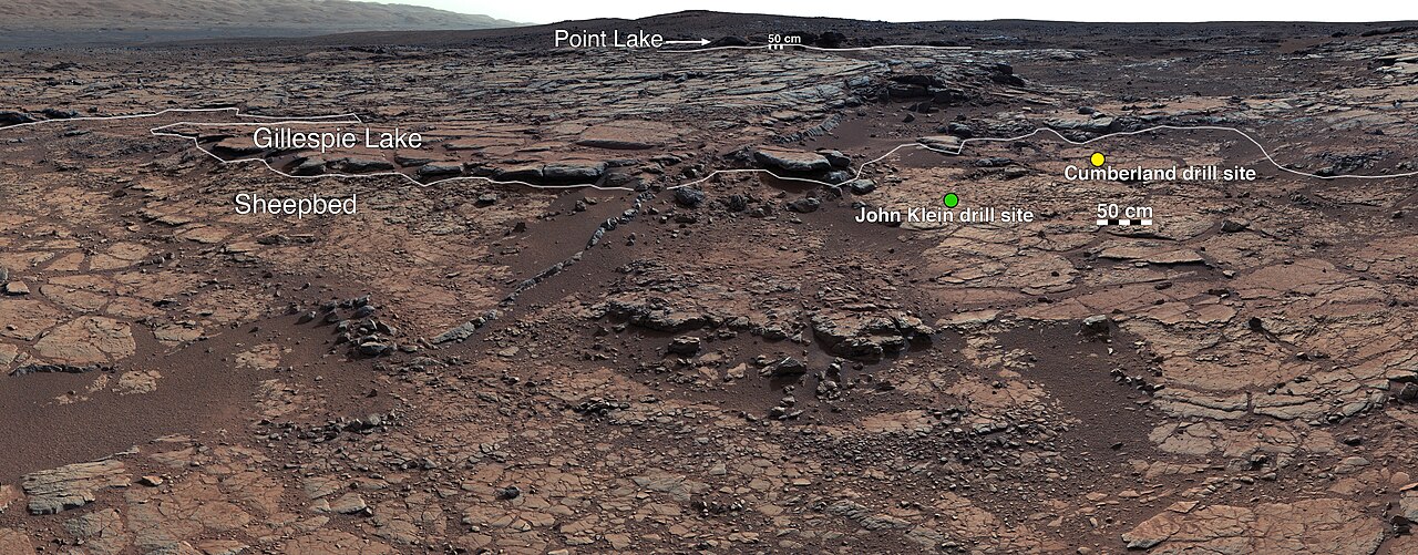
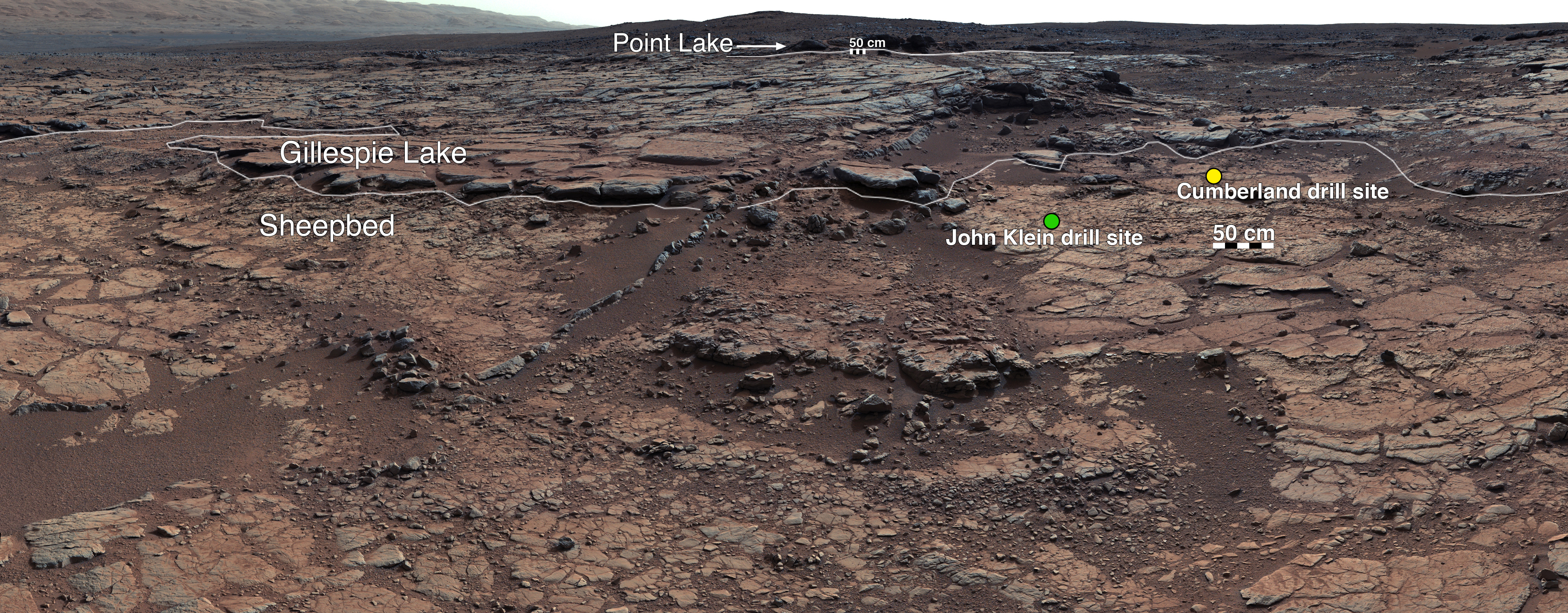
English: PIA17595: View of Yellowknife Bay Formation, with Drilling Sites
http://photojournal.jpl.nasa.gov/catalog/PIA17595 This mosaic of images from Curiosity's Mast Camera (Mastcam) shows geological members of the Yellowknife Bay formation, and the sites where Curiosity drilled into the lowest-lying member, called Sheepbed, at targets "John Klein" and "Cumberland." The scene has the Sheepbed mudstone in the foreground and rises up through Gillespie Lake member to the Point Lake outcrop. These rocks record superimposed ancient lake and stream deposits that offered past environmental conditions favorable for microbial life. Rocks here were exposed about 70 million years ago by removal of overlying layers due to erosion by the wind. The 50-centimeter scale bars at different locations in the image are about 20 inches long. The lower scale bar is about 26 feet (8 meters) away from where Curiosity was positioned when the view was recorded. The upper scale bar is about 98 feet (30 meters) from the rover's location. The scene is a portion of a 111-image mosaic acquired during the 137th Martian day, or sol, of Curiosity's work on Mars (Dec. 24, 2012). The foothills of Mount Sharp are visible in the distance, upper left, southwest of camera position. Malin Space Science Systems, San Diego, built and operates Mastcam. NASA's Jet Propulsion Laboratory manages the Mars Science Laboratory mission and the mission's Curiosity rover for NASA's Science Mission Directorate in Washington. The rover was designed, developed and assembled at JPL, a division of the California Institute of Technology in Pasadena. For more about NASA's Curiosity mission, visit http://www.jpl.nasa.gov/msl, http://www.nasa.gov/mars, and http://marsprogram.jpl.nasa.gov/msl.Polski: PIA17595: Widok obszaru Yellowknife Bay, z zaznaczonymi miejscami użycia wiertarki.
http://photojournal.jpl.nasa.gov/catalog/PIA17595 Zdjęcie ukazuje geologiczne elementy formacji Yellowknife Bay, oraz miejsca gdzie łazik Curiosity realizował wiercenia najniżej położonych skał, nazwanych Sheepbed, "John Klein" i "Cumberland." Na pierwszym planie znajduje się mułowiec Sheepbed i wznosi się przez obszar Gillespie Lake do wychodni Point Lake. Skały tutaj przedstawione zostały odkryte około 70 milionów lat temu poprzez usunięcie warstw wierzchnich energią piasku przesuwanego przez wiatr. Zdjęcie jest całością na którą składa się mozaika zbudowana z 111 zdjęc uzyskanych podczas 137 marsjańskiej doby pracy łazika Curiosity na powierzchni Marsa (24 grudnia 2012). Podnóża góry Sharpa są widoczne w oddali, w górnym lewym rogu, na południowy zachód od pozycji kamery. |
| 日期 | |
| 來源 | http://photojournal.jpl.nasa.gov/figures/PIA17595_fig1.jpg |
| 作者 | NASA/JPL-Caltech/MSSS |
授權條款
| 本作品由NASA創作,屬於公有領域。根據NASA的版權政策:“NASA的創作除非另有聲明否則不受版權保護。”(參見:Template:PD-USGov/zh,NASA版權政策或JPL圖像使用政策) | ||
 |
警告:
|
檔案歷史
點選日期/時間以檢視該時間的檔案版本。
| 日期/時間 | 縮圖 | 尺寸 | 使用者 | 備註 | |
|---|---|---|---|---|---|
| 目前 | 2013年12月20日 (五) 22:22 | 3,525 × 1,380(5.69 MB) | Drbogdan | User created page with UploadWizard |
檔案用途
下列2個頁面有用到此檔案:
全域檔案使用狀況
以下其他 wiki 使用了這個檔案:
- de.wikipedia.org 的使用狀況
- en.wikipedia.org 的使用狀況
- pl.wikipedia.org 的使用狀況