
File:Map of Taungoo Empire (1580).png

預覽大小:508 × 599 像素。 其他解析度:203 × 240 像素 | 407 × 480 像素 | 950 × 1,121 像素。
原始檔案 (950 × 1,121 像素,檔案大小:1.5 MB,MIME 類型:image/png)
.png?uselang=zh-tw)
.png?uselang=zh-tw)
.png?action=history&uselang=zh-tw)
.png)
摘要
| 描述 |
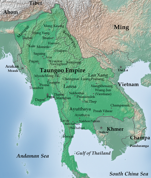
English: Taungoo Empire at its highest extent during the reign of King Bayinnaung (1551-1581) |
| 日期 | |
| 來源 | 自己的作品. Background map is taken from www.naturalearthdata.com (public domain: Terms of Use). |
| 作者 | Soewinhan |
References

Refer to the
- timemap from University of California, Berkeley archive copy at the Wayback Machine for the extent of Ayutthaya, Lang Xang and Lanna before Bayinnaung's conquest.
- Victor B. Lieberman (2003年) 《 Strange parallels: Southeast Asia in global context, c 800-1830, Volume 1》、pp. 152 ISBN: 0521804965. for the extent of Taungoo Empire as of 1580.
- File:Map of Toungoo Kingdom 1572.jpg and File:Map-of-southeast-asia 900 CE.png for geographic names.
- Baker, Chris. Phongpaichit, Pasuk. A History of Ayutthaya: Siam in the Early Modern World.
Notes
- The borders at that times were not demarcated. As stated in Berkeley timemap: The level of details present in some boundaries should not be interpreted as a result of a precise, detailed understanding of the borders of states during this period.
授權條款
我,本作品的著作權持有者,決定用以下授權條款發佈本作品:
此檔案採用創用CC 姓名標示-相同方式分享 3.0 未在地化版本授權條款。
- 您可以自由:
- 分享 – 複製、發佈和傳播本作品
- 重新修改 – 創作演繹作品
- 惟需遵照下列條件:
- 姓名標示 – 您必須指名出正確的製作者,和提供授權條款的連結,以及表示是否有對內容上做出變更。您可以用任何合理的方式來行動,但不得以任何方式表明授權條款是對您許可或是由您所使用。
- 相同方式分享 – 如果您利用本素材進行再混合、轉換或創作,您必須基於如同原先的相同或兼容的條款,來分布您的貢獻成品。
檔案歷史
點選日期/時間以檢視該時間的檔案版本。
| 日期/時間 | 縮圖 | 尺寸 | 使用者 | 備註 | |
|---|---|---|---|---|---|
| 目前 | 2023年7月14日 (五) 02:28 | | 950 × 1,121(1.5 MB) | Yourlocallordandsavior | Reverted to version as of 06:37, 14 February 2023 (UTC) |
| 2023年2月14日 (二) 06:42 |  | 950 × 1,121(1.66 MB) | Yourlocallordandsavior | Reverted to version as of 02:30, 12 February 2023 (UTC) | |
| 2023年2月14日 (二) 06:37 |  | 950 × 1,121(1.5 MB) | Yourlocallordandsavior | Reverted to version as of 07:39, 21 February 2013 (UTC) | |
| 2023年2月12日 (日) 02:30 |  | 950 × 1,121(1.66 MB) | Yourlocallordandsavior | Ayutthaya did not exert its influence down the peninsula in the 16th century. | |
| 2013年2月21日 (四) 07:39 |  | 950 × 1,121(1.5 MB) | Super Rad! | Cropped 1-px transparent border on left and blue border on bottom; reduced image size using PNGOUT | |
| 2011年12月22日 (四) 06:25 |  | 951 × 1,124(2.31 MB) | Soewinhan | ||
| 2011年12月20日 (二) 13:33 |  | 951 × 1,118(2.29 MB) | Soewinhan |
檔案用途
全域檔案使用狀況
以下其他 wiki 使用了這個檔案:
- ar.wikipedia.org 的使用狀況
- azb.wikipedia.org 的使用狀況
- ba.wikipedia.org 的使用狀況
- bn.wikipedia.org 的使用狀況
- ca.wikipedia.org 的使用狀況
- cs.wikipedia.org 的使用狀況
- en.wikipedia.org 的使用狀況
- es.wikipedia.org 的使用狀況
- eu.wikipedia.org 的使用狀況
- id.wikipedia.org 的使用狀況
- it.wikipedia.org 的使用狀況
- ja.wikipedia.org 的使用狀況
- km.wikipedia.org 的使用狀況
- ko.wikipedia.org 的使用狀況
- lt.wikipedia.org 的使用狀況
- mni.wikipedia.org 的使用狀況
- my.wikipedia.org 的使用狀況
- no.wikipedia.org 的使用狀況
- pa.wikipedia.org 的使用狀況
- pl.wikipedia.org 的使用狀況
檢視此檔案的更多全域使用狀況。
.png)
.png)