
File:League of Nations Anachronous Map.PNG
預覽大小:800 × 509 像素。 其他解析度:320 × 204 像素 | 640 × 407 像素 | 1,024 × 651 像素 | 1,357 × 863 像素。
原始檔案 (1,357 × 863 像素,檔案大小:39 KB,MIME 類型:image/png)

|
本圖片是以PNG、GIF或JPEG格式上傳。然而,其中包含的資料或訊息,應該重新建立成可縮放向量圖形(SVG)檔案,以更有效率或更準確的方式儲存。如有可能,請上傳本圖片的SVG格式版本。在上傳之後,請修改維基各姊妹計畫中所有使用舊版圖片的條目(列在圖像連結章節中),替換為新版圖片,並在舊圖片的描述頁中加入{{Vector version available|新圖片名稱.svg}}模板,同時移除本模板。
|

|
本图像(或者本分类中的所有图像)用一个特殊的脚本或语言在内部使用了标签或附属的说明文字,这可以转换为语言中立图表。这样它可以用于所有的维基媒体计划,更重要的是,可以用于所有语言版本的维基媒体计划。
|
摘要
| 描述 |
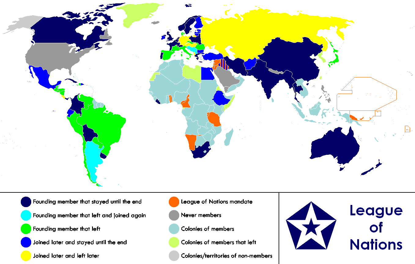
English: Anachronous map of the world between 1920 and 1945 which shows the The League of Nations and the world.
Français : Carte du monde entre 1920 et 1945 montrant la place de la Société des Nations |
| 日期 | |
| 來源 | |
| 作者 | Allard Postman, The Netherlands |
| 其他版本 |
Derivative works of this file: |
授權條款
| 此檔案採用創用CC 姓名標示-相同方式分享 3.0 未在地化版本授權條款。 受免責聲明的約束。 | ||
| ||
| 已新增授權條款標題至此檔案,作為GFDL授權更新的一部份。 |

|
已授權您依據自由軟體基金會發行的無固定段落、封面文字和封底文字GNU自由文件授權條款1.2版或任意後續版本,對本檔進行複製、傳播和/或修改。該協議的副本列在GNU自由文件授權條款中。 受免責聲明的約束。 |
檔案歷史
點選日期/時間以檢視該時間的檔案版本。
| 日期/時間 | 縮圖 | 尺寸 | 使用者 | 備註 | |
|---|---|---|---|---|---|
| 目前 | 2023年2月18日 (六) 23:02 | | 1,357 × 863(39 KB) | RickoTroanman22 | Added vertical striped pattern to Jubaland to indicate that it was transferred to Italy. Removed mostly unrecognized nations (Dervish were not recognized by anyone and Tuva and Mongolia were only recognized by the USSR.) |
| 2021年11月4日 (四) 05:49 |  | 1,357 × 863(59 KB) | Randomastwritter | jubaland | |
| 2019年7月13日 (六) 17:36 |  | 1,357 × 863(50 KB) | Palaeozoic99 | Change Dominion of Newfoundland; colonial status ceased in 1907. Was never a member. | |
| 2011年9月29日 (四) 18:52 |  | 1,357 × 863(47 KB) | DrKay | Restore Mongolia (which was removed based on a map of 1914 but it was independent from 1921) Swap colors of constant members and new members to match the animation gif | |
| 2011年9月28日 (三) 08:01 |  | 1,357 × 863(46 KB) | DrKay | Put non-members in grey (standard color for non-members of an organization) Put original and constant members in same color as the logo of the organization | |
| 2011年1月14日 (五) 09:31 |  | 1,357 × 863(55 KB) | Elmor | minor text corrections | |
| 2011年1月12日 (三) 08:47 |  | 1,357 × 863(55 KB) | Elmor | corrected Japan-Soviet border | |
| 2009年10月9日 (五) 18:43 |  | 1,357 × 863(200 KB) | 23prootie~commonswiki | redo | |
| 2009年10月9日 (五) 18:42 |  | 1,357 × 863(200 KB) | 23prootie~commonswiki | redo | |
| 2009年10月9日 (五) 18:40 |  | 1,357 × 863(184 KB) | 23prootie~commonswiki | Reverted to version as of 16:17, 16 March 2009 |
檔案用途
下列頁面有用到此檔案:
全域檔案使用狀況
以下其他 wiki 使用了這個檔案:
- af.wikipedia.org 的使用狀況
- ast.wikipedia.org 的使用狀況
- as.wikipedia.org 的使用狀況
- be.wikipedia.org 的使用狀況
- bn.wikipedia.org 的使用狀況
- br.wikipedia.org 的使用狀況
- cs.wikipedia.org 的使用狀況
- diq.wikipedia.org 的使用狀況
- en.wikipedia.org 的使用狀況
- es.wikipedia.org 的使用狀況
- eu.wikipedia.org 的使用狀況
- fa.wikipedia.org 的使用狀況
- fi.wikipedia.org 的使用狀況
- fy.wikipedia.org 的使用狀況
- hr.wikipedia.org 的使用狀況
- hy.wikipedia.org 的使用狀況
- io.wikipedia.org 的使用狀況
- is.wikipedia.org 的使用狀況
- ka.wikipedia.org 的使用狀況
- ko.wikipedia.org 的使用狀況
- krc.wikipedia.org 的使用狀況
- lb.wikipedia.org 的使用狀況
- li.wikipedia.org 的使用狀況
- ml.wikipedia.org 的使用狀況
- my.wikipedia.org 的使用狀況
- ne.wikipedia.org 的使用狀況
- nl.wikipedia.org 的使用狀況
- pa.wikipedia.org 的使用狀況
- si.wikipedia.org 的使用狀況
- sk.wikipedia.org 的使用狀況
- sv.wikipedia.org 的使用狀況
- ta.wikipedia.org 的使用狀況
- te.wikipedia.org 的使用狀況
- th.wikipedia.org 的使用狀況