
File:Frankfurt airport hub map v2.png

預覽大小:764 × 600 像素。 其他解析度:306 × 240 像素 | 612 × 480 像素 | 979 × 768 像素 | 1,158 × 909 像素。
原始檔案 (1,158 × 909 像素,檔案大小:1.03 MB,MIME 類型:image/png)
| 描述 |
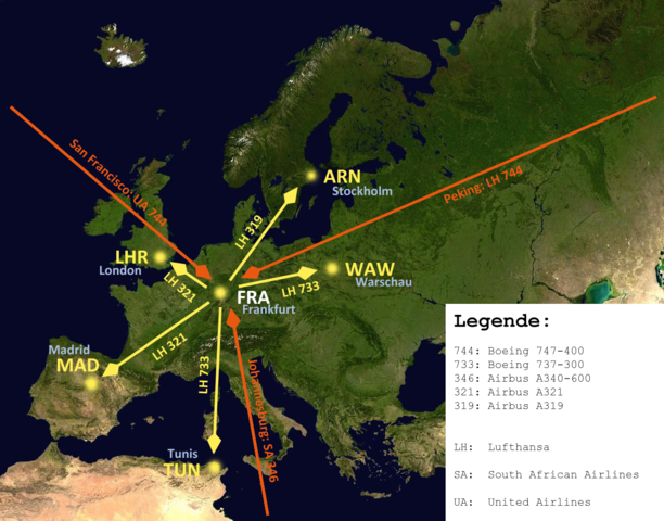
English: A map of Europe to show how an airport-hub is working. Using the example of Lufthansa based in FRA/EDDF. I added some common routes and common aircraft types, flying this route. For better understanding I added a caption. Deutsch: Eine Karte von Europa um das Prinzip eines Luftfahrdrehkreuzes zu verdeutlichen am Beispiel der Lufthansa in FRA/EDDF. Ich habe einige gewöhnliche Routen und die dazu passenden Flugzeugtypen eingetragen und eine Legende hinzugefügt. |
| 日期 | (UTC) |
| 來源 | |
| 作者 |
|
| 這是一張修飾過的圖片,即本圖片是用軟體修改過後的版本,修改的方式或內容有:Fullcity names added。原版圖片來源:Frankfurt airport hub map.png。修改者:Upon a tree。
|
我,本作品的著作權持有者,決定用以下授權條款發佈本作品:
此檔案採用創用CC 姓名標示-相同方式分享 3.0 未在地化版本授權條款。
- 您可以自由:
- 分享 – 複製、發佈和傳播本作品
- 重新修改 – 創作演繹作品
- 惟需遵照下列條件:
- 姓名標示 – 您必須指名出正確的製作者,和提供授權條款的連結,以及表示是否有對內容上做出變更。您可以用任何合理的方式來行動,但不得以任何方式表明授權條款是對您許可或是由您所使用。
- 相同方式分享 – 如果您利用本素材進行再混合、轉換或創作,您必須基於如同原先的相同或兼容的條款,來分布您的貢獻成品。
此檔案採用創用CC 姓名標示-相同方式分享 3.0 未在地化版本授權條款。
- 您可以自由:
- 分享 – 複製、發佈和傳播本作品
- 重新修改 – 創作演繹作品
- 惟需遵照下列條件:
- 姓名標示 – 您必須指名出正確的製作者,和提供授權條款的連結,以及表示是否有對內容上做出變更。您可以用任何合理的方式來行動,但不得以任何方式表明授權條款是對您許可或是由您所使用。
- 相同方式分享 – 如果您利用本素材進行再混合、轉換或創作,您必須基於如同原先的相同或兼容的條款,來分布您的貢獻成品。
您可以選擇您需要的授權條款。
原始上傳日誌
This image is a derivative work of the following images:
- Image:Frankfurt_airport_hub_map.png licensed with Cc-by-sa-3.0, Cc-by-sa-3.0
- 2008-12-10T17:12:37Z Upon a tree 1158x909 (1028574 Bytes) {{Information |Description={{en|1=A map of Europe to show how a airport-hub is working. Using the example of Lufthansa based in FRA/EDDF. I added some common routes and common aircraft types, flying this route. For bether und
Uploaded with derivativeFX
檔案歷史
點選日期/時間以檢視該時間的檔案版本。
| 日期/時間 | 縮圖 | 尺寸 | 使用者 | 備註 | |
|---|---|---|---|---|---|
| 目前 | 2008年12月11日 (四) 11:03 | | 1,158 × 909(1.03 MB) | Upon a tree | {{Information |Description={{en|1=A map of Europe to show how an airport-hub is working. Using the example of Lufthansa based in FRA/EDDF. I added some common routes and common aircraft types, flying this route. For bether understanding I added a caption. |
檔案用途
下列頁面有用到此檔案:
全域檔案使用狀況
以下其他 wiki 使用了這個檔案:
- af.wikipedia.org 的使用狀況
- ar.wikipedia.org 的使用狀況
- ast.wikipedia.org 的使用狀況
- az.wikipedia.org 的使用狀況
- bn.wikipedia.org 的使用狀況
- ca.wikipedia.org 的使用狀況
- cs.wikipedia.org 的使用狀況
- da.wikipedia.org 的使用狀況
- de.wikipedia.org 的使用狀況
- en.wikipedia.org 的使用狀況
- eo.wikipedia.org 的使用狀況
- es.wikipedia.org 的使用狀況
- et.wikipedia.org 的使用狀況
- fa.wikipedia.org 的使用狀況
- fr.wikipedia.org 的使用狀況
- hak.wikipedia.org 的使用狀況
- hi.wikipedia.org 的使用狀況
- id.wikipedia.org 的使用狀況
- it.wikipedia.org 的使用狀況
- ja.wikipedia.org 的使用狀況
- kk.wikipedia.org 的使用狀況
- ko.wikipedia.org 的使用狀況
- nl.wikipedia.org 的使用狀況
- pl.wikipedia.org 的使用狀況
- simple.wikipedia.org 的使用狀況
- sv.wikipedia.org 的使用狀況
- tr.wikipedia.org 的使用狀況