
File:Egypt Sudan claims.svg

此 SVG 檔案的 PNG 預覽的大小:400 × 600 像素。 其他解析度:160 × 240 像素 | 320 × 480 像素 | 512 × 768 像素 | 682 × 1,024 像素 | 1,365 × 2,048 像素。
原始檔案 (SVG 檔案,表面大小:512 × 768 像素,檔案大小:461 KB)
摘要
| 描述 |
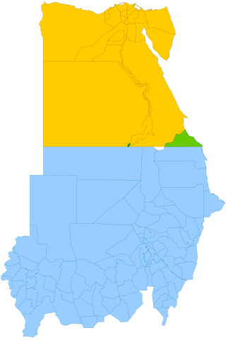
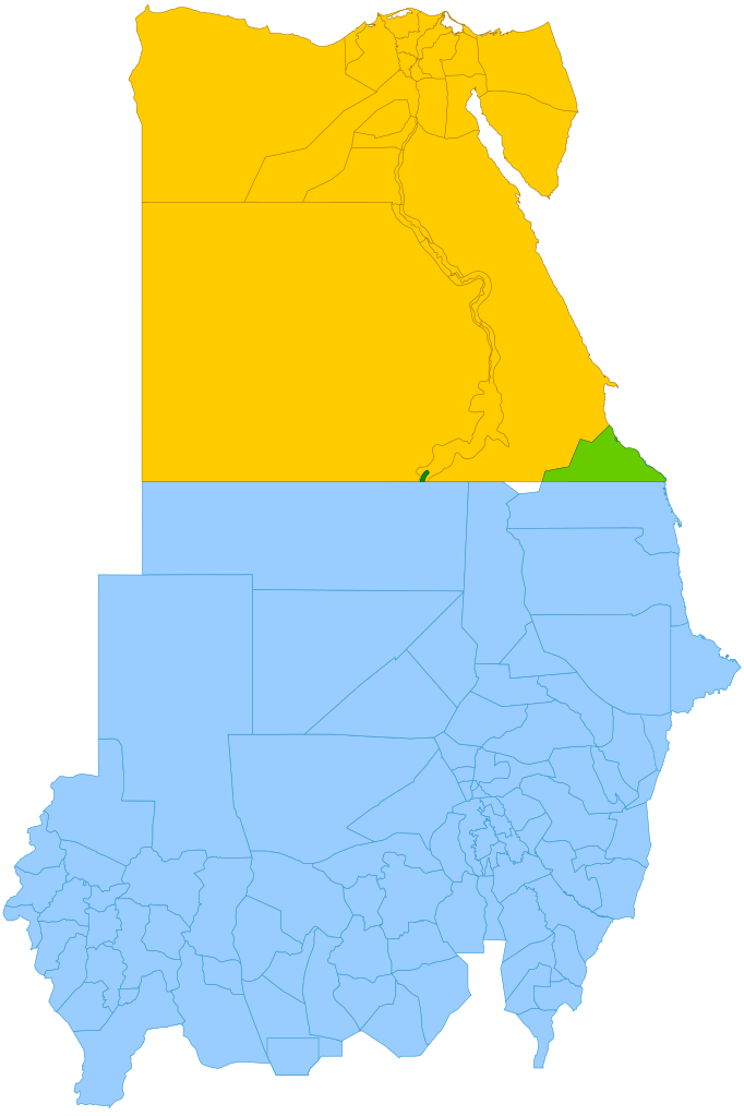
English: Simplified map showing Egypt's claim (yellow and green), Sudan's claim (blue and green), the Hala'ib Triangle (light green), Wadi Halfa Salient (dark green) and Bir Tawil (white). |
| 日期 | (UTC) |
| 來源 |
本檔案衍生自: |
| 作者 | |
| SVG開發 |

授權條款
此檔案採用創用CC 姓名標示-相同方式分享 3.0 未在地化版本授權條款。
- 您可以自由:
- 分享 – 複製、發佈和傳播本作品
- 重新修改 – 創作演繹作品
- 惟需遵照下列條件:
- 姓名標示 – 您必須指名出正確的製作者,和提供授權條款的連結,以及表示是否有對內容上做出變更。您可以用任何合理的方式來行動,但不得以任何方式表明授權條款是對您許可或是由您所使用。
- 相同方式分享 – 如果您利用本素材進行再混合、轉換或創作,您必須基於如同原先的相同或兼容的條款,來分布您的貢獻成品。
原始上傳日誌
This image is a derivative work of the following images:
- File:Political_Regions_of_Sudan,_July_2010.svg licensed with Cc-zero
- File:Egypt_location_map.svg licensed with Cc-by-sa-3.0, GFDL
- 2011-04-17T16:03:10Z NordNordWest 1055x973 (359140 Bytes) upd
- 2010-03-07T17:03:18Z NordNordWest 1055x973 (566369 Bytes) resize
- 2009-09-03T10:48:31Z NordNordWest 1055x956 (565065 Bytes)
- 2009-05-23T19:10:12Z NordNordWest 1056x959 (570357 Bytes) corr
- 2008-08-10T11:12:09Z NordNordWest 1056x957 (503154 Bytes) {{Information |Description= {{de|Positionskarte von [[:de:Ägypten|Ägypten]]}} Quadratische Plattkarte, N-S-Streckung 110 %. Geographische Begrenzung der Karte: * N: 32.1° N * S: 21.3° N * W: 24.2° O * O: 37.3° O {{en|Lo
Uploaded with derivativeFX
檔案歷史
點選日期/時間以檢視該時間的檔案版本。
| 日期/時間 | 縮圖 | 尺寸 | 使用者 | 備註 | |
|---|---|---|---|---|---|
| 目前 | 2021年10月13日 (三) 11:15 | | 512 × 768(461 KB) | Cmglee | Shade Wadi Halfa Salient as per http://commons.wikimedia.org/wiki/File_talk:Egypt_Sudan_claims.svg#Wadi_Halfa_Salient |
| 2019年2月16日 (六) 12:58 |  | 512 × 768(461 KB) | AntiCompositeNumber | Avoid messing with file structure so much when <!-- --> will work | |
| 2019年2月16日 (六) 12:51 |  | 512 × 768(465 KB) | AntiCompositeNumber | Remove striping that makes image harder to see per request at e n:Wikipedia:Graphics_Lab/Map_workshop | |
| 2018年6月21日 (四) 17:47 |  | 512 × 768(461 KB) | Cmglee | Add white background as per File_talk:Egypt_Sudan_claims.svg#Bir_Tawil_area | |
| 2015年11月8日 (日) 17:44 |  | 512 × 768(460 KB) | McGeddon | Remove unnecessary captions, image is colour-coded. | |
| 2013年1月11日 (五) 21:28 |  | 512 × 768(461 KB) | Cmglee | Update colours and label alignment. | |
| 2013年1月11日 (五) 21:19 |  | 512 × 768(461 KB) | Cmglee | == {{int:filedesc}} == {{Information |Description={{en|Map showing political regions of Sudan as of July 2006.}} {{legend|#8cc63f|Darfur}} {{legend|#fb6282|Nuba Mountains and Blue Nile}} {{legend|#f7931d|North Sudan}} {{legend|#800080|Eastern Front, ar... |
檔案用途
下列4個頁面有用到此檔案:
全域檔案使用狀況
以下其他 wiki 使用了這個檔案:
- ar.wikipedia.org 的使用狀況
- arz.wikipedia.org 的使用狀況
- az.wikipedia.org 的使用狀況
- be.wikipedia.org 的使用狀況
- da.wikipedia.org 的使用狀況
- de.wikipedia.org 的使用狀況
- de.wikivoyage.org 的使用狀況
- el.wikipedia.org 的使用狀況
- en.wikipedia.org 的使用狀況
- en.wikivoyage.org 的使用狀況
- eo.wikipedia.org 的使用狀況
- es.wikipedia.org 的使用狀況
- fi.wikipedia.org 的使用狀況
- fr.wikipedia.org 的使用狀況
- gl.wikipedia.org 的使用狀況
- id.wikipedia.org 的使用狀況
- it.wikipedia.org 的使用狀況
- ja.wikipedia.org 的使用狀況
- ja.wikivoyage.org 的使用狀況
- ko.wikipedia.org 的使用狀況
- ms.wikipedia.org 的使用狀況
- nl.wikipedia.org 的使用狀況
- no.wikipedia.org 的使用狀況
- pt.wikipedia.org 的使用狀況
- ro.wikipedia.org 的使用狀況
- so.wikipedia.org 的使用狀況
- sr.wikipedia.org 的使用狀況
- uk.wikipedia.org 的使用狀況
- vi.wikipedia.org 的使用狀況
- www.wikidata.org 的使用狀況