
File:2018 OCHA OpT map East Jerusalem.jpg
原始檔案 (1,768 × 2,500 像素,檔案大小:920 KB,MIME 類型:image/jpeg)
摘要
| 描述 |
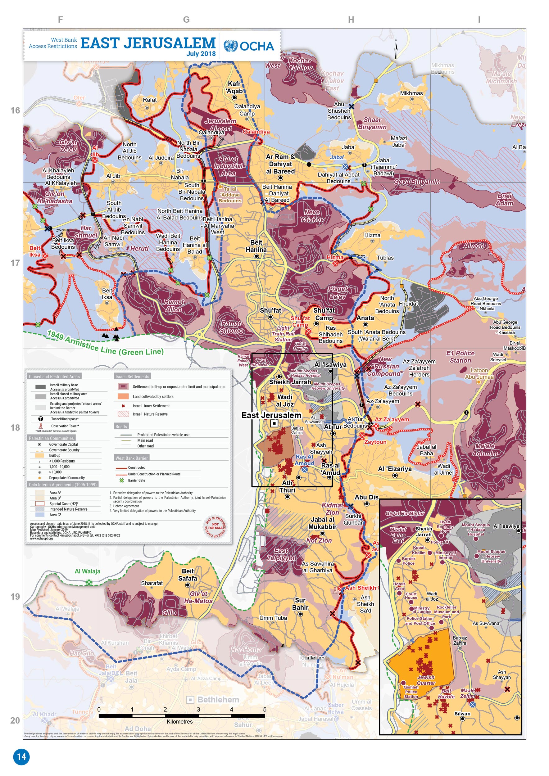
English: 2018 OCHA OpT map |
| 日期 | |
| 來源 | https://www.ochaopt.org/atlas2019/wbclosure.html |
| 作者 | OCHA OpT |
| 其他版本 |
.jpg)
.jpg)
_in_the_2018_OCHA_OpT_map_East_Jerusalem_(cropped).jpg)
授權條款
| This image is a map derived from a United Nations map.
Unless stated otherwise, UN maps are to be considered in the public domain. This applies worldwide. UN maps are, in principle, open source material and you can use them in your work or for making your own map. UN requests however that you delete the UN name, logo and reference number upon any modification to the map. Content of your map will be your responsibility. You can state in your publication, if you wish, something like: based on UN map … (map name, map number, revision number and date). See: Geospatial Information Section. And: Geospatial, location data for a better world. |
 |
檔案歷史
點選日期/時間以檢視該時間的檔案版本。
| 日期/時間 | 縮圖 | 尺寸 | 使用者 | 備註 | |
|---|---|---|---|---|---|
| 目前 | 2021年2月8日 (一) 23:00 | | 1,768 × 2,500(920 KB) | Altanner1991 | Reverted to version as of 19:25, 30 December 2020 (UTC) Note: In the future it would be helpful if "Old City" was written somewhere on the map. |
| 2021年1月9日 (六) 03:33 |  | 1,768 × 2,500(1.37 MB) | Altanner1991 | Could you explain what part is "original research"? | |
| 2020年12月30日 (三) 19:25 |  | 1,768 × 2,500(920 KB) | Onceinawhile | Reverted to UN map without "original research" | |
| 2020年10月31日 (六) 11:12 |  | 1,768 × 2,500(1.37 MB) | Altanner1991 | removing Old Jerusalem as Jewish and writing "Old City" | |
| 2020年7月3日 (五) 11:44 |  | 1,768 × 2,500(920 KB) | Onceinawhile | Uploaded a work by OCHA OpT from https://www.ochaopt.org/atlas2019/wbclosure.html with UploadWizard |
檔案用途
下列頁面有用到此檔案:
全域檔案使用狀況
以下其他 wiki 使用了這個檔案:
- az.wikipedia.org 的使用狀況
- el.wikipedia.org 的使用狀況
- en.wikipedia.org 的使用狀況
- es.wikipedia.org 的使用狀況
- ko.wikipedia.org 的使用狀況
- no.wikipedia.org 的使用狀況
- uz.wikipedia.org 的使用狀況