
File:2011 Census Scheduled Caste caste distribution map India by state and union territory.svg

此 SVG 檔案的 PNG 預覽的大小:531 × 599 像素。 其他解析度:213 × 240 像素 | 425 × 480 像素 | 681 × 768 像素 | 907 × 1,024 像素 | 1,815 × 2,048 像素 | 1,650 × 1,862 像素。
原始檔案 (SVG 檔案,表面大小:1,650 × 1,862 像素,檔案大小:1.44 MB)
摘要
| 描述 |
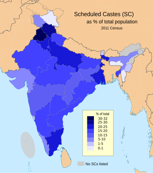
English: This demographic map shows Scheduled Castes (SC, Dalit) as a percent of each state and union territory's population per 2011 Census of India. Punjab had the highest percentage Dalit population in 2011 among all Indian states (31.9%), while Nagaland, Arunachal Pradesh, Andaman & Nicobar Islands and Lakshadweep had 0%.
Source: Census of India 2011, Primary Census Abstract - Scheduled castes and scheduled tribes, Office of the Registrar General & Census Commissioner, India (October 28 2013). The data can be viewed in a Powerpoint presentation on a Government of India Census website here. The disputed national borders SVG code in this map is a derivative work of File:India literacy rate map en.svg available on wikimedia commons. |
| 日期 | |
| 來源 | 自己的作品 |
| 作者 | M Tracy Hunter |
授權條款
我,本作品的著作權持有者,決定用以下授權條款發佈本作品:
此檔案採用創用CC 姓名標示-相同方式分享 3.0 未在地化版本授權條款。
- 您可以自由:
- 分享 – 複製、發佈和傳播本作品
- 重新修改 – 創作演繹作品
- 惟需遵照下列條件:
- 姓名標示 – 您必須指名出正確的製作者,和提供授權條款的連結,以及表示是否有對內容上做出變更。您可以用任何合理的方式來行動,但不得以任何方式表明授權條款是對您許可或是由您所使用。
- 相同方式分享 – 如果您利用本素材進行再混合、轉換或創作,您必須基於如同原先的相同或兼容的條款,來分布您的貢獻成品。
檔案歷史
點選日期/時間以檢視該時間的檔案版本。
| 日期/時間 | 縮圖 | 尺寸 | 使用者 | 備註 | |
|---|---|---|---|---|---|
| 目前 | 2023年3月8日 (三) 19:21 | | 1,650 × 1,862(1.44 MB) | Aishik Rehman | File uploaded using svgtranslate tool (https://svgtranslate.toolforge.org/). Added translation for bn. |
| 2020年6月1日 (一) 19:19 |  | 1,650 × 1,862(1.48 MB) | C1MM | Coloured island | |
| 2020年6月1日 (一) 19:16 |  | 1,650 × 1,862(1.48 MB) | C1MM | Removed fills | |
| 2020年3月22日 (日) 00:03 |  | 1,650 × 1,859(1.91 MB) | C1MM | Wording | |
| 2020年3月22日 (日) 00:02 |  | 1,650 × 1,859(1.91 MB) | C1MM | Added no SC locations | |
| 2020年3月21日 (六) 22:17 |  | 1,650 × 1,859(1.91 MB) | C1MM | Larger version of before file | |
| 2020年3月21日 (六) 22:14 |  | 1,650 × 1,859(1.9 MB) | C1MM | Removed unnecessary names of states and capitals, used different map for the states and added Ladakh and J&K as separate UTs | |
| 2015年8月23日 (日) 23:11 |  | 1,650 × 1,859(934 KB) | Utcursch | fix text flowing out of the image | |
| 2015年8月23日 (日) 22:54 |  | 1,578 × 1,738(862 KB) | Utcursch | use the term used in the source; see en:Talk:Dalit#Image_Remove | |
| 2014年7月16日 (三) 11:49 |  | 1,578 × 1,738(863 KB) | M Tracy Hunter | Caption |
檔案用途
下列頁面有用到此檔案:
全域檔案使用狀況
以下其他 wiki 使用了這個檔案:
- as.wikipedia.org 的使用狀況
- bh.wikipedia.org 的使用狀況
- bn.wikipedia.org 的使用狀況
- en.wikipedia.org 的使用狀況
- eo.wikipedia.org 的使用狀況
- es.wikipedia.org 的使用狀況
- et.wikipedia.org 的使用狀況
- he.wikipedia.org 的使用狀況
- hi.wikipedia.org 的使用狀況
- it.wikipedia.org 的使用狀況
- lv.wikipedia.org 的使用狀況
- ml.wikipedia.org 的使用狀況
- mr.wikipedia.org 的使用狀況
- ne.wikipedia.org 的使用狀況
- nn.wikipedia.org 的使用狀況
- pi.wikipedia.org 的使用狀況
- ru.wikipedia.org 的使用狀況
- sq.wikipedia.org 的使用狀況
- ta.wikipedia.org 的使用狀況
- th.wikipedia.org 的使用狀況
- uk.wikipedia.org 的使用狀況
- www.wikidata.org 的使用狀況