
File:Zealandia, topographic map.jpg

預覽大小:529 × 600 像素。 其他解析度:212 × 240 像素 | 423 × 480 像素 | 678 × 768 像素 | 903 × 1,024 像素 | 1,500 × 1,700 像素。
原始檔案 (1,500 × 1,700 像素,檔案大小:4.57 MB,MIME 類型:image/jpeg)
摘要
| 描述 |
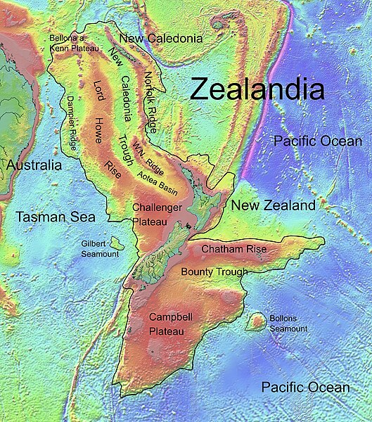
Deutsch: Die topografische Karte von Zealandia basiert auf den Bathymetrie-Daten des Scripps Institution of Oceanography, University of California, San Diego.
Die Umrandung zw. Grenzziehung basiert auf Informationen des Buches: Nick Mortimer; Hamish Campbell (2014年) 《 Zealandia - Our Continent Revealed》、倫敦: Penguin Books、第54頁 ISBN: 978-0-143-57156-8. English: Topographic map of Zealandia, based on bathymetry data from Scripps Institution of Oceanography, University of California, San Diego.
Boundary is based on information which was given in: Nick Mortimer; Hamish Campbell (2014年) 《 Zealandia - Our Continent Revealed》、倫敦: Penguin Books、第54頁 ISBN: 978-0-143-57156-8. Français : Carte topographique du continent de Zealandia, basée sur des données bathymétriques du Scripps Institution of Oceanography, Université de Californie, San Diego, États-Unis. La limite du continent est tirée d'informations venant de : « Nick Mortimer; Hamish Campbell (2014年) 《 Zealandia - Our Continent Revealed》、Londres: Penguin Books、第54頁 ISBN: 978-0-143-57156-8. ». |
| 日期 | |
| 來源 | http://topex.ucsd.edu/WWW_html/mar_topo.html; http://topex.ucsd.edu/marine_topo/jpg_images/topo10.jpg; http://topex.ucsd.edu/marine_topo/jpg_images/topo11.jpg; http://topex.ucsd.edu/marine_topo/jpg_images/topo14.jpg; http://topex.ucsd.edu/marine_topo/jpg_images/topo15.jpg |
| 作者 | Ulrich Lange, Bochum, Germany |
| 其他版本 |
 |
There is no copyright on published bathmetry data, (free use)
授權條款
我,本作品的著作權持有者,決定用以下授權條款發佈本作品:
| 此檔案在創用CC CC0 1.0 通用公有領域貢獻宣告之下分發。 | |
| 在此宣告之下分發本作品者,已依據各國著作權法,在全世界放棄其對本作品所擁有的著作權及所有相關相似的法律權利,從而將本作品貢獻至公有領域。您可以複製、修改、分發和演示該作品,用於任何商業用途,所有這些都不需要請求授權。
|
檔案歷史
點選日期/時間以檢視該時間的檔案版本。
| 日期/時間 | 縮圖 | 尺寸 | 用戶 | 備註 | |
|---|---|---|---|---|---|
| 目前 | 2019年2月9日 (六) 16:55 | | 1,500 × 1,700(4.57 MB) | Ulanwp | spelling of Bollons Seamount corrected |
| 2017年3月21日 (二) 20:43 |  | 1,500 × 1,700(4.57 MB) | Ulanwp | Geographical Names inserted | |
| 2017年3月20日 (一) 19:59 |  | 1,500 × 1,700(4.44 MB) | Ulanwp | {{Information |Description ={{en|1=Topographic map of Zealandia, based on bathmetry data from Scripps Institution of Oceanography, University of California, San Diego}} |Source =http://topex.ucsd.edu/WWW_html/mar_topo.html |Author =U... |
檔案用途
下列頁面有用到此檔案:
全域檔案使用狀況
以下其他 wiki 使用了這個檔案:
- ar.wikipedia.org 的使用狀況
- ast.wikipedia.org 的使用狀況
- bg.wikipedia.org 的使用狀況
- ca.wikipedia.org 的使用狀況
- ceb.wikipedia.org 的使用狀況
- de.wikipedia.org 的使用狀況
- Lord Howe Rise
- Zealandia
- Gisborne-Erdbeben von 2007
- Geologie Neuseelands
- Geographie Neuseelands
- Chatham Rise
- Campbell Plateau
- Bounty Trough
- Norfolk Ridge
- New Caledonia Trough
- Challenger Plateau
- Geologie der Antarktischen Halbinsel
- Geologie Ostantarktikas
- Vulkanische Provinzen der Antarktischen Halbinsel
- en.wikipedia.org 的使用狀況
- Chatham Rise
- Lord Howe Rise
- South Tasman Rise
- Campbell Plateau
- Meiolania
- Challenger Plateau
- Norfolk Ridge
- Lord Howe Seamount Chain
- Continent
- Submerged continent
- East Tasman Plateau
- Bollons Seamount
- Bounty Trough
- Tasmantid Seamount Chain
- Tasmantid hotspot
- Joseph Gilbert Seamount
- Gascoyne Seamount
- Geology of New Caledonia
- Taupo Bank
- Derwent Hunter Guyot
- Britannia Guyots
- Queensland Guyot
- Geology of Zealandia
- Three Kings Ridge
- es.wikipedia.org 的使用狀況
- eu.wikipedia.org 的使用狀況
- fr.wikipedia.org 的使用狀況
檢視此檔案的更多全域使用狀況。