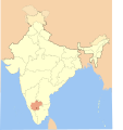
File:Western-ganga-empire-map.svg
外觀

此 SVG 檔案的 PNG 預覽的大小:565 × 600 像素。 其他解析度:226 × 240 像素 | 452 × 480 像素 | 723 × 768 像素 | 964 × 1,024 像素 | 1,929 × 2,048 像素 | 1,651 × 1,753 像素。
原始檔案 (SVG 檔案,表面大小:1,651 × 1,753 像素,檔案大小:430 KB)
檔案歷史
點選日期/時間以檢視該時間的檔案版本。
| 日期/時間 | 縮圖 | 尺寸 | 用戶 | 備註 | |
|---|---|---|---|---|---|
| 目前 | 2007年5月28日 (一) 00:40 |  | 1,651 × 1,753(430 KB) | Mlpkr | I used Image:India-locator-map-blank.svg as base and edited myself using inkspace and created it by looking at the following sources. * Malini Adiga (2006), The Making of Southern Karnataka: Society, Polity and Culture in the early medieval period, |
| 2007年5月28日 (一) 00:16 |  | 1,651 × 1,753(431 KB) | Mlpkr | I used Image:India-locator-map-blank.svg as base and edited myself using inkspace and created it by looking at the following sources. * Malini Adiga (2006), The Making of Southern Karnataka: Society, Polity and Culture in the early medieval period, |
檔案用途
下列頁面有用到此檔案:
全域檔案使用狀況
以下其他 wiki 使用了這個檔案:
- ar.wikipedia.org 的使用狀況
- azb.wikipedia.org 的使用狀況
- bn.wikipedia.org 的使用狀況
- ca.wikipedia.org 的使用狀況
- en.wikipedia.org 的使用狀況
- es.wikipedia.org 的使用狀況
- fa.wikipedia.org 的使用狀況
- fr.wikipedia.org 的使用狀況
- hi.wikipedia.org 的使用狀況
- hu.wikipedia.org 的使用狀況
- id.wikipedia.org 的使用狀況
- it.wikipedia.org 的使用狀況
- ka.wikipedia.org 的使用狀況
- kn.wikipedia.org 的使用狀況
- ko.wikipedia.org 的使用狀況
- lt.wikipedia.org 的使用狀況
- ml.wikipedia.org 的使用狀況
- ne.wikipedia.org 的使用狀況
- pnb.wikipedia.org 的使用狀況
- pt.wikipedia.org 的使用狀況
- ru.wikipedia.org 的使用狀況
- sh.wikipedia.org 的使用狀況
- ta.wikipedia.org 的使用狀況
- tr.wikipedia.org 的使用狀況
- uk.wikipedia.org 的使用狀況
- ur.wikipedia.org 的使用狀況
- www.wikidata.org 的使用狀況
