
File:PIA23514-Mars-WaterIce-LikeliestAreas-20191210.jpg

預覽大小:800 × 357 像素。 其他解析度:320 × 143 像素 | 640 × 286 像素 | 1,614 × 720 像素。
原始檔案 (1,614 × 720 像素,檔案大小:304 KB,MIME 類型:image/jpeg)
摘要
| 描述 |
English: A Water Ice Map for Mars
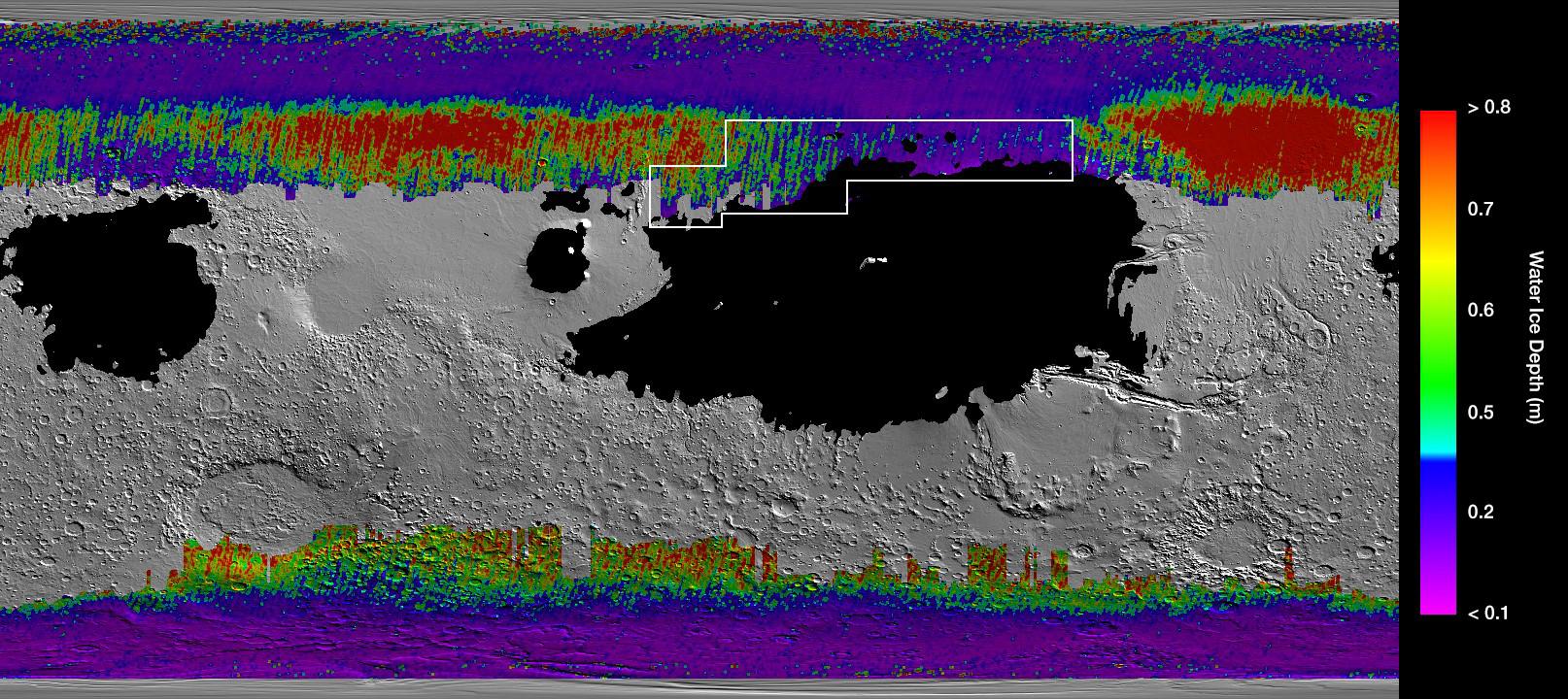
https://www.jpl.nasa.gov/spaceimages/details.php?id=PIA23514 This rainbow-colored map shows underground water ice on Mars. This rainbow-colored map shows underground water ice on Mars. Cool colors represent less than one foot (30 centimeters) below the surface; warm colors are over two feet (60 centimeters) deep. Sprawling black zones on the map represent areas where a landing spacecraft would sink into fine dust. The outlined box represents the ideal region to send astronauts for them to be able to dig up water ice. The map was created by combining data from multiple NASA orbiters, including the Mars Reconnaissance Orbiter and its Mars Climate Sounder instrument; Mars Odyssey and its Thermal Emission Imaging System; and the Mars Global Surveyor. |
| 日期 | |
| 來源 | https://photojournal.jpl.nasa.gov/jpeg/PIA23514.jpg |
| 作者 | NASA/JPL-Caltech/ASU |
授權條款
| 本作品由NASA創作,屬於公有領域。根據NASA的版權政策:“NASA的創作除非另有聲明否則不受版權保護。”(參見:Template:PD-USGov/zh,NASA版權政策或JPL圖像使用政策) | ||
 |
警告:
|
檔案歷史
點選日期/時間以檢視該時間的檔案版本。
| 日期/時間 | 縮圖 | 尺寸 | 用戶 | 備註 | |
|---|---|---|---|---|---|
| 目前 | 2019年12月11日 (三) 00:53 | | 1,614 × 720(304 KB) | Drbogdan | User created page with UploadWizard |
檔案用途
下列頁面有用到此檔案:
全域檔案使用狀況
以下其他 wiki 使用了這個檔案:
- bn.wikipedia.org 的使用狀況
- de.wikipedia.org 的使用狀況
- en.wikipedia.org 的使用狀況
- ro.wikipedia.org 的使用狀況