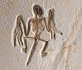
English: Fossil Butte National Monument
Fossil Butte National Monument is a United States National Monument managed by the National Park Service, located 15 miles (24 km) west of Kemmerer, Wyoming, United States. It centers on an extraordinary assemblage of Eocene Epoch (56 to 34 million years ago) animal and plant fossils associated with Fossil Lake—the smallest lake of the three great lakes which were then present in what are now Wyoming, Utah, and Colorado. The other two lakes were Lake Gosiute and Lake Uinta. Fossil Butte National Monument was established as a national monument on October 23, 1972.
Fossil Butte National Monument preserves the best paleontological record of Cenozoic aquatic communities in North America and possibly the world, within the 50-million-year-old Green River Formation — the ancient lake bed. Fossils preserved — including fish, alligators, bats, turtles, dog-sized horses, insects, and many other species of plants and animals — suggest that the region was a low, subtropical, freshwater basin when the sediments accumulated, over about a 2 million-year period.
During the Eocene this portion of Wyoming was a sub-tropical lake ecosystem. The Green River Lake System contained three ancient lakes, Fossil Lake, Lake Gosiute, and Lake Uinta. These lakes covered parts of southwest Wyoming, northeast Utah and northwestern Colorado. Fossil Butte is a remnant of the deposits from Fossil Lake. Fossil Lake was 40 to 50 miles (64 to 80 km) long from north to south and 20 miles (32 km) wide. Over the two million years that it existed, the lake varied in length and width.
Fossil Buttes National Monument contains only 13 square miles (8,198 acres (33,180,000 m2)) of the 900-square-mile (595,200 acres (2.409×10⁹ m2)) ancient lake. The ancient lake sediments that form the primary fossil digs is referred to as the Green River Formation. In addition to this fossil-bearing strata, a large portion of the Wasatch Formation, river and stream sediments, is within the national monument. The Wasatch Formation represents the shoreline ecosystem around the lake and contains fossil teeth and bone fragments of Eocene mammals. Among these are early primates and horses.


