
File:Lena River Delta - Landsat 2000.jpg

預覽大小:600 × 600 像素。 其他解析度:240 × 240 像素 | 480 × 480 像素 | 768 × 768 像素 | 1,024 × 1,024 像素 | 2,048 × 2,048 像素 | 3,100 × 3,100 像素。
原始檔案 (3,100 × 3,100 像素,檔案大小:4.18 MB,MIME 類型:image/jpeg)
摘要
| 描述 |
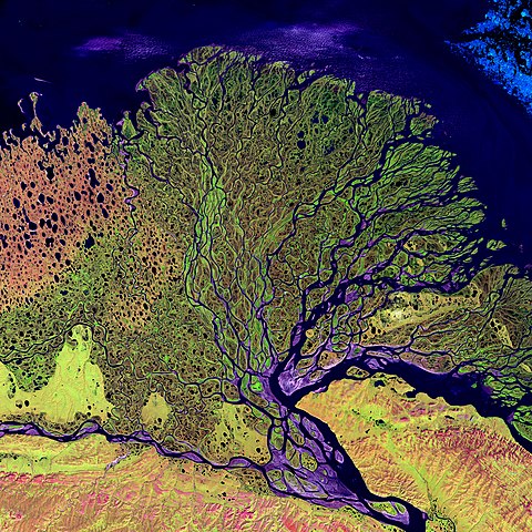
Čeština: Delta Leny.
English: Lena River Delta. False-color composite image made using shortwave infrared, infrared, and red wavelengths.
Deutsch: Lena Delta. Falschfarben-Fotomosaik im Kurzwellen-Infrarot, Infrarot und roten Licht.
Français : Delta du fleuve Lena. Image composite en fausse couleurs représentant le rouge, l'infrarouge proche et l'infrarouge lointain.
Ελληνικά: Το δέλτα του ποταμού Λένα της Ρωσίας όπως το απεικόνισε ο δορυφόρος Landsat το 2000
Türkçe: Lena Nehri sularını Yeni Sibirya Adaları'nın kuzeybatısına 10,800 km²lik bir delta ile bırakır. Nehir ağzının delta boyunca uzunluğu 400 km. yi bulmaktadır. Delta alanının bir kısmı Vahşî Yaşamı Koruma Bölgesi ilân edilmiştir. (Lena Nehri Deltasının Uydu Görüntüsü - Landsat 2000) |
| 日期 | |
| 來源 |
http://visibleearth.nasa.gov/view_detail.php?id=3451
|
| 作者 | none (Landsat) |
| 其他版本 | See also: http://landsat.gsfc.nasa.gov/earthasart/lena.html |
授權條款
| 本作品由NASA創作,屬於公有領域。根據NASA的版權政策:“NASA的創作除非另有聲明否則不受版權保護。”(參見:Template:PD-USGov/zh,NASA版權政策或JPL圖像使用政策) | ||
 |
警告:
|
評價
|

This image was selected as picture of the day on Wikimedia Commons for 7 November 2006. It was captioned as follows: English: Lena River Delta Other languages:
Čeština: Delta řeky Leny Cymraeg: Delta yr Afon Lena, gogledd Rwsia (delwedd lloeren). Deutsch: Satellitenbild des Lena-Deltas English: Lena River Delta Magyar: A Léna folyó deltája (infravörös, műholdas kép) Norsk nynorsk: Deltaet til elva Lena. Svenska: Floden Lenas delta. Türkçe: Lena Deltası Русский: Дельта реки Лена 日本語: レナ川デルタ 中文: 勒拿河口三角洲 |
檔案歷史
點選日期/時間以檢視該時間的檔案版本。
| 日期/時間 | 縮圖 | 尺寸 | 用戶 | 備註 | |
|---|---|---|---|---|---|
| 目前 | 2006年3月9日 (四) 04:26 | | 3,100 × 3,100(4.18 MB) | Überraschungsbilder | *en:Lena River Delta *Source: http://visibleearth.nasa.gov/view_detail.php?id=3451 – http://veimages.gsfc.nasa.gov//3451/landsat_art_lena_lrg.jpg **Visible Earth v1 ID: 18024 **Credit: Image provided by the USGS EROS Data Center Satellite Systems |
檔案用途
下列頁面有用到此檔案:
全域檔案使用狀況
以下其他 wiki 使用了這個檔案:
- af.wikipedia.org 的使用狀況
- als.wikipedia.org 的使用狀況
- ast.wikipedia.org 的使用狀況
- avk.wikipedia.org 的使用狀況
- azb.wikipedia.org 的使用狀況
- az.wikipedia.org 的使用狀況
- az.wiktionary.org 的使用狀況
- Şablon:Portal:Rusiya
- Şablon:Portal:Rusiya/Kateqoriyalar
- Şablon:Portal:Türkiyə
- Şablon:Portal:Türkiyə/Kateqoriyalar
- Şablon:Portal:Azərbaycan
- Şablon:Portal:Azərbaycan/Kateqoriyalar
- Şablon:Portal:Böyük Britaniya
- Şablon:Portal:Böyük Britaniya/Kateqoriyalar
- Portal:Portuqaliya
- Şablon:Portal:Portuqaliya/Kateqoriyalar
- Portal:Almaniya
- Şablon:Portal:Almaniya/Kateqoriyalar
- Portal:Koreya
- Şablon:Portal:Koreya/Kateqoriyalar
- Portal:Ərəb dili
- Şablon:Portal:Ərəb dili/Kateqoriyalar
- Portal:İtaliya
- Şablon:Portal:İtaliya/Kateqoriyalar
- Portal:Yunanıstan
- Şablon:Portal:Yunanıstan/Kateqoriyalar
- Portal:İspaniya
- Şablon:Portal:İspaniya/Kateqoriyalar
- Portal:Fransa
- Şablon:Portal:Fransa/Kateqoriyalar
- Şablon:Portal:Gürcüstan
- Şablon:Portal:Pakistan/Kateqoriyalar
- Portal:Pakistan
- Şablon:Portal:İran/Kateqoriyalar
- Portal:İran
- Şablon:Portal:Gürcüstan/Kateqoriyalar
- ba.wikipedia.org 的使用狀況
檢視此檔案的更多全域使用狀況。