
File:Bassin de l'Authie-fr.svg

此 SVG 檔案的 PNG 預覽的大小:800 × 461 像素。 其他解析度:320 × 184 像素 | 640 × 369 像素 | 1,024 × 590 像素 | 1,280 × 738 像素 | 2,560 × 1,476 像素 | 1,060 × 611 像素。
原始檔案 (SVG 檔案,表面大小:1,060 × 611 像素,檔案大小:1.14 MB)
| 描述 |
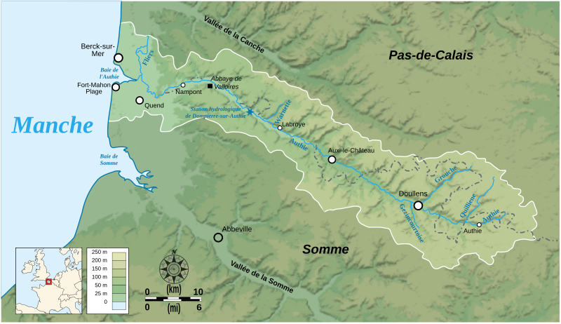
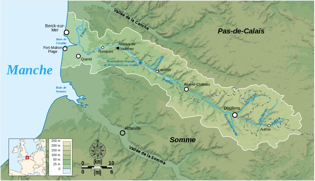
English: Map showing the drainage basin of the Authie river, Picardie, France. Français : Carte du bassin versant de l'Authie, Picardie, France. |
||
| 日期 | |||
| 來源 |
Data sources:
Softwares used: Others:
|
||
| 作者 | Bourrichon | ||
| 授權許可 (重用此檔案) |
此檔案採用共享創意 姓名標示-相同方式分享 3.0 未在地化版本授權條款。
|


|
This SVG file contains embedded text that can be translated into your language, using any capable SVG editor, text editor or the SVG Translate tool. For more information see: About translating SVG files. |
檔案歷史
點選日期/時間以檢視該時間的檔案版本。
| 日期/時間 | 縮圖 | 尺寸 | 用戶 | 備註 | |
|---|---|---|---|---|---|
| 目前 | 2008年2月22日 (五) 18:54 | | 1,060 × 611(1.14 MB) | Bourrichon | correction placement Abbeville + typo |
| 2008年2月22日 (五) 17:01 |  | 1,060 × 611(1.43 MB) | Bourrichon | + taille toponymes et ajout des vallées de la Somme et de la Canche | |
| 2008年2月17日 (日) 01:37 |  | 1,060 × 611(1.44 MB) | Bourrichon | Petites corrections (typo, cadre) | |
| 2008年2月17日 (日) 01:19 |  | 1,060 × 611(1.14 MB) | Bourrichon | + incorporation correcte du bitmap dans le svg | |
| 2008年2月17日 (日) 00:07 |  | 1,060 × 611(136 KB) | Bourrichon | + incorporation du fond bitmap dans le svg | |
| 2008年2月17日 (日) 00:01 |  | 1,060 × 611(136 KB) | Bourrichon | {{Information |Description= {{en}}Map showing the drainage basin of the Authie river, between Picardie and Haute-Normandie, France. {{fr}}Carte du bassin versant de l'Authie, entre la Picardie et la Haute-Normandie, Fra |
檔案用途
下列頁面有用到此檔案:
全域檔案使用狀況
以下其他 wiki 使用了這個檔案:
- de.wikipedia.org 的使用狀況
- en.wikipedia.org 的使用狀況
- es.wikipedia.org 的使用狀況
- et.wikipedia.org 的使用狀況
- fr.wikipedia.org 的使用狀況
- it.wikipedia.org 的使用狀況
- nn.wikipedia.org 的使用狀況
- pcd.wikipedia.org 的使用狀況
- pl.wikipedia.org 的使用狀況
- ru.wikipedia.org 的使用狀況
- sr.wikipedia.org 的使用狀況
- www.wikidata.org 的使用狀況