
File:Americas independence map.PNG

預覽大小:407 × 600 像素。 其他解析度:163 × 240 像素 | 326 × 480 像素 | 862 × 1,270 像素。
原始檔案 (862 × 1,270 像素,檔案大小:74 KB,MIME 類型:image/png)

|
本圖片是以PNG、GIF或JPEG格式上傳。然而,其中包含的資料或訊息,應該重新建立成可縮放向量圖形(SVG)檔案,以更有效率或更準確的方式儲存。如有可能,請上傳本圖片的SVG格式版本。在上傳之後,請修改維基各姊妹計畫中所有使用舊版圖片的條目(列在圖像連結章節中),替換為新版圖片,並在舊圖片的描述頁中加入{{Vector version available|新圖片名稱.svg}}模板,同時移除本模板。
|
摘要
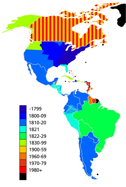
Map showing date of independence of country in the Americas. Black shows areas not yet independent.
Uses current boundaries, which may not correspond with the historical boundary of the country when it became independent. For example the United States was composed of 13 states on the East Coast when it became independent and did not reach its full continental extant until 1867 with the .
授權條款

|
已授權您依據自由軟體基金會發行的無固定段落、封面文字和封底文字GNU自由文件授權條款1.2版或任意後續版本,對本檔進行複製、傳播和/或修改。該協議的副本列在GNU自由文件授權條款中。 |
| 此檔案採用共享創意 姓名標示-相同方式分享 3.0 未在地化版本授權條款。 | ||
| ||
| 已新增授權條款標題至此檔案,作為GFDL授權更新的一部份。 |
檔案歷史
點選日期/時間以檢視該時間的檔案版本。
| 日期/時間 | 縮圖 | 尺寸 | 用戶 | 備註 | |
|---|---|---|---|---|---|
| 目前 | 2019年5月11日 (六) 14:23 | | 862 × 1,270(74 KB) | Foghe | Removed Labrador border; only current international borders. |
| 2019年4月25日 (四) 03:32 |  | 862 × 1,270(44 KB) | Marcomogollon | I add disputed territory between Colombia, Ecuador and Peru | |
| 2011年10月3日 (一) 23:11 |  | 862 × 1,270(68 KB) | Lemonade100 | Added some current dependent territories and re-coded Canada - gained sovereignty in 1939 and full independence in 1982. | |
| 2010年11月9日 (二) 18:35 |  | 862 × 1,270(38 KB) | Minnecologies | Fixed error in northern Canada | |
| 2010年11月9日 (二) 17:25 |  | 862 × 1,270(38 KB) | Minnecologies | *Filled in Pacific Northwest *Added Saint Pierre and Miquelon *Updated the boundaries of Gran Colombia, Bolivia, and Peru *Changed color scheme to straight ROYGBIV | |
| 2007年8月20日 (一) 06:32 |  | 862 × 1,270(61 KB) | AlexCovarrubias | Mexico independence year is 1810 | |
| 2006年12月7日 (四) 00:48 |  | 862 × 1,270(49 KB) | Roke~commonswiki | include colonies | |
| 2006年3月22日 (三) 12:48 |  | 862 × 1,270(63 KB) | Roke~commonswiki | Map showing date of independence of country in the Americas Category: America |
檔案用途
下列頁面有用到此檔案:
全域檔案使用狀況
以下其他 wiki 使用了這個檔案:
- ar.wikipedia.org 的使用狀況
- bg.wikipedia.org 的使用狀況
- cs.wikipedia.org 的使用狀況
- de.wikipedia.org 的使用狀況
- en.wikipedia.org 的使用狀況
- es.wikipedia.org 的使用狀況
- fa.wikipedia.org 的使用狀況
- fi.wikipedia.org 的使用狀況
- fr.wikipedia.org 的使用狀況
- fy.wikipedia.org 的使用狀況
- gl.wikipedia.org 的使用狀況
- ja.wikipedia.org 的使用狀況
- kn.wikipedia.org 的使用狀況
- ms.wikipedia.org 的使用狀況
- nds-nl.wikipedia.org 的使用狀況
- nl.wikipedia.org 的使用狀況
- pt.wikipedia.org 的使用狀況
- sd.wikinews.org 的使用狀況
- uk.wikipedia.org 的使用狀況
- www.wikidata.org 的使用狀況
- wo.wikipedia.org 的使用狀況