
File:Snow-cholera-map-1.jpg

預覽大小:639 × 599 像素。 其他解析度:256 × 240 像素 | 512 × 480 像素 | 819 × 768 像素 | 1,092 × 1,024 像素 | 2,183 × 2,048 像素 | 20,124 × 18,877 像素。
原始檔案 (20,124 × 18,877 像素,檔案大小:18.38 MB,MIME 類型:image/jpeg)
摘要
| 警告 | 部分瀏覽器在瀏覽此圖片的完整大小時可能會遇到困難:該圖片中有數量巨大的像素點,可能無法完全載入或者導致您的瀏覽器停止回應。 |
|---|
| 描寫 |
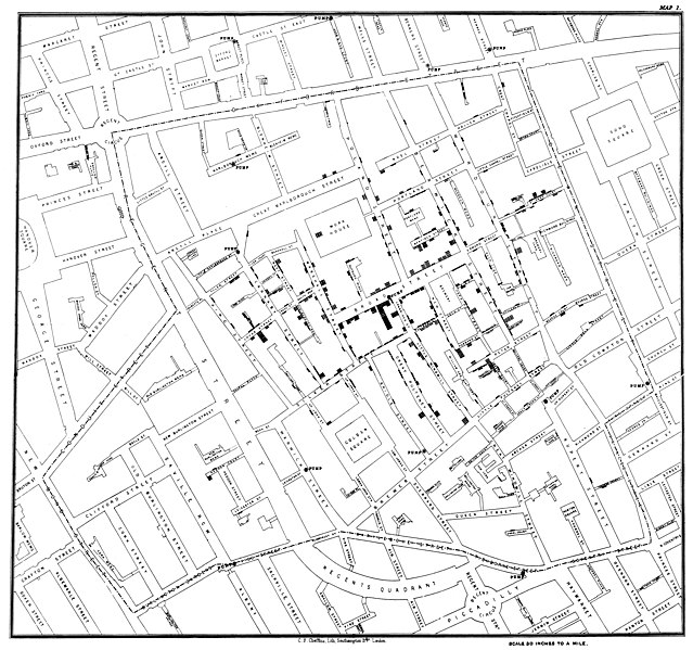
Original map made by John Snow in 1854. Cholera cases are highlighted in black, showing the clusters of cholera cases (indicated by stacked rectangles) in the London epidemic of 1854. The map was created in order to better understand the pattern of cholera spread in the 1854 Broad Street cholera outbreak, which Snow would use as an example of how cholera spread via the fecal-oral route through water systems as opposed to the miasma theory of disease spread. The contaminated pump is located at the intersection of Broad Street and Cambridge Street (now Lexington Street), running into Little Windmill Street. The map marks an important part of the development of epidemiology as a field, and of disease mapping as a whole. |
|||||||||
| 日期 | ||||||||||
| 來源 |
Map of the book "On the Mode of Communication of Cholera" by John Snow, originally published in 1854 by C.F. Cheffins, Lith, Southhampton Buildings, London, England. The uploaded images is a digitally enhanced version found on the UCLA Department of Epidemiology website. |
|||||||||
| 創作作者 | ||||||||||
| Geotemporal data | ||||||||||
| 邊框 |
|
|||||||||
| 地理參考 | ||||||||||
| 其他版本 | File:Snow-cholera-map.jpg | |||||||||

|
授權條款
|
此為如實地拍攝平面藝術品的相片複製本。原作位於公有領域,是因下列原因:
維基媒體基金會的官方立場認為:「針對平面公有領域的藝術作品進行忠實重製,其重製後的照片也屬於公有領域。」
因此,可認定本重製照片屬於公有領域。在其他司法管轄區,再利用此照片可能會被限制;參見再利用PD-Art照片以獲得進一步資訊。 | ||||
原始上傳日誌
(All user names refer to en.wikipedia)
- 2006-12-30 23:15 Rewardiv 3045×2840×8 (1183741 bytes) Original map made by John Snow in 1854, copied from http://matrix.msu.edu/~johnsnow/images/online_companion/chapter_images/fig12-5.jpg Author died in 1858, material is public domain.
檔案歷史
點選日期/時間以檢視該時間的檔案版本。
| 日期/時間 | 縮圖 | 尺寸 | 用戶 | 備註 | |
|---|---|---|---|---|---|
| 目前 | 2020年11月16日 (一) 21:19 | | 20,124 × 18,877(18.38 MB) | Artoria2e5 | Reverted to version as of 14:12, 6 May 2020 (UTC) |
| 2020年11月16日 (一) 21:12 |  | 1,092 × 1,024(320 KB) | Artoria2e5 | temporarily reduce size for wikimaps | |
| 2020年5月6日 (三) 14:12 |  | 20,124 × 18,877(18.38 MB) | Sette-quattro | higher resolution version | |
| 2007年6月22日 (五) 13:53 |  | 3,045 × 2,840(1.13 MB) | Finavon | {{Information |Description=Original map made by John Snow in 1854, copied from http://matrix.msu.edu/~johnsnow/images/online_companion/chapter_images/fig12-5.jpg Author died in 1858, material is public domain. |Source=Originally from [http://en.wikipedi |
檔案用途
下列5個頁面有用到此檔案:
全域檔案使用狀況
以下其他 wiki 使用了這個檔案:
- ar.wikipedia.org 的使用狀況
- bg.wikipedia.org 的使用狀況
- bh.wikipedia.org 的使用狀況
- bn.wikipedia.org 的使用狀況
- ca.wikipedia.org 的使用狀況
- de.wikipedia.org 的使用狀況
- de.wikiversity.org 的使用狀況
- en.wikipedia.org 的使用狀況
- Human geography
- Natural experiment
- Water purification
- Public health
- John Snow
- Slow sand filter
- Portal:Medicine
- Health geography
- Thematic map
- User talk:Mathwhiz 29
- Statistical graphics
- Wikipedia:Featured pictures/Diagrams, drawings, and maps/Maps
- 1846–1860 cholera pandemic
- 1854 Broad Street cholera outbreak
- Talk:1854 Broad Street cholera outbreak
- User:Aetarrell/Practice
- GIS and public health
- Wikipedia:WikiProject Medicine/Recognized content
- Dot distribution map
- History of water filters
- Wikipedia:Reference desk/Archives/Humanities/2010 August 24
- History of water supply and sanitation
- User talk:Sarason
- Portal:Geography/Intro/Image
- User talk:Smileguy91
- User:Life in General/Userboxes/HumanGeography
- User talk:Gwooodward
- Portal:Geography/Intro/6
- User:Wouterstomp/test
- Charles Cheffins
- User talk:Khamar
- User talk:Joshualouie711
- User talk:OfficialNeon
- User talk:Sahara4u/Archive 5
檢視此檔案的更多全域使用狀況。