
File:Cicer distribution map.png
預覽大小:800 × 480 像素。 其他解析度:320 × 192 像素。
原始檔案 (1,000 × 600 像素,檔案大小:473 KB,MIME 類型:image/png)
摘要
| 描述 |
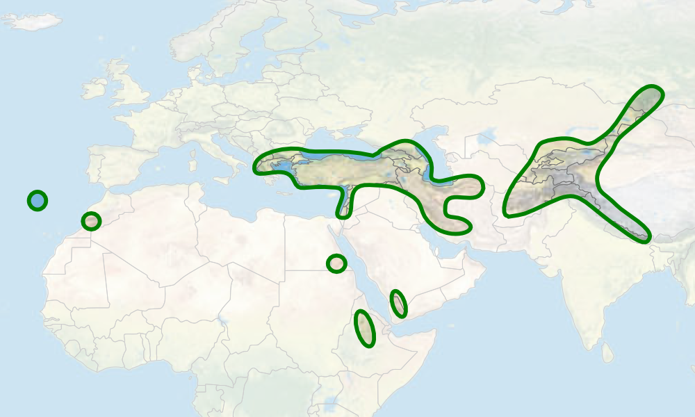
English: Range map of the genus Cicer using data from van der Maesen et al (2007): Taxonomy of the genus Cicer revisited. |
| 日期 | |
| 來源 |
自己的作品 using world map from [1] by Tom Patterson, US National Park Service (public domain) |
| 作者 | Dietzel |
授權條款
| 我,此作品的版權所有人,釋出此作品至公共領域。此授權條款在全世界均適用。 這可能在某些國家不合法,如果是的話: 我授予任何人有權利使用此作品於任何用途,除受法律約束外,不受任何限制。 |
檔案歷史
點選日期/時間以檢視該時間的檔案版本。
| 日期/時間 | 縮圖 | 尺寸 | 用戶 | 備註 | |
|---|---|---|---|---|---|
| 目前 | 2010年6月25日 (五) 18:59 | | 1,000 × 600(473 KB) | Dietzel | {{Information |Description={{en|1=Range map of the genus ''Cicer'' using data from van der Maesen et al (2007): ''Taxonomy of the genus Cicer revisited''.}} |Source={{own}} using world map from [http://www.shadedrelief.com] by Tom Patterson, US National P |
檔案用途
下列頁面有用到此檔案:
全域檔案使用狀況
以下其他 wiki 使用了這個檔案:
- ar.wikipedia.org 的使用狀況
- arz.wikipedia.org 的使用狀況
- ca.wikipedia.org 的使用狀況
- cs.wikipedia.org 的使用狀況
- de.wikipedia.org 的使用狀況
- en.wikipedia.org 的使用狀況
- en.wiktionary.org 的使用狀況
- es.wikipedia.org 的使用狀況
- eu.wikipedia.org 的使用狀況
- hr.wikipedia.org 的使用狀況
- hy.wikipedia.org 的使用狀況
- it.wikipedia.org 的使用狀況
- la.wikipedia.org 的使用狀況
- mk.wikipedia.org 的使用狀況
- os.wikipedia.org 的使用狀況
- pt.wikipedia.org 的使用狀況
- ru.wikipedia.org 的使用狀況
- species.wikimedia.org 的使用狀況
- sv.wikipedia.org 的使用狀況
- tr.wikipedia.org 的使用狀況
- uk.wikipedia.org 的使用狀況
- vi.wikipedia.org 的使用狀況
- www.wikidata.org 的使用狀況