
File:Antalya districts.png
預覽大小:736 × 599 像素。 其他解析度:295 × 240 像素 | 589 × 480 像素 | 954 × 777 像素。
原始檔案 (954 × 777 像素,檔案大小:46 KB,MIME 類型:image/png)
摘要
| 描述 |
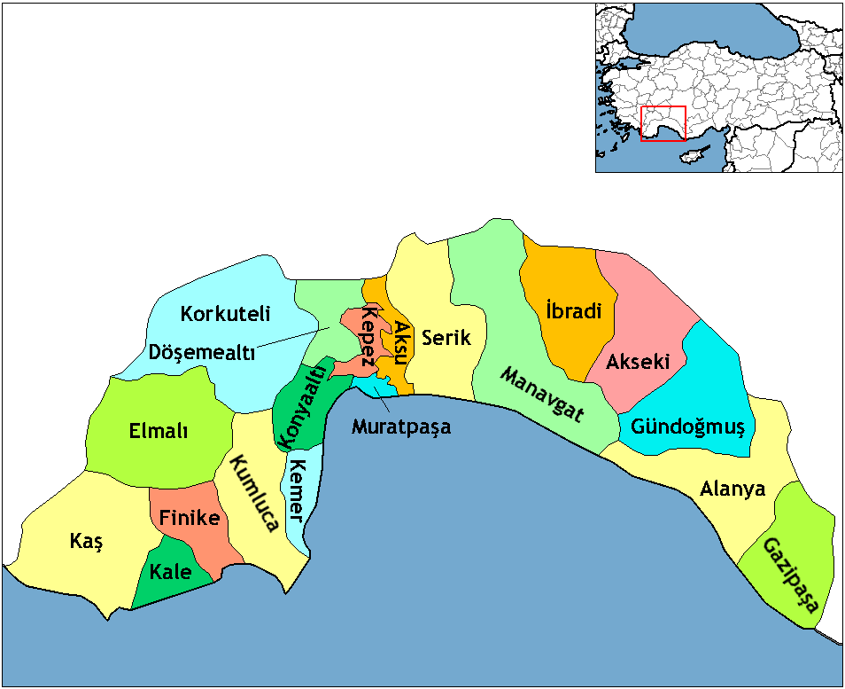
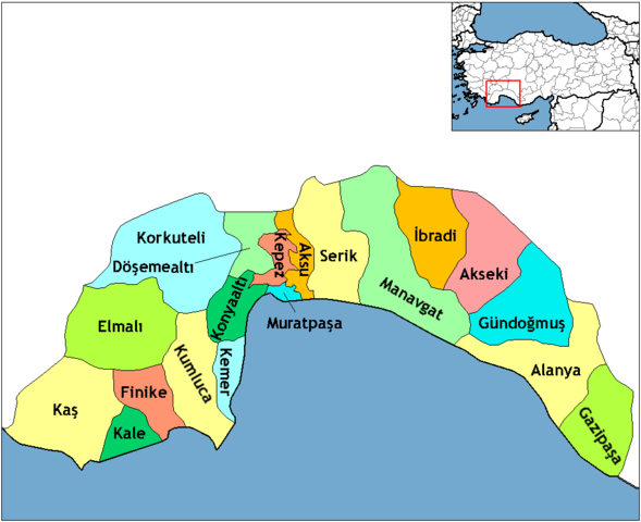
English: Map of the districts of Antalya province in Turkey. Created by Rarelibra 16:59, 1 December 2006 (UTC) for public domain use, using MapInfo Professional v8.5 and various mapping resources. Edited by One Homo Sapiens Corrected text where İ,Ş,ı,ğ,or ş occurs in name. Source: [statoids-com]. Increased font size and enhanced color differences among adjacent districts. |
| 日期 | 2006年十二月1日 (原始上傳日期) |
| 來源 | 无法识别来源。根据版权声明推断为其自己的作品。 |
| 作者 | 无法识别作者。根据版权声明推断作者为Rarelibra。 |
授權條款
| 我,此作品的版權所有人,釋出此作品至公共領域。此授權條款在全世界均適用。 這可能在某些國家不合法,如果是的話: 我授予任何人有權利使用此作品於任何用途,除受法律約束外,不受任何限制。 |
This image was intentionally uploaded with a border. Please do not remove the border. Upload a new version under a different filename without a border if you want a version without a border.
|
檔案歷史
點選日期/時間以檢視該時間的檔案版本。
| 日期/時間 | 縮圖 | 尺寸 | 用戶 | 備註 | |
|---|---|---|---|---|---|
| 目前 | 2018年2月18日 (日) 23:24 | | 954 × 777(46 KB) | Effeietsanders | Removed border by cropping 10 % horizontally and 5 % vertically using CropTool with precise mode. |
| 2009年1月1日 (四) 19:18 |  | 1,056 × 816(67 KB) | Onur | {{Information |Description= |Source= |Date= |Author= |Permission= |other_versions= }} | |
| 2008年12月28日 (日) 20:43 |  | 1,056 × 816(39 KB) | One Homo Sapiens | Corrected text where İ,Ş,ı,ğ,or ş occurs in name. Source: [statoids-com]. Increased font size and enhanced color differences among adjacent districts. | |
| 2006年12月1日 (五) 16:59 |  | 1,056 × 816(32 KB) | Rarelibra | Map of the districts of Antalya province in Turkey. Created by ~~~~ for public domain use, using MapInfo Professional v8.5 and various mapping resources. |
檔案用途
下列頁面有用到此檔案:
全域檔案使用狀況
以下其他 wiki 使用了這個檔案:
- azb.wikipedia.org 的使用狀況
- az.wikipedia.org 的使用狀況
- ba.wikipedia.org 的使用狀況
- be.wikipedia.org 的使用狀況
- br.wikipedia.org 的使用狀況
- ca.wikipedia.org 的使用狀況
- da.wikipedia.org 的使用狀況
- de.wikipedia.org 的使用狀況
- Alanya
- Antalya (Provinz)
- Gazipaşa
- Akseki
- Kumluca (Antalya)
- Vorlage:Navigationsleiste Landkreise der Provinz Antalya
- Serik (Landkreis)
- Korkuteli (Landkreis)
- Finike (Landkreis)
- Elmalı (Landkreis)
- İbradı (Landkreis)
- Kemer (Landkreis, Antalya)
- Kaş (Landkreis)
- Gündoğmuş
- Demre
- Aksu (Antalya)
- Döşemealtı
- Kepez (Antalya)
- Konyaaltı
- Muratpaşa
- diq.wikipedia.org 的使用狀況
- en.wikipedia.org 的使用狀況
檢視此檔案的更多全域使用狀況。