
File:Recreation ground on the Isle of Raasay - geograph.org.uk - 1476596.jpg
無更高解析度可提供。
Recreation_ground_on_the_Isle_of_Raasay_-_geograph.org.uk_-_1476596.jpg (640 × 480 像素,檔案大小:108 KB,MIME 類型:image/jpeg)
摘要
| 描述 |
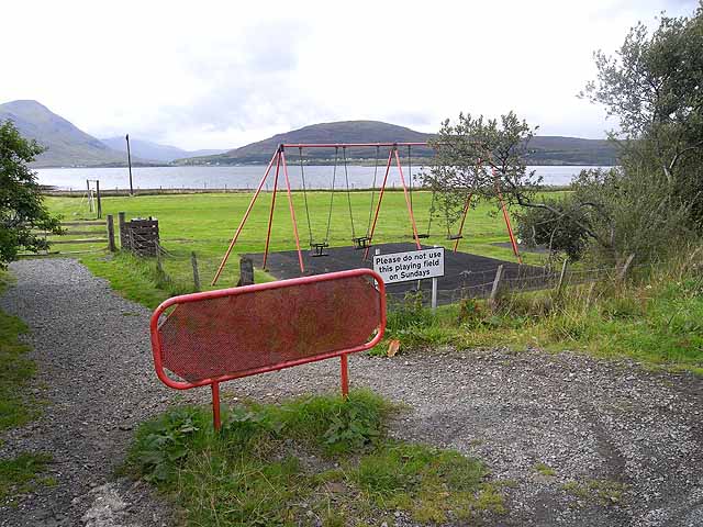
English: Recreation ground on the Isle of Raasay There is a strong tradition of strict Sunday observance on the islands of Scotland, and this is a matter which provokes strong emotions for many inhabitants. |
| 日期 | |
| 來源 | From geograph.org.uk |
| 作者 | Oliver Dixon |
| 姓名標示 (由许可协议要求) | Oliver Dixon / Recreation ground on the Isle of Raasay / |
| 拍攝地點 | | 位於此地的本圖片與其他圖片: OpenStreetMap |
|---|
_heading:202.00&language=zh-hant)
| 目標地點 | | 位於此地的本圖片與其他圖片: OpenStreetMap |
|---|
_heading:202.00&language=zh-hant)
授權條款

|
此檔案採用創用CC 姓名標示-相同方式分享 2.0 通用版授權條款。
姓名標示: Oliver Dixon
- 您可以自由:
- 分享 – 複製、發佈和傳播本作品
- 重新修改 – 創作演繹作品
- 惟需遵照下列條件:
- 姓名標示 – 您必須指名出正確的製作者,和提供授權條款的連結,以及表示是否有對內容上做出變更。您可以用任何合理的方式來行動,但不得以任何方式表明授權條款是對您許可或是由您所使用。
- 相同方式分享 – 如果您利用本素材進行再混合、轉換或創作,您必須基於如同原先的相同或兼容的條款,來分布您的貢獻成品。
檔案歷史
點選日期/時間以檢視該時間的檔案版本。
| 日期/時間 | 縮圖 | 尺寸 | 使用者 | 備註 | |
|---|---|---|---|---|---|
| 目前 | 2011年3月2日 (三) 12:39 | | 640 × 480(108 KB) | GeographBot | == {{int:filedesc}} == {{Information |description={{en|1=Recreation ground on the Isle of Raasay There is a strong tradition of strict Sunday observance on the islands of Scotland, and this is a matter which provokes strong emotions for many inhabitants. |
檔案用途
下列頁面有用到此檔案:
全域檔案使用狀況
以下其他 wiki 使用了這個檔案:
- de.wikipedia.org 的使用狀況
- en.wikipedia.org 的使用狀況
- es.wikipedia.org 的使用狀況
- fi.wikipedia.org 的使用狀況
- ko.wikipedia.org 的使用狀況
- la.wikipedia.org 的使用狀況
- nl.wikipedia.org 的使用狀況
- pt.wikipedia.org 的使用狀況
- ru.wikipedia.org 的使用狀況
- uk.wikipedia.org 的使用狀況