
File:Macedonia topography-en.svg

原始檔案 (SVG 檔案,表面大小:920 × 652 像素,檔案大小:4.25 MB)
摘要
| 描述 |
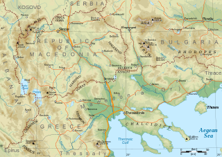
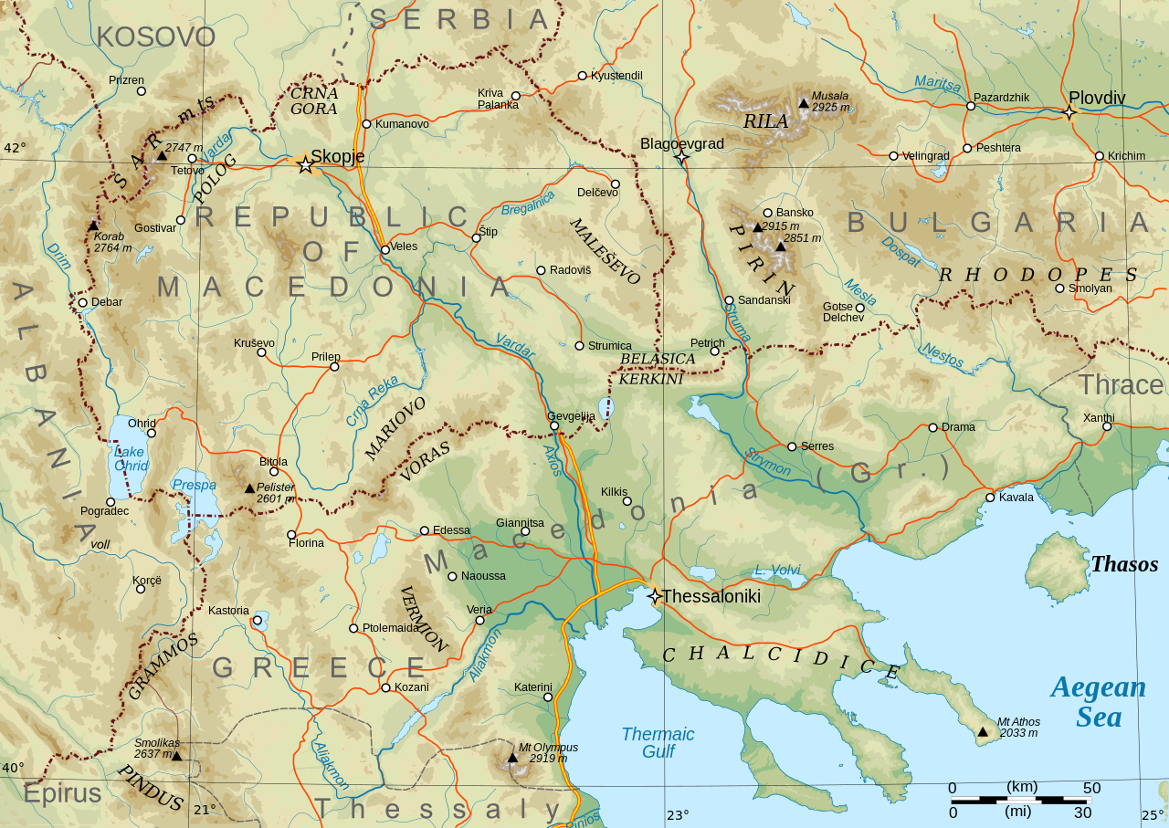
English: Topographical map of Macedonia, i.e. the Republic of North Macedonia, the Greek province of Macedonia, and southwestern Bulgaria. |
| 日期 | |
| 來源 | 自己的作品 |
| 作者 | Future Perfect at Sunrise |
| 其他版本 |
此檔案衍生的作品: Macedonia topography-He.svg This file version has non-horizontal text labels converted to paths, to ensure correct display with renderers that don't do advanced text layout along paths. If you want to modify or translate this map, please work on the basis of File:Macedonia topography (texts).svg, which has the labels preserved as texts (but will only display correctly in Inkscape).
|

.svg)
Made with GRASS GIS and Inkscape software from public-domain geo data (SRTM3, SWBD, VMAP0). See the excellent tutorials by User:Sting at w:fr:Wikipédia:Atelier graphique/Didacticiels cartographiques/Didacticiels pour la cartographie numérique géoréférencée. Relief levels vectorised and exported to SVG; relief shading is embedded bitmap graphics.
Geographical extent: c. 20.5E to 25.3E, 39.8N to 42.4N; map projection: Lambert conformal conic with standard parallels 40 and 42N, standard meridian 23E. Scale approx. 1:1,600,000 at nominal SVG size.
授權條款
| 我,此作品的版權所有人,釋出此作品至公共領域。此授權條款在全世界均適用。 這可能在某些國家不合法,如果是的話: 我授予任何人有權利使用此作品於任何用途,除受法律約束外,不受任何限制。 |
檔案歷史
點選日期/時間以檢視該時間的檔案版本。
| 日期/時間 | 縮圖 | 尺寸 | 使用者 | 備註 | |
|---|---|---|---|---|---|
| 目前 | 2009年1月31日 (六) 08:29 | | 920 × 652(4.25 MB) | Future Perfect at Sunrise | some additions and corrections |
| 2009年1月23日 (五) 21:49 |  | 920 × 652(4.01 MB) | Future Perfect at Sunrise | {{Information |Description={{en|1=Topographical map of geographic Macedonia}} |Source=Own work by uploader |Author=Future Perfect at Sunrise |Date=23 January 2009 |Permission= |other_versions= }} <!--{{ImageUpload|full} |
檔案用途
下列頁面有用到此檔案:
全域檔案使用狀況
以下其他 wiki 使用了這個檔案:
- ang.wikipedia.org 的使用狀況
- ar.wikipedia.org 的使用狀況
- ca.wikipedia.org 的使用狀況
- el.wikipedia.org 的使用狀況
- en.wikipedia.org 的使用狀況
- fa.wikipedia.org 的使用狀況
- fi.wikipedia.org 的使用狀況
- fr.wikipedia.org 的使用狀況
- he.wikipedia.org 的使用狀況
- id.wikipedia.org 的使用狀況
- it.wikipedia.org 的使用狀況
- ja.wikipedia.org 的使用狀況
- ms.wikipedia.org 的使用狀況
- pl.wikipedia.org 的使用狀況
- sq.wikipedia.org 的使用狀況
- sr.wikipedia.org 的使用狀況
- sw.wikipedia.org 的使用狀況
- trv.wikipedia.org 的使用狀況
- war.wikipedia.org 的使用狀況
- zh-yue.wikipedia.org 的使用狀況