
File:Iditarod Trail BLM map.jpg
無更高解析度可提供。
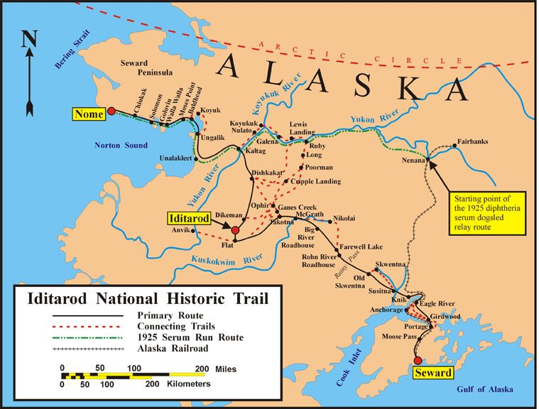
Iditarod_Trail_BLM_map.jpg (759 × 576 像素,檔案大小:85 KB,MIME 類型:image/jpeg)
摘要
| 描述 | Map of the historical Iditarod Trail and the current Iditarod National Historic Trail in Alaska, USA |
| 日期 | |
| 來源 | U.S. Bureau of Land Management |
| 作者 | U.S. Bureau of Land Management |
| 授權許可 (重用此檔案) |
public domain, as a U.S. federal government work |

|
本圖片是以PNG、GIF或JPEG格式上傳。然而,其中包含的資料或訊息,應該重新建立成可縮放向量圖形(SVG)檔案,以更有效率或更準確的方式儲存。如有可能,請上傳本圖片的SVG格式版本。在上傳之後,請修改維基各姊妹計畫中所有使用舊版圖片的條目(列在圖像連結章節中),替換為新版圖片,並在舊圖片的描述頁中加入{{Vector version available|新圖片名稱.svg}}模板,同時移除本模板。
|


授權條款
| This image is a work of a Bureau of Land Management* employee, taken or made as part of that person's official duties. As a work of the U.S. federal government, the image is in the public domain in the United States. *or predecessor organization |
檔案歷史
點選日期/時間以檢視該時間的檔案版本。
| 日期/時間 | 縮圖 | 尺寸 | 使用者 | 備註 | |
|---|---|---|---|---|---|
| 目前 | 2008年2月9日 (六) 05:47 | | 759 × 576(85 KB) | Delirium | {{Information |Description=Map of the historical Iditarod Trail and the current Iditarod National Historic Trail in Alaska, USA |Source=[http://www.blm.gov/ak/st/en/prog/sa/iditarod/inht_map.html U.S. Bureau of Land Management] |Date=2007 |Author=U.S. Bur |
檔案用途
下列頁面有用到此檔案:
全域檔案使用狀況
以下其他 wiki 使用了這個檔案:
- az.wikipedia.org 的使用狀況
- cs.wikipedia.org 的使用狀況
- de.wikipedia.org 的使用狀況
- en.wikipedia.org 的使用狀況
- en.wikivoyage.org 的使用狀況
- es.wikipedia.org 的使用狀況
- fr.wikipedia.org 的使用狀況
- Iditarod Trail
- Course au sérum de 1925
- Discussion:Course au sérum de 1925
- Wikipédia:Le saviez-vous ?/Archives/2015
- Utilisateur:GhosterBot/BacASable/testStat/Visibilité des anecdotes (2015)
- Utilisateur:GhosterBot/BacASable/testStat/Visibilité des anecdotes (2015)/2015 02
- Wikipédia:Statistiques des anecdotes de la page d'accueil/Visibilité des anecdotes (2015)/2015 02
- Wikipédia:Statistiques des anecdotes de la page d'accueil/Visibilité des anecdotes (2015)
- Discussion:Course au sérum de 1925/LSV 16741
- he.wikipedia.org 的使用狀況
- id.wikipedia.org 的使用狀況
- it.wikipedia.org 的使用狀況
- ms.wikipedia.org 的使用狀況
- nl.wikipedia.org 的使用狀況
- pl.wikipedia.org 的使用狀況
- ru.wikipedia.org 的使用狀況
- simple.wikipedia.org 的使用狀況
- uk.wikipedia.org 的使用狀況
- uz.wikipedia.org 的使用狀況
- vi.wikipedia.org 的使用狀況
- www.wikidata.org 的使用狀況