
File:Griechischen und phönizischen Kolonien.jpg
預覽大小:800 × 456 像素。 其他解析度:320 × 182 像素 | 640 × 365 像素 | 1,024 × 583 像素 | 1,280 × 729 像素 | 2,836 × 1,616 像素。
原始檔案 (2,836 × 1,616 像素,檔案大小:1.73 MB,MIME 類型:image/jpeg)
摘要
| 描述 |
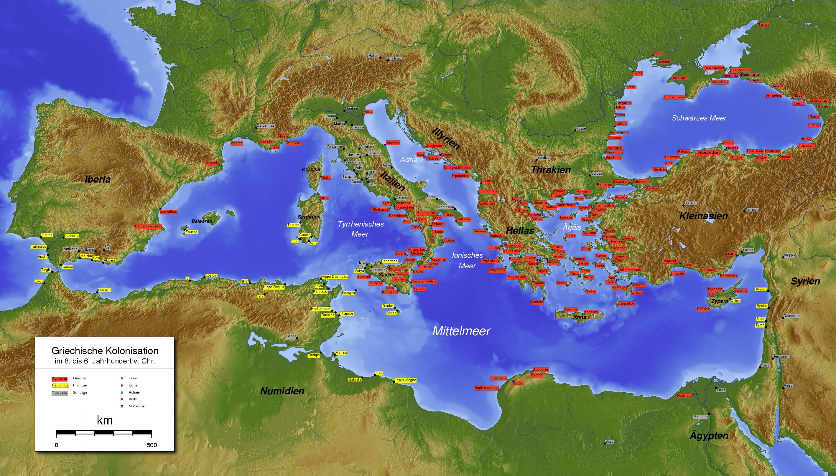
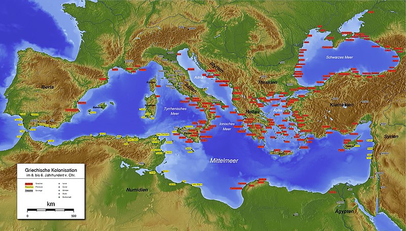
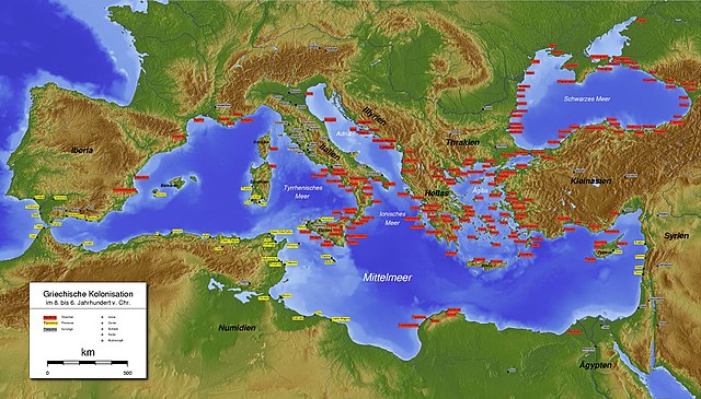
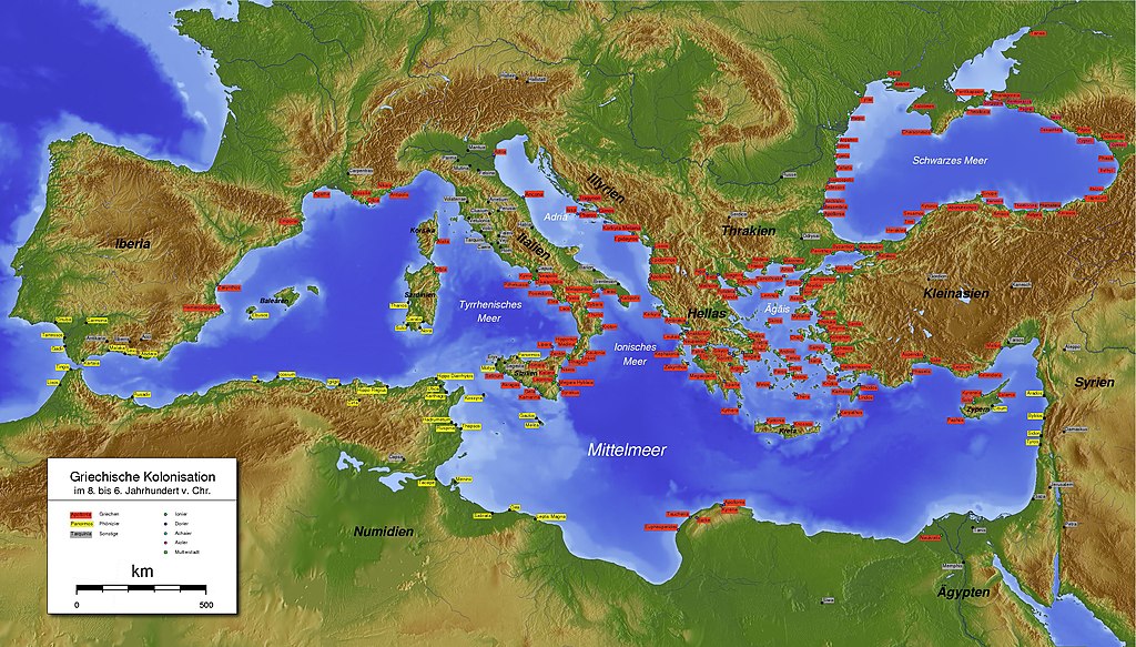
Español: Mapa completo de las colonias griegas y púnicas en el siglo IV a. C. en la cuenca de mediterráneo.
Italiano: La carta completa quella analoga, già presente in Commons, aggiungendo le colonie greche dell'Adriatico, che non erano presenti. La situazione rappresentata è quella del IV secolo a.C. Deutsch: Aktualisieren. Griechischen und phönizischen Kolonien im vierten Jahrhundert v. Chr. Ελληνικά: Υπόμνημα: ελληνικές και φοινικικές αποικίες στον τέταρτο αιώνα π.Χ. English: Greek and Phoenician colonies in the fourth century BC. The map from which it was drawn illustrates the situation in previous centuries. |
| 日期 | |
| 來源 | 自己的作品 |
| 作者 | Gepgepgep |
授權條款
我,本作品的著作權持有者,決定用以下授權條款發佈本作品:
此檔案採用創用CC 姓名標示-相同方式分享 3.0 未在地化版本授權條款。
- 您可以自由:
- 分享 – 複製、發佈和傳播本作品
- 重新修改 – 創作演繹作品
- 惟需遵照下列條件:
- 姓名標示 – 您必須指名出正確的製作者,和提供授權條款的連結,以及表示是否有對內容上做出變更。您可以用任何合理的方式來行動,但不得以任何方式表明授權條款是對您許可或是由您所使用。
- 相同方式分享 – 如果您利用本素材進行再混合、轉換或創作,您必須基於如同原先的相同或兼容的條款,來分布您的貢獻成品。
檔案歷史
點選日期/時間以檢視該時間的檔案版本。
| 日期/時間 | 縮圖 | 尺寸 | 使用者 | 備註 | |
|---|---|---|---|---|---|
| 目前 | 2022年1月24日 (一) 19:30 | | 2,836 × 1,616(1.73 MB) | Maisrimer | See discussion file please |
| 2014年12月1日 (一) 15:12 |  | 2,836 × 1,616(1.84 MB) | Gts-tg | Fixed a couple of small errors | |
| 2013年8月8日 (四) 09:47 |  | 2,836 × 1,616(1.82 MB) | קובי כרמל | Reverted to version as of 10:06, 27 December 2012 | |
| 2013年8月8日 (四) 09:22 |  | 2,836 × 1,616(1.34 MB) | קובי כרמל | Transalation | |
| 2012年12月27日 (四) 10:06 |  | 2,836 × 1,616(1.82 MB) | Gepgepgep | User created page with UploadWizard |
檔案用途
下列頁面有用到此檔案:
全域檔案使用狀況
以下其他 wiki 使用了這個檔案:
- af.wikipedia.org 的使用狀況
- als.wikipedia.org 的使用狀況
- ast.wikipedia.org 的使用狀況
- azb.wikipedia.org 的使用狀況
- ba.wikipedia.org 的使用狀況
- bcl.wikipedia.org 的使用狀況
- be.wikipedia.org 的使用狀況
- ca.wikipedia.org 的使用狀況
- cs.wikipedia.org 的使用狀況
- de.wikipedia.org 的使用狀況
- el.wikipedia.org 的使用狀況
- en.wikipedia.org 的使用狀況
- en.wikisource.org 的使用狀況
- es.wikipedia.org 的使用狀況
檢視此檔案的更多全域使用狀況。