
File:Europe and the Near East at 476 AD.png

預覽大小:800 × 556 像素。 其他解析度:320 × 222 像素 | 640 × 445 像素 | 1,024 × 712 像素 | 1,280 × 890 像素 | 2,830 × 1,967 像素。
原始檔案 (2,830 × 1,967 像素,檔案大小:1.58 MB,MIME 類型:image/png)

|
本圖片是以PNG、GIF或JPEG格式上傳。然而,其中包含的資料或訊息,應該重新建立成可縮放向量圖形(SVG)檔案,以更有效率或更準確的方式儲存。如有可能,請上傳本圖片的SVG格式版本。在上傳之後,請修改維基各姊妹計畫中所有使用舊版圖片的條目(列在圖像連結章節中),替換為新版圖片,並在舊圖片的描述頁中加入{{Vector version available|新圖片名稱.svg}}模板,同時移除本模板。
|
摘要
| 描述 |
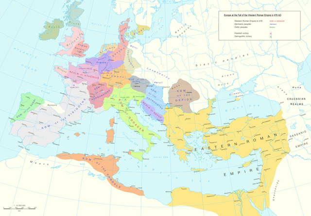
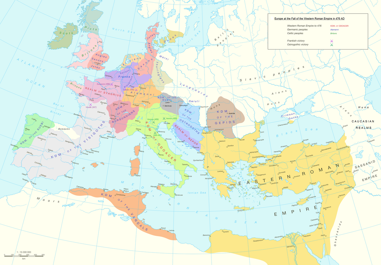
English: Political division in Europe, North Africa and Near East after the end of the Western Roman Empire in 476 AD. Romance area added since H. M. Glessegen (dir.), Handbuch der Romanische Sprachgeschichte, Berlin/New York, p. 544-555. Modified Gaëls / Picts / Britons (see discussion file).
Español: Mapa político de Europa, el Norte de África y Oriente Próximo tras el fin del Imperio Romano de Occidente en 476 d.C. Área románica añadida desde H. M. Glessegen (dir.), Handbuch der Romanische Sprachgeschichte, Berlín/Nueva York, p. 544-555. Gaëls / Pictos / Británicos modificados (ver archivo de discusión).
Français : L'Europe, l'Afrique du Nord et le Proche-Orient après la fin de l'Empire romain d'Occident en 476. Limites des langues romanes ajoutées d'après H. M. Glessegen (dir.), Handbuch der Romanische Sprachgeschichte, Berlin/New York, p. 544-555. Modifié les Gaëls / Pictes / Bretons d'après la page de discussion. |
| 日期 | |
| 來源 | Putzger Historischer Weltatlas, Cornelsen, Berlin 1992 國際標準書號 3-464-00176-8, pp. 34-35 (maps by R. Hachmann). |
| 作者 | Guriezous |
| 授權許可 (重用此檔案) |
自己的作品 |
授權條款
我,本作品的著作權持有者,決定用以下授權條款發佈本作品:
此檔案採用創用CC 姓名標示-相同方式分享 4.0 國際授權條款。
- 您可以自由:
- 分享 – 複製、發佈和傳播本作品
- 重新修改 – 創作演繹作品
- 惟需遵照下列條件:
- 姓名標示 – 您必須指名出正確的製作者,和提供授權條款的連結,以及表示是否有對內容上做出變更。您可以用任何合理的方式來行動,但不得以任何方式表明授權條款是對您許可或是由您所使用。
- 相同方式分享 – 如果您利用本素材進行再混合、轉換或創作,您必須基於如同原先的相同或兼容的條款,來分布您的貢獻成品。
檔案歷史
點選日期/時間以檢視該時間的檔案版本。
| 日期/時間 | 縮圖 | 尺寸 | 使用者 | 備註 | |
|---|---|---|---|---|---|
| 目前 | 2023年10月5日 (四) 12:14 | | 2,830 × 1,967(1.58 MB) | GPinkerton | Reverted to version as of 03:35, 9 January 2022 (UTC) this manipulation of maps is forbidden COM:CROP |
| 2023年9月24日 (日) 09:47 |  | 2,830 × 1,967(1.79 MB) | Claude Zygiel | Add details romance languages of the time according with the article "Romance languages" | |
| 2023年9月22日 (五) 16:52 |  | 2,830 × 1,967(1.78 MB) | Claude Zygiel | Gaëls. All germanic peoples colored. Romance area added since H. M. Glessegen (dir.), {{de}} ''Handbuch der Romanische Sprachgeschichte'', Berlin/New York, p. 544-555. | |
| 2022年1月9日 (日) 03:35 |  | 2,830 × 1,967(1.58 MB) | Jul059 | Lossless file size reduction | |
| 2016年5月7日 (六) 15:33 |  | 2,830 × 1,967(2.2 MB) | Guriezous | Eliminados nombres | |
| 2016年5月5日 (四) 20:08 |  | 2,830 × 1,967(2.21 MB) | Guriezous | Añadidos nombres. | |
| 2016年5月4日 (三) 17:43 |  | 2,830 × 1,967(2.2 MB) | Guriezous | Eliminados nombres rezagados. | |
| 2016年4月24日 (日) 08:52 |  | 2,830 × 1,967(2.21 MB) | Guriezous | Eliminados nombres de provincias en gran parte aleatorias | |
| 2016年4月16日 (六) 10:12 |  | 2,830 × 1,967(2.29 MB) | Guriezous | Eliminada Austrasia | |
| 2016年4月16日 (六) 10:11 |  | 2,830 × 1,967(2.29 MB) | Guriezous | Eliminada Austrasia |
檔案用途
全域檔案使用狀況
以下其他 wiki 使用了這個檔案:
- ar.wikipedia.org 的使用狀況
- ast.wikipedia.org 的使用狀況
- azb.wikipedia.org 的使用狀況
- bg.wikipedia.org 的使用狀況
- bn.wikipedia.org 的使用狀況
- ca.wikipedia.org 的使用狀況
- cs.wikipedia.org 的使用狀況
- de.wikipedia.org 的使用狀況
- de.wikibooks.org 的使用狀況
- de.wikiversity.org 的使用狀況
- el.wikipedia.org 的使用狀況
- en.wikipedia.org 的使用狀況
檢視此檔案的更多全域使用狀況。