
File:Congo Brazzaville Topography.png

預覽大小:533 × 600 像素。 其他解析度:213 × 240 像素 | 427 × 480 像素 | 682 × 768 像素 | 910 × 1,024 像素 | 1,334 × 1,501 像素。
原始檔案 (1,334 × 1,501 像素,檔案大小:3.52 MB,MIME 類型:image/png)
摘要
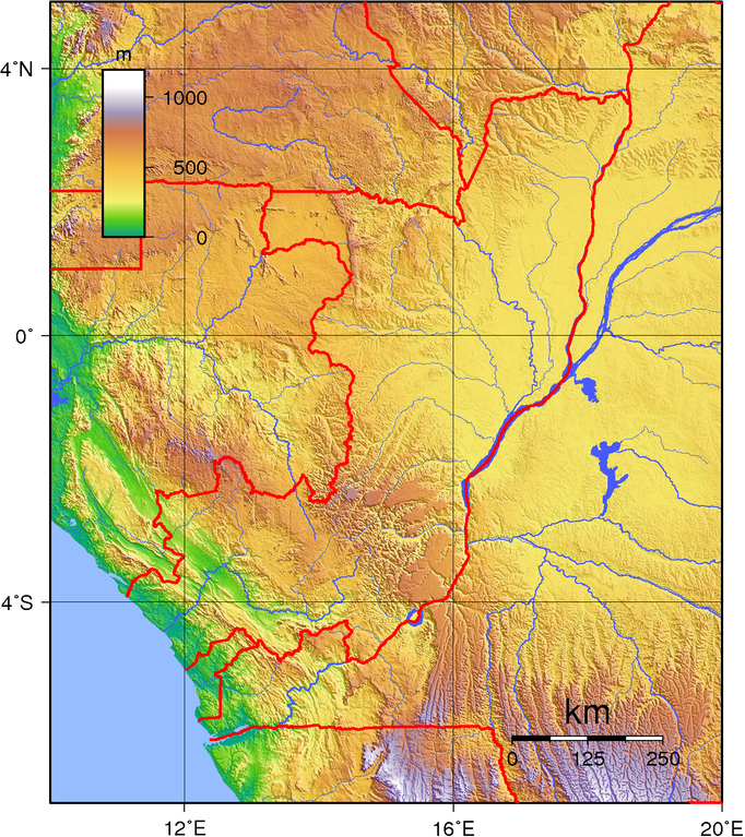
| 描述 | Topographic map of the Republic of the Congo (Brazzaville). Created with GMT from public domain SRTM data. |
| 日期 | |
| 來源 | 自己的作品 |
| 作者 | Sadalmelik |
授權條款
| 此作品已由其作者,I, Sadalmelik,釋出至公有領域。此授權條款在全世界均適用。 這可能在某些國家不合法,如果是的話: I, Sadalmelik授予任何人有權利使用此作品於任何用途,除受法律約束外,不受任何限制。 |
檔案歷史
點選日期/時間以檢視該時間的檔案版本。
| 日期/時間 | 縮圖 | 尺寸 | 使用者 | 備註 | |
|---|---|---|---|---|---|
| 目前 | 2007年6月29日 (五) 19:28 | | 1,334 × 1,501(3.52 MB) | Sadalmelik | {{Information |Description=Topographic map of the Republic of the Congo (Brazzaville). Created wth GMT from public domain SRTM data. |Source=self-made |Date=June 29, 2007 |Author= Sadalmelik }} [[Category:Maps of the Republic of the C |
檔案用途
下列頁面有用到此檔案:
全域檔案使用狀況
以下其他 wiki 使用了這個檔案:
- af.wikipedia.org 的使用狀況
- da.wikipedia.org 的使用狀況
- en.wikipedia.org 的使用狀況
- es.wikipedia.org 的使用狀況
- fa.wikipedia.org 的使用狀況
- hu.wikipedia.org 的使用狀況
- ja.wikipedia.org 的使用狀況
- ka.wikipedia.org 的使用狀況
- lt.wikipedia.org 的使用狀況
- mdf.wikipedia.org 的使用狀況
- no.wikipedia.org 的使用狀況
- uk.wikipedia.org 的使用狀況
- vep.wikipedia.org 的使用狀況