
File:2012-11-06 09-57-49-fort-du-mt-bart.jpg

預覽大小:800 × 531 像素。 其他解析度:320 × 213 像素 | 640 × 425 像素 | 1,024 × 680 像素 | 1,280 × 850 像素 | 2,560 × 1,701 像素 | 4,287 × 2,848 像素。
原始檔案 (4,287 × 2,848 像素,檔案大小:18.55 MB,MIME 類型:image/jpeg)
摘要
| 描述 |
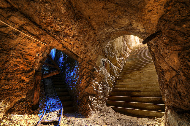
该照片用Nikon D300拍摄 Français : Fort du Mont Bart (Bavans, France): à gauche : galerie munie de sa voie de chemin de fer reliant la rue du rempart au magasin sous roc ; à droite : escalier d'accès au magasin sous roc (HDR).
English: Fort du Mont Bart (Bavans, France): in the underground gunpowder room. At left, passageway with rail tracks up to the ramparts; at right, stairs leading upwards.
Deutsch: Fort du Mont Bart (Bavans, Frankreich): Im unterirdischem Schusspulver-Raum. Links der Durchgang mit Schienen zu den Stadtmauern, rechts Treppen nach oben.
Italiano: Fort du Mont Bart, un forte parte del Sistema Séré de Rivières situato presso la città di Montbéliard, in Franca Contea, Francia.
Svenska: Fort du Mont Bart ligger i södra Montbéliard, Frankrike. |
||||||||||||||||||||||
| 日期 | |||||||||||||||||||||||
| 來源 | 自己的作品 | ||||||||||||||||||||||
| 作者 |
|
||||||||||||||||||||||

| 拍攝地點 | | 位於此地的本圖片與其他圖片: OpenStreetMap |
|---|
本檔案使用Commonist上傳。
評價
This image was selected as picture of the day on Wikimedia Commons for 4 December 2012. It was captioned as follows: English: Fort du Mont Bart (Bavans, France): At left, passageway with rail tracks up to the ramparts from the underground gunpowder room; at right, stairs leading upwards from the underground gunpowder room. Other languages:
Deutsch: Das Fort du Mont Bart in der Gemeinde Bavans im französischen Département Doubs war Teil der Barrière de fer, einer Kette von Festungsbauwerken im Osten Frankreichs. Links ein Stollen mit Bahnschienen, der das unterirdische Pulvermagazin mit der Festungsmauer verbindet, rechts die Zugangstreppe zum Pulvermagazin. English: Fort du Mont Bart (Bavans, France): At left, passageway with rail tracks up to the ramparts from the underground gunpowder room; at right, stairs leading upwards from the underground gunpowder room. Français : Fort du Mont Bart (Bavans ; France) : à gauche : galerie munie de sa voie de chemin de fer reliant la rue du rempart au magasin sous roc ; à droite : escalier d'accès au magasin sous roc. Magyar: Fort du Mont Bart, Montbéliard, Franciaország. Nederlands: Fort du Mont Bart ten zuiden van de Franse stad Montbéliard, met links de ondergrondse gang met spoorlijn naar de ondergrondse buskruitkamer, en rechts de trap die dient als toegang tot de buskruitkamer. Polski: Fort du Mont Bart, (Bavans, Francja) : Na lewo, korytarz z torami prowadzący z podziemnej prochowni do murów, na prawo, schody wiodące w górę. Русский: Форт дю Мон-Бар, Баван, Франция ქართული: ფორტ-დიუ-მონ-ბარი; მარცხნივ: მიწისქვეშა კორიდორი რკინიგზასთან ერთად; მარჯვნივ: საფეხურები. ბავანი, საფრანგეთი. 中文: 位于法国蒙贝利亚尔南部蒙马特城堡内部。 |
授權條款
此檔案採用創用CC 姓名標示 3.0 未在地化版本授權條款。
- 您可以自由:
- 分享 – 複製、發佈和傳播本作品
- 重新修改 – 創作演繹作品
- 惟需遵照下列條件:
- 姓名標示 – 您必須指名出正確的製作者,和提供授權條款的連結,以及表示是否有對內容上做出變更。您可以用任何合理的方式來行動,但不得以任何方式表明授權條款是對您許可或是由您所使用。
檔案歷史
點選日期/時間以檢視該時間的檔案版本。
| 日期/時間 | 縮圖 | 尺寸 | 使用者 | 備註 | |
|---|---|---|---|---|---|
| 目前 | 2012年11月6日 (二) 16:09 | | 4,287 × 2,848(18.55 MB) | ComputerHotline |
檔案用途
下列7個頁面有用到此檔案:
全域檔案使用狀況
以下其他 wiki 使用了這個檔案:
- be-tarask.wikipedia.org 的使用狀況
- bn.wikipedia.org 的使用狀況
- crh.wikipedia.org 的使用狀況
- cv.wikipedia.org 的使用狀況
- de.wikipedia.org 的使用狀況
- fr.wikipedia.org 的使用狀況
- hu.wikipedia.org 的使用狀況
- ka.wikipedia.org 的使用狀況
- kk.wikipedia.org 的使用狀況
- ko.wikipedia.org 的使用狀況
- krc.wikipedia.org 的使用狀況
- lbe.wikipedia.org 的使用狀況
- os.wikipedia.org 的使用狀況
- pt.wikipedia.org 的使用狀況
- ru.wikipedia.org 的使用狀況
- ru.wikinews.org 的使用狀況
- sah.wikipedia.org 的使用狀況
- sr.wikipedia.org 的使用狀況
- uk.wikipedia.org 的使用狀況
- xal.wikipedia.org 的使用狀況