
File:Unrest at Turrialba Volcano, Costa Rica.jpg

本预览的尺寸:800 × 550像素。 其他分辨率:320 × 220像素 | 640 × 440像素 | 1,024 × 704像素 | 1,280 × 880像素 | 2,560 × 1,761像素 | 3,219 × 2,214像素。
原始文件 (3,219 × 2,214像素,文件大小:4.63 MB,MIME类型:image/jpeg)
摘要
| 描述 |
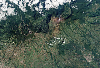
English: Turrialba Volcano, located in central Costa Rica, emits a translucent plume of volcanic gases in this natural-colour satellite image. The barren summit region of the 3,340-meter high Turrialba appears grey and brown, while the volcanic plume is a hazy blue. Fields and pastures are light green, in contrast to dark green forest that covers the high-elevation ridges. Since 2007, frequent acid rain showers caused by activity at the volcano killed or damaged much of the vegetation to the south-west of the summit, leaving the area brown and orange. |
| 日期 | |
| 来源 | NASA Earth Observatory |
| 作者 | Robert Simmon |
This image was acquired by the Advanced Land Imager (ALI) aboard NASA’s Earth Observing-1 (EO-1) satellite. ALI data provided by the NASA EO-1 team.
许可协议
| 本文件完全由NASA创作,在美国属于公有领域。根据NASA的版权方针,NASA的材料除非另有声明否则不受版权保护。(参见Template:PD-USGov/zh、NASA版权方针页面或JPL图片使用方针。) | ||
 |
警告:
|
| 注解 | 该图片含有注解:在维基媒体共享资源上查看注解 |
文件历史
点击某个日期/时间查看对应时刻的文件。
| 日期/时间 | 缩略图 | 大小 | 用户 | 备注 | |
|---|---|---|---|---|---|
| 当前 | 2010年1月28日 (四) 14:53 | | 3,219 × 2,214(4.63 MB) | Originalwana | {{Information |Description={{en|1=Turrialba Volcano, located in central Costa Rica, emits a translucent plume of volcanic gases in this natural-colour satellite image. The barren summit region of the 3,340-meter high Turrialba appears grey and brown, |
文件用途
以下页面使用本文件:
全域文件用途
以下其他wiki使用此文件:
- en.wikipedia.org上的用途
- es.wikipedia.org上的用途
- et.wikipedia.org上的用途
- it.wikipedia.org上的用途
- pl.wikipedia.org上的用途