
File:Water Detected at High Latitudes on the Moon.jpg
本预览的尺寸:600 × 600像素。 其他分辨率:240 × 240像素 | 480 × 480像素 | 768 × 768像素 | 1,024 × 1,024像素 | 1,950 × 1,950像素。
原始文件 (1,950 × 1,950像素,文件大小:536 KB,MIME类型:image/jpeg)
摘要
| 描述 |
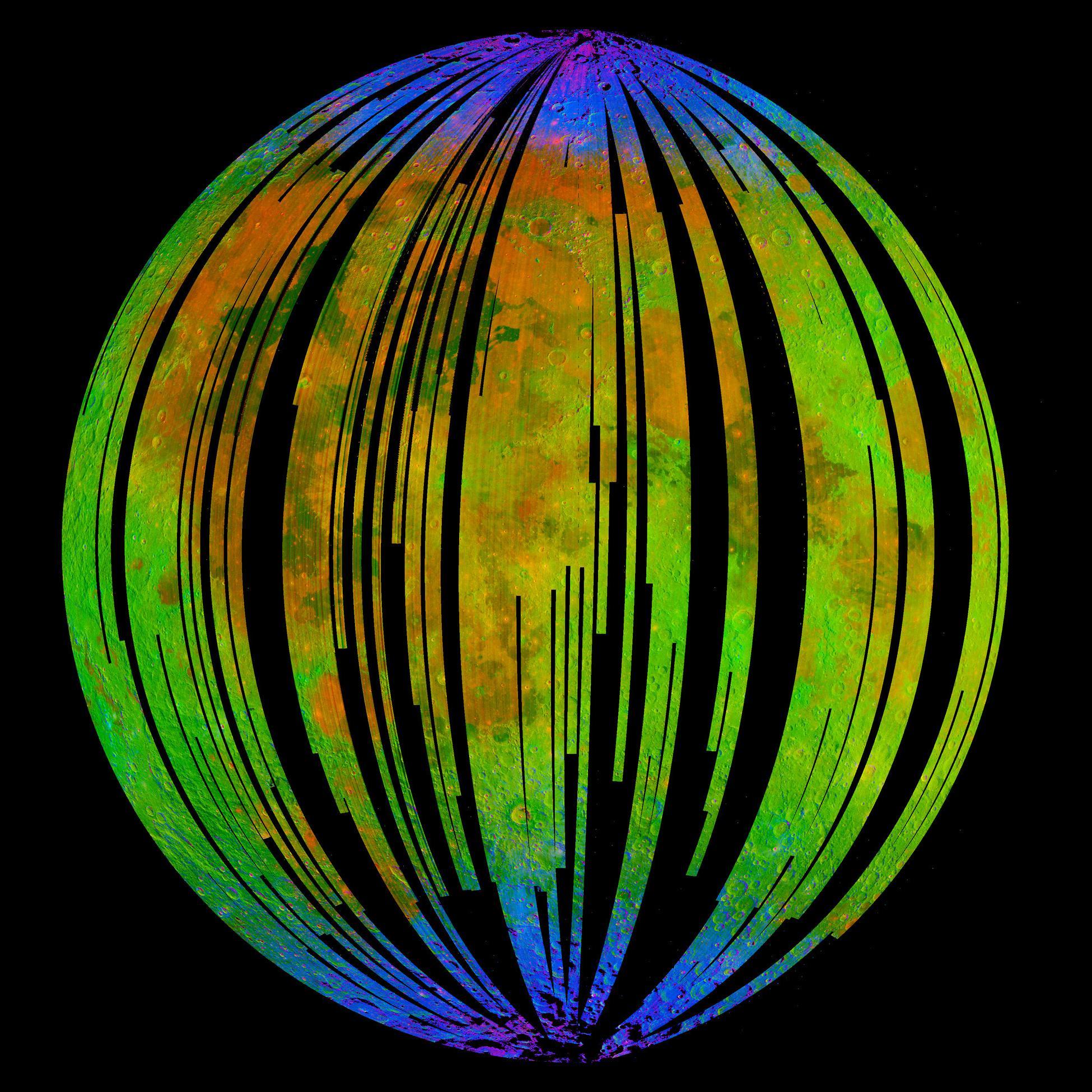
English: NASA's Moon Mineralogy Mapper, an instrument on the Indian Space Research Organization's Chandrayaan-1 mission, took this image of Earth's moon. It is a three-colour composite of reflected near-infra-red radiation from the sun, and illustrates the extent to which different materials are mapped across the side of the moon that faces Earth. Small amounts of water were detected on the surface of the moon at various locations. This image illustrates their distribution at high latitudes toward the poles. Blue shows the signature of water, green shows the brightness of the surface as measured by reflected infra-red radiation from the sun and red shows a mineral called pyroxene. |
| 日期 | |
| 来源 | NASA Image of the Day |
| 作者 | ISRO/NASA/JPL-Caltech/Brown Univ./USGS |
许可协议
| 本文件完全由NASA创作,在美国属于公有领域。根据NASA的版权方针,NASA的材料除非另有声明否则不受版权保护。(参见Template:PD-USGov/zh、NASA版权方针页面或JPL图片使用方针。) | ||
 |
警告:
|
文件历史
点击某个日期/时间查看对应时刻的文件。
| 日期/时间 | 缩略图 | 大小 | 用户 | 备注 | |
|---|---|---|---|---|---|
| 当前 | 2009年9月25日 (五) 19:52 | | 1,950 × 1,950(536 KB) | Originalwana | {{Information |Description={{en|1=NASA's Moon Mineralogy Mapper, an instrument on the Indian Space Research Organization's Chandrayaan-1 mission, took this image of [[Earth] |
文件用途
以下页面使用本文件:
全域文件用途
以下其他wiki使用此文件:
- beta.wikiversity.org上的用途
- en.wikipedia.org上的用途
- en.wikiversity.org上的用途
- es.wikipedia.org上的用途
- fr.wikipedia.org上的用途
- gl.wikipedia.org上的用途
- hu.wikipedia.org上的用途
- id.wikipedia.org上的用途
- it.wikipedia.org上的用途
- ja.wikipedia.org上的用途
- mr.wikipedia.org上的用途
- pnb.wikipedia.org上的用途
- ro.wikipedia.org上的用途
- ru.wikipedia.org上的用途
- tr.wikipedia.org上的用途
- uk.wikipedia.org上的用途
- ur.wikipedia.org上的用途