
File:Volcanoes near Usulután, El Salvador.jpg

本预览的尺寸:687 × 600像素。 其他分辨率:275 × 240像素 | 550 × 480像素 | 880 × 768像素 | 1,173 × 1,024像素 | 2,346 × 2,048像素 | 4,037 × 3,525像素。
原始文件 (4,037 × 3,525像素,文件大小:6.59 MB,MIME类型:image/jpeg)
摘要
| 描述 |
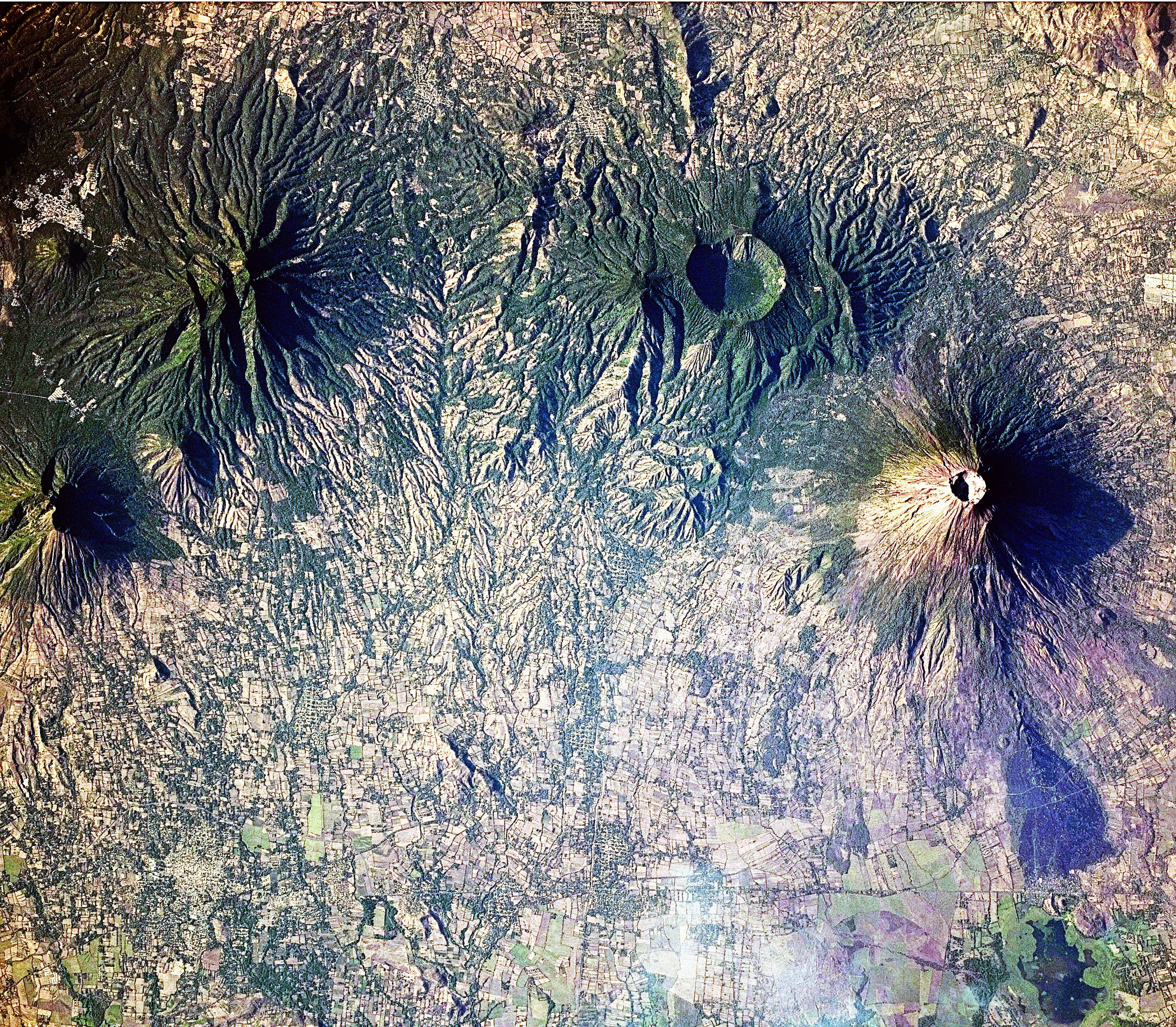
English: This astronaut photograph includes four stratovolcanoes—a type of volcano common in active subduction zones—in El Salvador, near the midpoint of the Central American Volcanic Arc. While all of the volcanoes shown here have been active during the Holocene Epoch (from about 10,000 years ago to the present), only the 2,130-meter high San Miguel (also known as Chaparrastique) has been active during historical times. The most recent activity of San Miguel was a minor gas and ash emission in 2013. The stratovolcano’s steep cone shape and well-developed summit crater are evident, along with dark lava flows. Immediately to the north-west, the truncated summit of Chinameca Volcano (also known as El Pacayal) is marked by a two-kilometre wide caldera. The caldera formed when a powerful eruption emptied the volcano’s magma chamber, causing the chamber’s roof to collapse. Like its neighbour San Miguel, Chinameca’s slopes host coffee plantations. Moving to the west, the eroded cone of El Tigre Volcano is visible. El Tigre formed during the Pleistocene Epoch (1.8 million to about 10,000 years ago), and it is likely the oldest of the stratovolcanoes in the image. Usulután Volcano is directly south-west of El Tigre. While the flanks of Usulután have been dissected by streams, the mountain still retains a summit crater that is breached on the eastern side. Several urban areas—recognizable as light grey to white regions contrasting with green vegetation and tan fallow agricultural fields—are located in the vicinity of these volcanoes, including the town of Usulután (lower left) and Santiago de María (upper left). |
| 日期 | |
| 来源 | NASA Earth Observatory |
| 作者 | NASA Expedition 23 crew |
| 相机位置 | | 在以下服务上查看本图像和附近其他图像: OpenStreetMap |
|---|
本图像或视频收录于美国国家航空航天局 (NASA)休斯顿太空中心(Johnson Space Center),其照片编号是: ISS023-E-22411 此标签不表示文件的著作权状态。任何文件在附有此标签的同時还需要一个有效的著作权标签。请参阅许可协议说明页面以了解更多信息。 其他语言:
|
Image acquired with a Nikon D3X digital camera fitted with an effective 340 mm lens, and is provided by the ISS Crew Earth Observations experiment and Image Science & Analysis Laboratory, Johnson Space Center.
许可协议
| 本文件完全由NASA创作,在美国属于公有领域。根据NASA的版权方针,NASA的材料除非另有声明否则不受版权保护。(参见Template:PD-USGov/zh、NASA版权方针页面或JPL图片使用方针。) | ||
 |
警告:
|
| 註解 | 該圖片含有註解:在維基媒體共享資源上查看註解 |
文件历史
点击某个日期/时间查看对应时刻的文件。
| 日期/时间 | 缩略图 | 大小 | 用户 | 备注 | |
|---|---|---|---|---|---|
| 当前 | 2010年4月26日 (一) 11:10 | | 4,037 × 3,525(6.59 MB) | Originalwana | {{Information |Description={{en|1=This astronaut photograph includes four stratovolcanoes—a type of volcano common in active subduction zones—in El Salvador, near the midpoint of the Central American Volcanic Arc. While all o |
文件用途
以下页面使用本文件:
全域文件用途
以下其他wiki使用此文件:
- en.wikipedia.org上的用途
- et.wikipedia.org上的用途
- incubator.wikimedia.org上的用途
- Wn/ppl/Achtu Iswat
- Wn/ppl/Ashan 33 shiwit kimiktijket Monseñor Romero
- User:A R King/NavPanel
- Template:Wn/ppl/NavPanel
- Template:Wn/ppl/OtherNews
- Wn/ppl/Chujchuntal
- Wn/ppl/Ajamat
- Wn/ppl/Tikmati
- Wn/ppl/Tajkwilultal
- Wn/ppl/Ken ijtuk tik Kuskatan
- Wn/ppl/Ken ijtuk iwan takamet wan siwatket
- Wn/ppl/Takat wan pelu kinpalewiat siwapipil pal te atukit
- Wn/ppl/Ken ijtuk tik Canada
- Wn/ppl/Pashaluani
- Wn/ppl/Ken ijtuk iwan tamatilis
- Wn/ppl/Ken ijtuk iwan culturaj
- Wn/ppl/Ken ijtuk iwan ne Nawataketzalis
- Wn/ppl/Ken ijtuk iwan tayektzinchiwalis
- Wn/ppl/Ken ijtuk tik Meshijku
- Wn/ppl/Ken ijtuk tik ESA
- Wn/ppl/Ken ijtuk tik Shiktal
- Wn/ppl/Ken ijtuk tik Tatzinu America
- Wn/ppl/Ken ijtuk tik Ewropa
- Wn/ppl/Ken ijtuk tik AAO
- Wn/ppl/Kujkutu
- Wn/ppl/Techajkawtuk ne 'Tepusnantzin' Margaret Thatcher
- Wn/ppl/Ken ijtuk tik Caribe
- Wn/ppl/Ajawilti
- Wn/ppl/Kwak ne tepet pukkisa, ne weyat shuchikisa
- Wn/ppl/Takwikalistal
- Wn/ppl/AllAgenda
- Wn/ppl/Teishpejpenalis Venezuela 2013
- Wn/ppl/SIDA tik Africa: tupajpakilis ipanpa Malik
- Template:Wn/ppl/Dummy2
- Template:Wn/ppl/Dummy2Backup
- Wn/ppl/Kimiktiat se takapiltzin siwayulu pal kishkwepat takat
- Wn/ppl/Tejemet nusan tikpiat se tutaketzalis
- Wn/ppl/Tikwakan ijinsectoj
- Wn/ppl/Mumulutza Chaparrastike
- Wn/ppl/Mikik ne Chickasawtaketza Emily Johnson Dickerson
- Wp/na/Usulutan
- it.wikipedia.org上的用途
- mk.wikipedia.org上的用途
- nl.wikipedia.org上的用途