
File:Venusvulkan Tick-Typ.jpg

原始文件 (1,637 × 1,433像素,文件大小:770 KB,MIME类型:image/jpeg)
| 描述 |
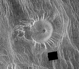
This Magellan image is of an area located in the Eistla Region [Error: This is in the Alpha Regio[1]] of Venus in the southern hemisphere and is centered at 5.5 degrees east longitude, 18 degrees south latitude. It is 122 kilometers (76 miles) across east to west and 107 kilometers (66 miles) north to south. North is at the top of the image. Shown is an unusual volcanic edifice unlike all others previously observed. It is approximately 66 kilometers (41 miles) across at the base and has a relatively flat, slightly concave summit 35 kilometers (22 miles) in diameter. The sides of the edifice are characterized by radiating ridges and valleys that impart a fluted appearance. To the west, the rim of the structure appears to have been breached by dark lava flows that emanated from a shallow summit pit approximately 5 kilometers (3 miles) in diameter and traveled west along a channel approximately 5 kilometers wide and 27 kilometers (17 miles) long. A series of coalescing, collapsed pits 2 to 10 kilometers (1.2 to 6.2 miles) in diameter are located 10 kilometers (6 miles) west of the summit. The edifice and western pits are circumscribed by faint, concentric lineaments up to 70 kilometers (43 miles) in diameter. A series of north northwest trending graben are deflected eastward around the edifice; the interplay of these graben and the fluted rim of the edifice produce a distinctive scalloped pattern in the image. Several north northwest trending lineaments cut directly across the summit region. This peculiar volcanic construct is located 25 to 30 kilometers (15 to 19 miles) north of Alpha Regio, a highly deformed region of tessera terrain. A collection of at least six similar volcanoes has been observed near Thetis Regio, a region of tessera within Aphrodite Terra. Thus, these unusual constructs tentatively appear to be spatially associated with regions of tessera. A tessera is a complex, deformed terrain on Venus consisting of at least two sets of intersecting ridges and troughs. The implications of this spatial association on the unusual morphology of these constructs are being investigated. The feature is unnamed as for 2016 (a map of the region) |
| 日期 | image published 29. Jan. 1996 |
| 来源 |
NASA planetary photojournal |
| 作者 | NASA/JPL |
| 授权 (二次使用本文件) |
Copyright information from http://www.jpl.nasa.gov/images/policy/index.cfm - Unless otherwise noted, images and video on JPL public web sites (public sites ending with a jpl.nasa.gov address) may be used for any purpose without prior permission [...] |
| 此标签不表示文件的著作权状态。任何文件在附有此标签的同時还需要一个有效的著作权标签。请参阅许可协议说明页面以了解更多信息。 其他语言:
|
| 本文件完全由NASA创作,在美国属于公有领域。根据NASA的版权方针,NASA的材料除非另有声明否则不受版权保护。(参见Template:PD-USGov/zh、NASA版权方针页面或JPL图片使用方针。) | ||
 |
警告:
|
文件历史
点击某个日期/时间查看对应时刻的文件。
| 日期/时间 | 缩略图 | 大小 | 用户 | 备注 | |
|---|---|---|---|---|---|
| 当前 | 2006年2月12日 (日) 22:19 | | 1,637 × 1,433(770 KB) | Arnomane | higher resolution |
| 2005年9月2日 (五) 17:01 |  | 1,068 × 935(285 KB) | Lotse | *'''Original Caption Released with Image:''' This Magellan image is of an area located in the Eistla Region of Venus in the southern hemisphere and is centered at 5.5 degrees east longitude, 18 degrees south latitude. It is 122 kilometers (76 miles) acros |
文件用途
全域文件用途
以下其他wiki使用此文件:
- ar.wikipedia.org上的用途
- de.wikipedia.org上的用途
- en.wikipedia.org上的用途
- eu.wikipedia.org上的用途
- he.wikipedia.org上的用途
- hu.wikipedia.org上的用途
- id.wikipedia.org上的用途
- nl.wikipedia.org上的用途
- ro.wikipedia.org上的用途
- ru.wikipedia.org上的用途
- sr.wikipedia.org上的用途
- uk.wikipedia.org上的用途