
File:Venus dome 3D.jpg

本预览的尺寸:750 × 600像素。 其他分辨率:300 × 240像素 | 600 × 480像素 | 960 × 768像素 | 1,280 × 1,024像素 | 2,560 × 2,048像素 | 5,000 × 4,000像素。
原始文件 (5,000 × 4,000像素,文件大小:1.17 MB,MIME类型:image/jpeg)
摘要
| 描述 |
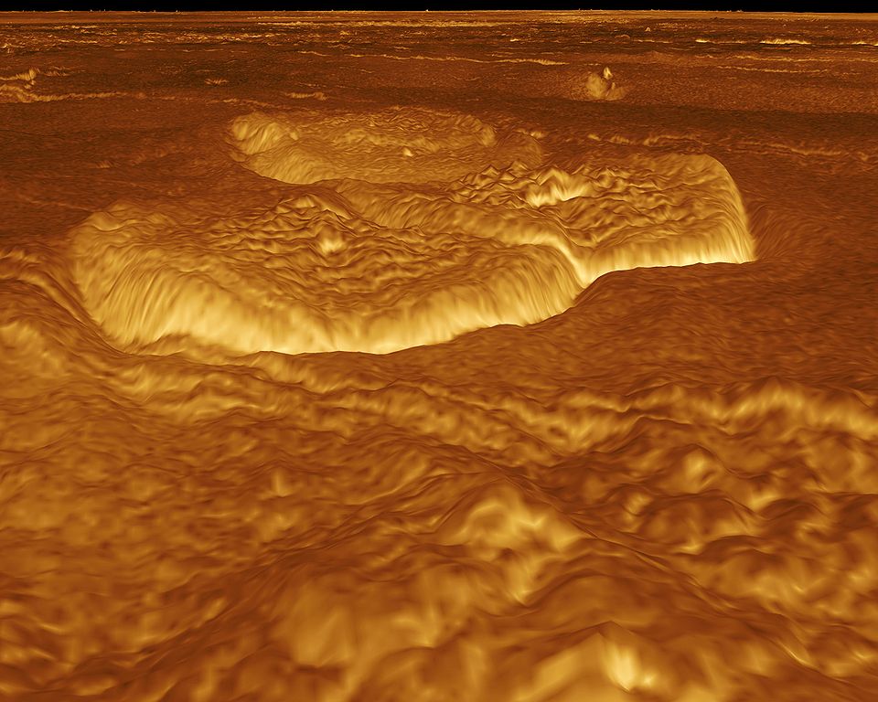
English: A portion of the eastern edge of Alpha Regio is displayed in this three-dimensional perspective view of the surface of Venus. The viewpoint is located at approximately 30 degrees south latitude, 11.8 degrees east longitude at an elevation of 2.4 kilometers (3.8 miles). The view is to the northeast at the center of an area containing seven circular dome-like hills. The average diameter of the hills is 25 kilometers (15 miles) with maximum heights of 750 meters (2,475 feet). Three of the hills are visible in the center of the image. Fractures on the surrounding plains are both older and younger than the domes. The hills may be the result of viscous or thick eruptions of lava coming from a vent on the relatively level ground, allowing the lava to flow in an even lateral pattern. The concentric and radial fracture patterns on their surfaces suggests that a chilled outer layer formed, then further intrusion in the interior stretched the surface. An alternative interpretation is that domes are the result of shallow intrusions of molten lava, causing the surface to rise. If they are intrusive, then magma withdrawal near the end of the eruptions produced the fractures. The bright margins possibly indicate the presence of rock debris or talus at the slopes of the domes. Resolution of the Magellan data is about 120 meters (400 feet). Magellan's synthetic aperture radar is combined with radar altimetry to develop a three-dimensional map of the surface. A perspective view is then generated from the map. Simulated color and a process called radar-clinometry are used to enhance small-scale structures. The simulated hues are based on color images recorded by the Soviet Venera 13 and 14 spacecraft. The image was produced by the JPL Multimission Image Processing Laboratory by Eric De Jong, Jeff Hall, Myche McAuley, and Randy Kirk of the United States Geological Survey, and is a single frame from the movie released at the May 29, 1991 Magellan news conference.
Čeština: Útvary na planetě Venuši, východně od Alpha Regio. Obraz byl vytvořen v laboratoři JPL Multimission Image Processing Laboratory, autory jsou Eric De Jong, Jeff Hall, Myche McAuley a Randy Kirk. Obraz byl získán metodou radarové klinometrie (měření sklonu) a je vyobrazen v nepravých barvách. |
| 日期 | |
| 来源 | http://photojournal.jpl.nasa.gov/catalog/PIA00246 |
| 作者 | NASA, JPL Multimission Image Processing Laboratory, U.S Geological Survey |
| 授权 (二次使用本文件) |
http://nssdc.gsfc.nasa.gov/photo_gallery/photogallery-faq.html#use |
| 此标签不表示文件的著作权状态。任何文件在附有此标签的同時还需要一个有效的著作权标签。请参阅许可协议说明页面以了解更多信息。 其他语言:
|
许可协议
| 本文件完全由NASA创作,在美国属于公有领域。根据NASA的版权方针,NASA的材料除非另有声明否则不受版权保护。(参见Template:PD-USGov/zh、NASA版权方针页面或JPL图片使用方针。) | ||
 |
警告:
|
文件历史
点击某个日期/时间查看对应时刻的文件。
| 日期/时间 | 缩略图 | 大小 | 用户 | 备注 | |
|---|---|---|---|---|---|
| 当前 | 2005年9月1日 (四) 21:13 | | 5,000 × 4,000(1.17 MB) | Bricktop | larger |
| 2005年9月1日 (四) 20:30 |  | 645 × 516(45 KB) | Lotse | *'''Original Caption Released with Image:''' A portion of the eastern edge of Alpha Regio is displayed in this three-dimensional perspective view of the surface of Venus. The viewpoint is located at approximately 30 degrees south latitude, 11.8 degrees e |
文件用途
以下页面使用本文件:
全域文件用途
以下其他wiki使用此文件:
- ar.wikipedia.org上的用途
- ca.wikipedia.org上的用途
- cs.wikipedia.org上的用途
- de.wikipedia.org上的用途
- en.wikipedia.org上的用途
- en.wikiversity.org上的用途
- fr.wikipedia.org上的用途
- hy.wikipedia.org上的用途
- ja.wikipedia.org上的用途
- mk.wikipedia.org上的用途
- nl.wikipedia.org上的用途
- pl.wiktionary.org上的用途
- ru.wikipedia.org上的用途
- uk.wikipedia.org上的用途