
File:South Luconia Shoals f 12.jpg

本预览的尺寸:800 × 453像素。 其他分辨率:320 × 181像素 | 640 × 362像素 | 1,000 × 566像素。
原始文件 (1,000 × 566像素,文件大小:187 KB,MIME类型:image/jpeg)
摘要
| 描述 |
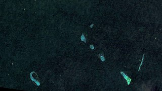
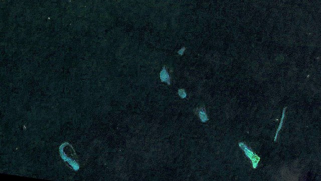
Deutsch: Landsat 7 Satellitenbild der südlichen Luconia-Untiefen (auch -Riffe, englisch South Luconia Shoals) im Südchinesische Meer südwestlich der Spratly-Inseln auf dem Festlandsockel vor dem malaysischen Bundesstaat Sarawak. Die Belichtung des Bilds wurde um ca. 12 Blendenstufen angehoben. Die Originalfarbe (RGB: 52,29,61) spielt ins Violette, daher wurde eine Farbüberlagerung (RGB:6,36,47) verwendet auf Basis der Farbe des Satelliten-Bilds von Bing Maps für diese Koordinaten 5°36′0.0″N 112°36′0.0″W / 5.6°N 112.6°W. English: Landsat 7 satellite image of the South Luconia Shoals in the South China Sea southwest of the Spratly Islands on the continental shelf in front of the Malaysian state of Sarawak. The exposure of the image has been increased by about 12 f-stops. The original color (RGB: 52,29,61) is purplish, therefore a color overlay was used which is based on the color (RGB:6,36,47) of the Satellite Image of Bing Maps for this coordinates 5°36′0.0″N 112°36′0.0″W / 5.6°N 112.6°W. |
| 日期 | |
| 来源 | https://web.archive.org/web/20120724041608/http://www.oceandots.com/pacific/luconia/ |
| 作者 | NASA |
许可协议
| 本文件完全由NASA创作,在美国属于公有领域。根据NASA的版权方针,NASA的材料除非另有声明否则不受版权保护。(参见Template:PD-USGov/zh、NASA版权方针页面或JPL图片使用方针。) | ||
 |
警告:
|
| 註解 | 該圖片含有註解:在維基媒體共享資源上查看註解 |
文件历史
点击某个日期/时间查看对应时刻的文件。
| 日期/时间 | 缩略图 | 大小 | 用户 | 备注 | |
|---|---|---|---|---|---|
| 当前 | 2015年5月18日 (一) 17:09 | | 1,000 × 566(187 KB) | MagentaGreen | =={{int:filedesc}}== {{Information |description={{de|1=Landsat 7 Satellitenbild der südlichen Luconia-Untiefen (auch -Riffe, englisch South Luconia Shoals) im Südchinesische Meer südwestlich der Spratly-Inseln auf dem Festlandsockel vor dem malaysis... |
文件用途
以下页面使用本文件:
全域文件用途
以下其他wiki使用此文件:
- de.wikipedia.org上的用途
- en.wikipedia.org上的用途
- ja.wikipedia.org上的用途
- ms.wikipedia.org上的用途