
File:Relief Map of Germany, Black Forest.png

本预览的尺寸:506 × 600像素。 其他分辨率:202 × 240像素 | 405 × 480像素 | 1,000 × 1,185像素。
原始文件 (1,000 × 1,185像素,文件大小:1.48 MB,MIME类型:image/png)
摘要
| 描述 |
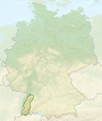
English: Relief map of Germany with outlines of the Black Forest. Equirectangular projection, N/S stretching 150 %. Geographic limits of the map: * N: 55.1° N * S: 47.2° N * W: 5.5° E * E: 15.5° E
Deutsch: Deutschlandkarte mit Umrissen des Schwarzwalds gemäß Naturräumlichen Großregionen Deutschlands nach dem System des Bundesamtes für Naturschutz (BfN). |
| 日期 | (UTC) |
| 来源 |
本檔案衍生自: |
| 作者 |
|


许可协议
本文件采用知识共享署名-相同方式共享 3.0 未本地化版本许可协议授权。
- 您可以自由地:
- 共享 – 复制、发行并传播本作品
- 修改 – 改编作品
- 惟须遵守下列条件:
- 署名 – 您必须对作品进行署名,提供授权条款的链接,并说明是否对原始内容进行了更改。您可以用任何合理的方式来署名,但不得以任何方式表明许可人认可您或您的使用。
- 相同方式共享 – 如果您再混合、转换或者基于本作品进行创作,您必须以与原先许可协议相同或相兼容的许可协议分发您贡献的作品。
原始上传日志
This image is a derivative work of the following images:
- File:Relief_Map_of_Germany.png licensed with Cc-by-sa-3.0
- 2010-08-28T17:48:23Z Виктор В 1000x1185 (1796090 Bytes) Рельеф дна
- 2010-08-28T16:40:16Z Виктор В 1000x1185 (1733013 Bytes) мелкие исправления
- 2010-08-28T12:03:54Z Виктор В 1000x1185 (1766531 Bytes) == {{int:filedesc}} == {{Information |Description={{en|Relief map of [[:en:Germany|Germany]]}} [[:en:Equirectangular projection|Equirectangular projection]], N/S stretching 150 %. Geographic limits of the map: * N: 55.1° N *
- File:Deutschland_Naturraeumliche_Grossregionen.png licensed with Cc-by-sa-3.0, GFDL
- 2011-09-29T17:01:59Z NordNordWest 1826x2318 (5659071 Bytes) upd
- 2011-09-22T18:51:25Z NordNordWest 1826x2318 (5641169 Bytes) ergänzt
- 2011-09-14T18:57:42Z NordNordWest 1826x2318 (5615307 Bytes) update
- 2008-06-12T10:16:41Z NordNordWest 1980x2322 (5911072 Bytes)
- 2008-06-12T09:03:16Z NordNordWest 1979x2322 (5753037 Bytes)
- 2008-06-11T19:04:47Z NordNordWest 1979x2321 (5766960 Bytes) == Beschreibung == {{Information |Description= {{de|Karte der [[:de:Naturräumliche Haupteinheiten Deutschlands|Naturräumlichen Haupteinheiten Deutschlands]] nach dem System des [[:de:Bundesamt für Naturschutz|Bundesamtes f
Uploaded with derivativeFX
文件历史
点击某个日期/时间查看对应时刻的文件。
| 日期/时间 | 缩略图 | 大小 | 用户 | 备注 | |
|---|---|---|---|---|---|
| 当前 | 2013年7月28日 (日) 02:40 | | 1,000 × 1,185(1.48 MB) | Sitacuisses | == {{int:filedesc}} == {{Information |Description={{en|Relief map of Germany with outlines of the Black Forest. Equirectangular projection, N/S stretching 150 %. Geographic limits ... |
文件用途
以下页面使用本文件:
全域文件用途
以下其他wiki使用此文件:
- af.wikipedia.org上的用途
- arz.wikipedia.org上的用途
- ast.wikipedia.org上的用途
- bh.wikipedia.org上的用途
- bn.wikipedia.org上的用途
- ca.wikipedia.org上的用途
- cs.wikipedia.org上的用途
- da.wikipedia.org上的用途
- de.wikipedia.org上的用途
- en.wikipedia.org上的用途
- en.wikivoyage.org上的用途
- eo.wikipedia.org上的用途
- es.wikipedia.org上的用途
- eu.wikipedia.org上的用途
- fa.wikipedia.org上的用途
- fi.wikipedia.org上的用途
- fr.wikipedia.org上的用途
- ga.wikipedia.org上的用途
- he.wikipedia.org上的用途
- it.wikivoyage.org上的用途
- ja.wikipedia.org上的用途
- ka.wikipedia.org上的用途
- ml.wikipedia.org上的用途
- pl.wikipedia.org上的用途
- pl.wikivoyage.org上的用途
- ro.wikipedia.org上的用途
- sco.wikipedia.org上的用途
- sk.wikipedia.org上的用途
- sl.wikipedia.org上的用途
- ta.wikipedia.org上的用途
- th.wikipedia.org上的用途
- tr.wikipedia.org上的用途
- ur.wikipedia.org上的用途
- www.wikidata.org上的用途