
File:Pakistan population density.png
本预览的尺寸:640 × 599像素。 其他分辨率:256 × 240像素 | 820 × 768像素 | 1,094 × 1,024像素 | 2,187 × 2,048像素 | 5,400 × 5,056像素。
原始文件 (5,400 × 5,056像素,文件大小:1.88 MB,MIME类型:image/png)

|
本文件已被Population Density by Pakistani District - 2017 Census.SVG取代。建议您使用其他文件。请注意,删除被取代的图片需要达成一致。 使用其他文件的理由:“SVG File that uses a better template, is more detailed, and fixes many errors”
|
new file |
摘要
| 描述 |
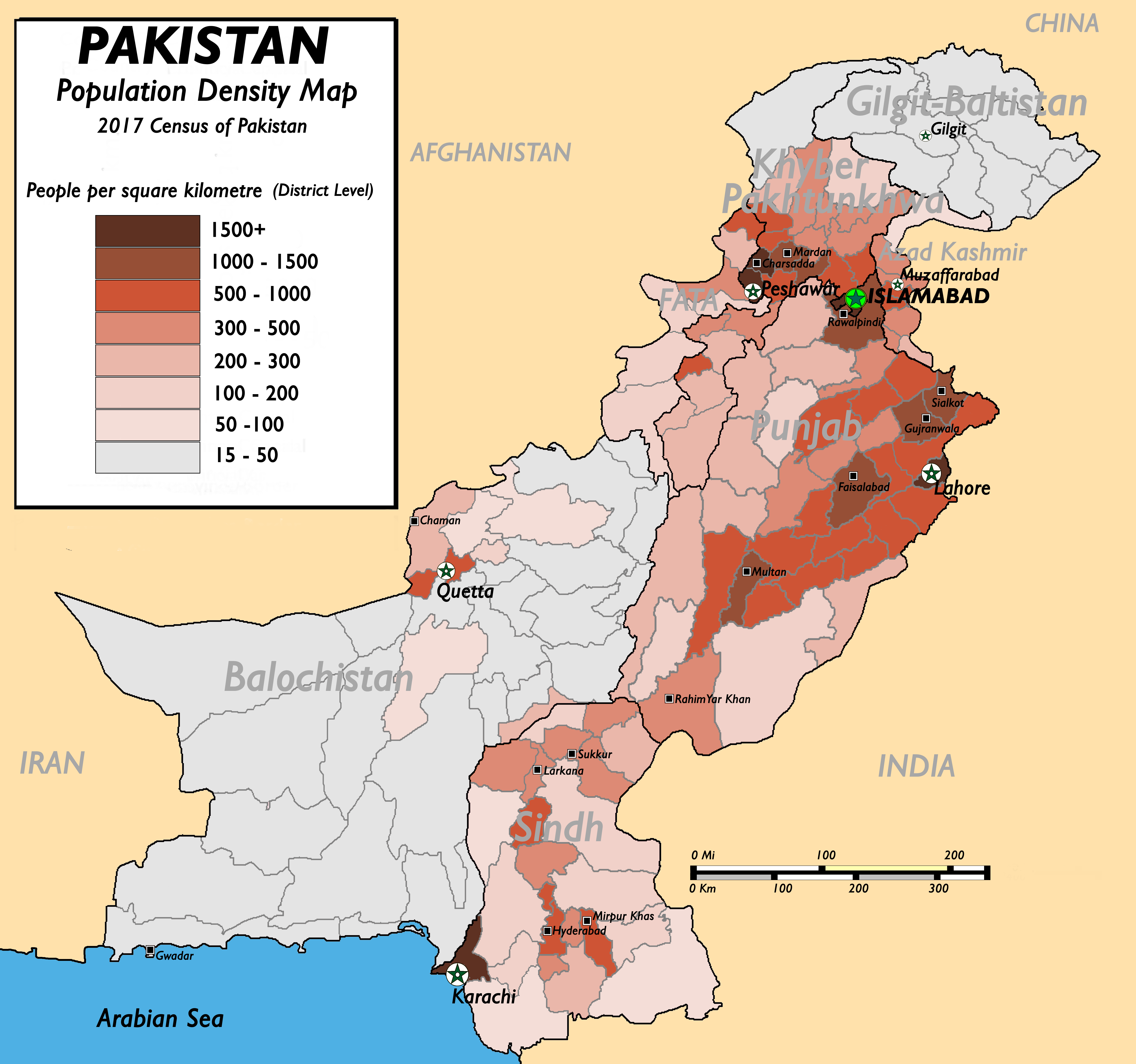
English: Pakistan Population Density Map (English). (Abbreviations used: 1. NWFP = North West Frontier Province, 2. FATA = Federally Administered Tribal Areas.) |
| 日期 | 2009年8月13日 (原始上传日期) |
| 来源 |
(New version uploaded by using data from 2017 Pakistan Population Census, Official Website (原始文本: I created this work by myself with the sources of World Trade Press and Population census organisation, Government of Pakistan.) |
| 作者 | nomi887 (talk) |
许可协议
本文件采用知识共享署名-相同方式共享 3.0 未本地化版本许可协议授权。
- 您可以自由地:
- 共享 – 复制、发行并传播本作品
- 修改 – 改编作品
- 惟须遵守下列条件:
- 署名 – 您必须对作品进行署名,提供授权条款的链接,并说明是否对原始内容进行了更改。您可以用任何合理的方式来署名,但不得以任何方式表明许可人认可您或您的使用。
- 相同方式共享 – 如果您再混合、转换或者基于本作品进行创作,您必须以与原先许可协议相同或相兼容的许可协议分发您贡献的作品。

|
已授权您依据自由软件基金会发行的无固定段落及封面封底文字(Invariant Sections, Front-Cover Texts, and Back-Cover Texts)的GNU自由文件许可协议1.2版或任意后续版本的条款,复制、传播和/或修改本文件。该协议的副本请见“GNU Free Documentation License”。 |
您可以选择您需要的许可协议。
原始上传日志
原始描述頁面位於這裡。下列使用者名稱均來自en.wikipedia。
- 2009-08-13 11:22 Brainlara73 1357×1348× (210478 bytes) Reverted to version as of 11:06, 13 August 2009
- 2009-08-13 11:07 Brainlara73 1357×1348× (210478 bytes) location corrected
- 2009-08-13 11:06 Brainlara73 1357×1348× (210478 bytes) location corrected
- 2009-08-13 09:57 Nomi887 1357×1348× (235717 bytes) More scrutinized version.
- 2009-07-07 11:18 Brainlara73 1361×1390× (195660 bytes) Added Jhelum in Punjab
- 2009-06-11 09:46 Nomi887 1361×1390× (212195 bytes) {{Information |Description = Pakistan Population Density Map (English). |Source = I created this work by myself with the sources of [http://www.bestcountryreports.com/Population_Map_Pakistan.html World Trade Press] and [http://www.statpak.gov
文件历史
点击某个日期/时间查看对应时刻的文件。
| 日期/时间 | 缩略图 | 大小 | 用户 | 备注 | |
|---|---|---|---|---|---|
| 当前 | 2018年12月17日 (一) 12:43 | | 5,400 × 5,056(1.88 MB) | Nomi887 | New version as per Pakistan Population Census of 2017 by using data from #REDIRECTCensus Data, Pakistan Bureau of Statistics |
| 2011年4月11日 (一) 07:57 |  | 1,389 × 1,383(220 KB) | Nomi887 | minor corrections in locations and density | |
| 2010年3月18日 (四) 17:35 |  | 1,357 × 1,348(206 KB) | Ranveig | {{Information |Description={{en|Pakistan Population Density Map (English). ''(Abbreviations used: 1. NWFP = North West Frontier Province, 2. FATA = Federally Administered Tribal Areas.)''}} |Source=Transferred from [http://en.wikipedia.org en.wikipedia]<b |
文件用途
以下页面使用本文件:
全域文件用途
以下其他wiki使用此文件:
- ba.wikipedia.org上的用途
- bn.wikipedia.org上的用途
- bs.wikipedia.org上的用途
- de.wikipedia.org上的用途
- diq.wikipedia.org上的用途
- en.wikipedia.org上的用途
- fr.wikipedia.org上的用途
- fr.wikinews.org上的用途
- hu.wikipedia.org上的用途
- inh.wikipedia.org上的用途
- io.wikipedia.org上的用途
- ja.wikipedia.org上的用途
- mr.wikipedia.org上的用途
- nl.wikipedia.org上的用途
- nl.wikinews.org上的用途
- nn.wikipedia.org上的用途
- no.wikipedia.org上的用途
- pnb.wikipedia.org上的用途
- pt.wikipedia.org上的用途
- ru.wikipedia.org上的用途
- th.wikipedia.org上的用途
- uk.wikipedia.org上的用途
- ur.wikipedia.org上的用途
- vi.wikipedia.org上的用途