
File:PIA19817-Mars-NiliFossae-CarbonateRichDeposit-20150902.jpg

原始文件 (801 × 1,280像素,文件大小:326 KB,MIME类型:image/jpeg)
摘要
| 描述 |
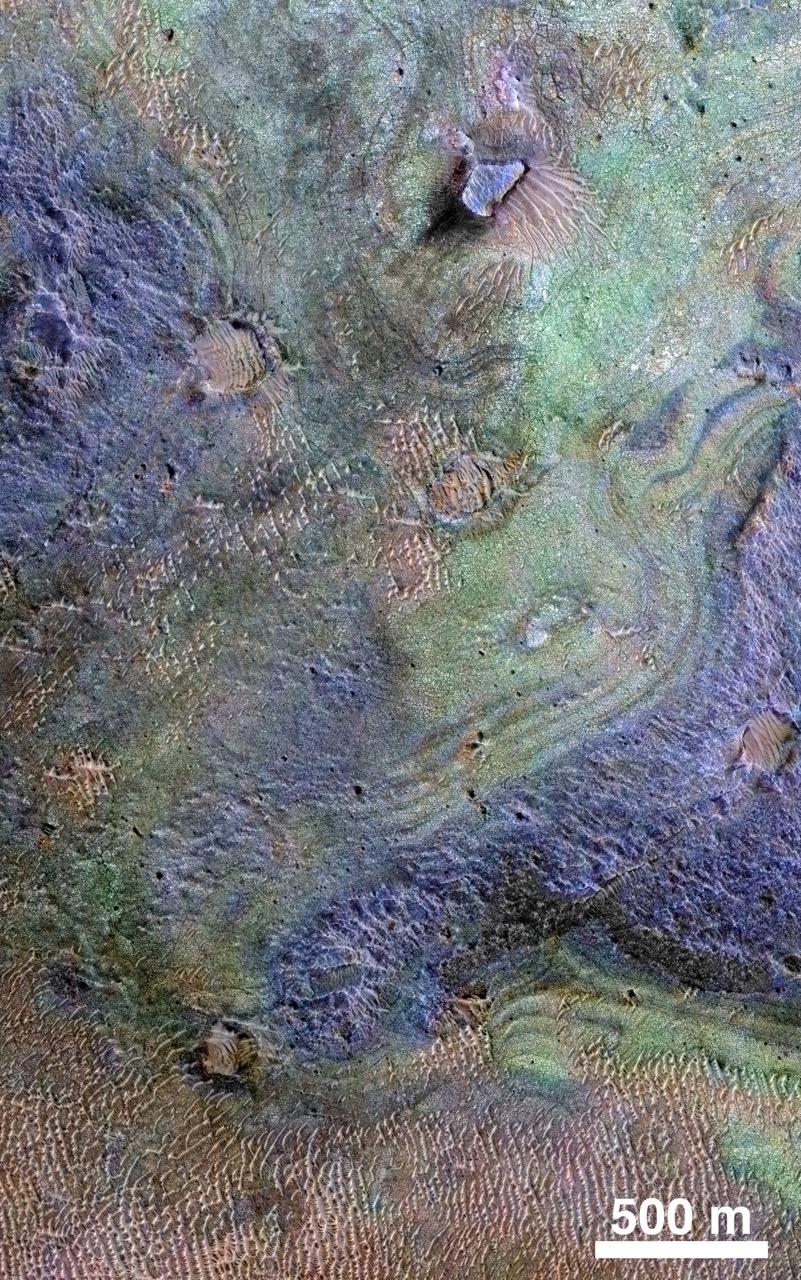
English: PIA19817: Rocks Here Sequester Some of Mars' Early Atmosphere
http://photojournal.jpl.nasa.gov/catalog/PIA19817 This view combines information from two instruments on NASA's Mars Reconnaissance Orbiter to map color-coded composition over the shape of the ground in a small portion of the Nili Fossae plains region of Mars' northern hemisphere. This site is part of the largest known carbonate-rich deposit on Mars. In the color coding used for this map, green indicates a carbonate-rich composition, brown indicates olivine-rich sands, and purple indicates basaltic composition. Carbon dioxide from the atmosphere on early Mars reacted with surface rocks to form carbonate, thinning the atmosphere by sequestering the carbon in the rocks. An analysis of the amount of carbon contained in Nili Fossae plains estimated the total at no more than twice the amount of carbon in the modern atmosphere of Mars, which is mostly carbon dioxide. That is much more than in all other known carbonate on Mars, but far short of enough to explain how Mars could have had a thick enough atmosphere to keep surface water from freezing during a period when rivers were cutting extensive valley networks on the Red Planet. Other possible explanations for the change from an era with rivers to dry modern Mars are being investigated. This image covers an area approximately 1.4 miles (2.3 kilometers) wide. A scale bar indicates 500 meters (1,640 feet). The full extent of the carbonate-containing deposit in the region is at least as large as Delaware and perhaps as large as Arizona. The color coding is from data acquired by the Compact Reconnaissance Imaging Spectrometer for Mars (CRISM), in observation FRT0000C968 made on Sept. 19, 2008. The base map showing land shapes is from the High Resolution Imaging Science Experiment (HiRISE) camera. It is one product from HiRISE observation ESP_010351_2020, made July 20, 2013. Other products from that observation are online at http://www.uahirise.org/ESP_032728_2020. The Mars Reconnaissance Orbiter has been using CRISM, HiRISE and four other instruments to investigate Mars since 2006. The Johns Hopkins University Applied Physics Laboratory, Laurel, Maryland, led the work to build the CRISM instrument and operates CRISM in coordination with an international team of researchers from universities, government and the private sector. HiRISE is operated by the University of Arizona, Tucson, and was built by Ball Aerospace & Technologies Corp., Boulder, Colorado. NASA's Jet Propulsion Laboratory, a division of the California Institute of Technology in Pasadena, manages the Mars Reconnaissance Orbiter Project for NASA's Science Mission Directorate, Washington. Lockheed Martin Space Systems, Denver, built the orbiter and collaborates with JPL to operate it. |
| 日期 | |
| 来源 | http://photojournal.jpl.nasa.gov/jpeg/PIA19817.jpg |
| 作者 | NASA/JPL-Caltech/JHUAPL/Univ. of Arizona |
许可协议
| 本文件完全由NASA创作,在美国属于公有领域。根据NASA的版权方针,NASA的材料除非另有声明否则不受版权保护。(参见Template:PD-USGov/zh、NASA版权方针页面或JPL图片使用方针。) | ||
 |
警告:
|
文件历史
点击某个日期/时间查看对应时刻的文件。
| 日期/时间 | 缩略图 | 大小 | 用户 | 备注 | |
|---|---|---|---|---|---|
| 当前 | 2015年9月3日 (四) 01:30 | | 801 × 1,280(326 KB) | Drbogdan | User created page with UploadWizard |
文件用途
以下页面使用本文件:
全域文件用途
以下其他wiki使用此文件:
- ca.wikipedia.org上的用途
- en.wikipedia.org上的用途
- es.wikipedia.org上的用途
- fr.wikipedia.org上的用途