
File:PIA17085-MarsCuriosityRover-TraverseMap-Sol351-20130801.jpg

原始文件 (3,300 × 2,550像素,文件大小:2.15 MB,MIME类型:image/jpeg)
摘要
| 描述 |
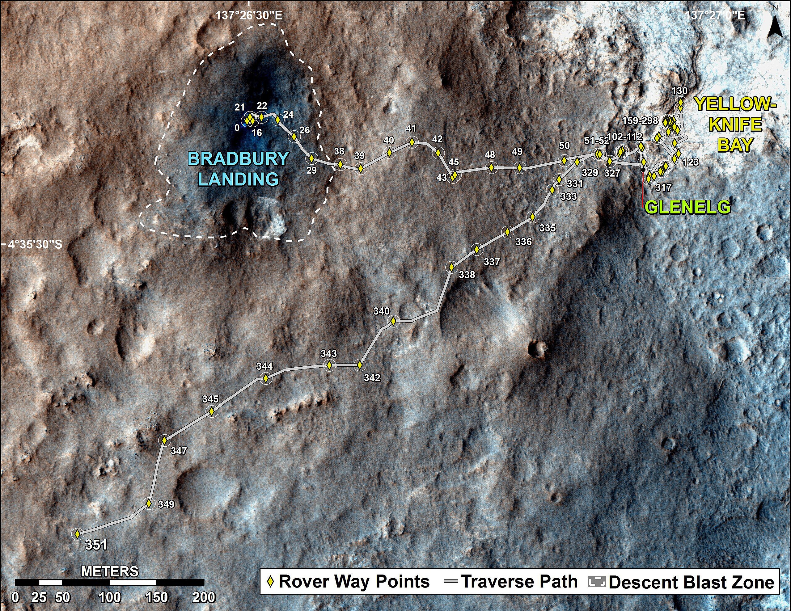
English: PIA17085: Full Curiosity Traverse Passes One-Mile Mark
http://photojournal.jpl.nasa.gov/catalog/PIA17085 NOTE: UPDATED Traverse Maps Are Here => http://mars.jpl.nasa.gov/msl/mission/whereistherovernow/ NOTE: First-Year & First-Mile Traverse Map of the Curiosity rover on Mars (August 1, 2013) (3-D). NASA Description: The total distance driven by NASA's Mars rover Curiosity passed the one-mile mark a few days before the first anniversary of the rover's landing on Mars. This map traces where Curiosity drove between landing at "Bradbury Landing" on Aug. 5, 2012, PDT, (Aug. 6, 2012 (Universal Time and EDT) and the position reached during the mission's 351st Martian day, or sol, (Aug. 1, 2013). The Sol 351 leg added 279 feet (85.1 meters) and brought the odometry since landing to about 1.05 miles (1,686 meters). The mapped area is within Gale Crater and north of the mountain called Mount Sharp in the middle of the crater. After the first use of the drill, the rover's main science destination will be on the lower reaches of Mount Sharp. For broader-context images of the area, see PIA16064 and PIA16058. The base image from the map is from the High Resolution Imaging Science Experiment Camera (HiRISE) in NASA's Mars Reconnaissance Orbiter. |
| 日期 | |
| 来源 | http://photojournal.jpl.nasa.gov/jpeg/PIA17085.jpg |
| 作者 | NASA/JPL-Caltech/Univ. of Arizona |
许可协议
| 本文件完全由NASA创作,在美国属于公有领域。根据NASA的版权方针,NASA的材料除非另有声明否则不受版权保护。(参见Template:PD-USGov/zh、NASA版权方针页面或JPL图片使用方针。) | ||
 |
警告:
|
文件历史
点击某个日期/时间查看对应时刻的文件。
| 日期/时间 | 缩略图 | 大小 | 用户 | 备注 | |
|---|---|---|---|---|---|
| 当前 | 2013年8月2日 (五) 22:17 | | 3,300 × 2,550(2.15 MB) | Drbogdan | User created page with UploadWizard |
文件用途
以下5个页面使用本文件:
全域文件用途
以下其他wiki使用此文件:
- ca.wikipedia.org上的用途
- en.wikipedia.org上的用途
- es.wikipedia.org上的用途
- fa.wikipedia.org上的用途
- fr.wikipedia.org上的用途
- it.wikipedia.org上的用途
- ja.wikipedia.org上的用途
- ko.wikipedia.org上的用途
- pl.wikipedia.org上的用途
- ru.wikipedia.org上的用途
- tr.wikipedia.org上的用途
- uk.wikipedia.org上的用途
- vi.wikipedia.org上的用途