
File:PIA13164 North Polar Cap Cross Section.jpg

本预览的尺寸:800 × 388像素。 其他分辨率:320 × 155像素 | 640 × 310像素 | 1,024 × 497像素 | 1,936 × 939像素。
原始文件 (1,936 × 939像素,文件大小:562 KB,MIME类型:image/jpeg)
摘要
| 描述 |
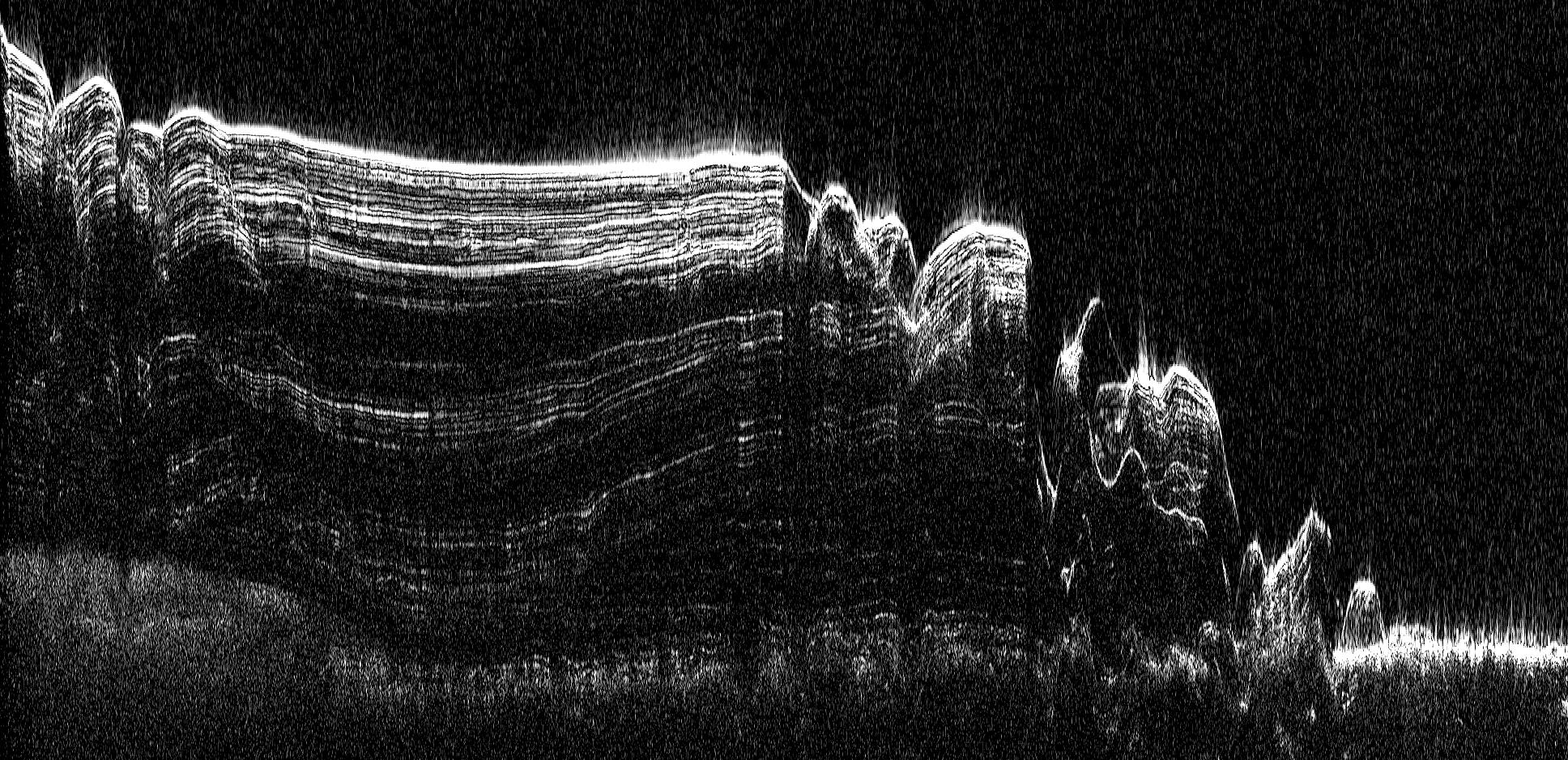
English: This image shows a cross-section of a portion of the north polar ice cap of Mars, derived from data acquired by the Mars Reconnaissance Orbiter's Shallow Radar (SHARAD), one of six instruments on the spacecraft.
The data depict the region's internal ice structure, with annotations describing different layers. The ice depicted in this graphic is approximately 2 kilometers (1.2 miles) thick and 250 kilometers (155 miles) across. White lines show reflection of the radar signal back to the spacecraft. Each line represents a place where a layer sits on top of another. Scientists study how thick the pancake-like layers are, where they bulge and how they tilt up or down to understand what the surface of the ice sheet was like in the past as each new layer was deposited. |
| 日期 | (published) |
| 来源 | Catalog page · Full-res (JPEG · TIFF) |
| 作者 | NASA/JPL-Caltech/ASI/UT |
| 其他版本 |
|


| 此标签不表示文件的著作权状态。任何文件在附有此标签的同時还需要一个有效的著作权标签。请参阅许可协议说明页面以了解更多信息。 其他语言:
|
 |
This media is a product of the Mars Reconnaissance Orbiter mission Credit and attribution belongs to the Shallow Subsurface Radar (SHARAD) team, NASA/JPL-Caltech/ASI/UT |
许可协议
| 本文件完全由NASA创作,在美国属于公有领域。根据NASA的版权方针,NASA的材料除非另有声明否则不受版权保护。(参见Template:PD-USGov/zh、NASA版权方针页面或JPL图片使用方针。) | ||
 |
警告:
|
原始上传日志
原始描述頁面位於這裡。下列使用者名稱均來自en.wikipedia。
| 日期/时间 | 大小 | 用户 | 备注 |
|---|---|---|---|
| 2010-09-20 13:18 | 1936×939× (575535 bytes) | Schaffman | {{Information |Description = Radargram of Polar Cap |Source = JPL Photojournal |Date = ~~~~~ |Author = Italian space Agency |Permission = JLP Public Use Policy |other_versions = }} |
文件历史
点击某个日期/时间查看对应时刻的文件。
| 日期/时间 | 缩略图 | 大小 | 用户 | 备注 | |
|---|---|---|---|---|---|
| 当前 | 2017年3月4日 (六) 09:23 | | 1,936 × 939(562 KB) | PhilipTerryGraham | Transferred from en.wikipedia |
文件用途
全域文件用途
以下其他wiki使用此文件:
- en.wikipedia.org上的用途