
File:Moldova-CIA WFB Map.png
本预览的尺寸:275 × 600像素。 其他分辨率:110 × 240像素 | 327 × 713像素。
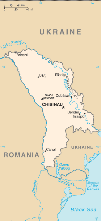
原始文件 (327 × 713像素,文件大小:14 KB,MIME类型:image/png)

文件历史
点击某个日期/时间查看对应时刻的文件。
| 日期/时间 | 缩略图 | 大小 | 用户 | 备注 | |
|---|---|---|---|---|---|
| 当前 | 2022年4月30日 (六) 14:18 | | 327 × 713(14 KB) | Claude Zygiel | Uploaded separately the enriched version following Pinkerton's advice. |
| 2022年4月15日 (五) 16:29 |  | 327 × 580(146 KB) | Claude Zygiel | Adding useful details to a current geographic map is very different from "manipulating a historical map". Please tolerate this. | |
| 2021年9月27日 (一) 04:32 |  | 327 × 713(14 KB) | GPinkerton | Reverted to version as of 09:16, 27 March 2005 (UTC) COM:CROP, manipulation of historical document | |
| 2020年7月9日 (四) 18:38 |  | 327 × 662(34 KB) | Claude Zygiel | Development and Autonomous Regions & Extreme Points (red) | |
| 2005年3月27日 (日) 09:16 |  | 327 × 713(14 KB) | Wolfman~commonswiki | {{CIA-map}} |
文件用途
全域文件用途
以下其他wiki使用此文件:
- be-tarask.wikipedia.org上的用途
- ca.wikipedia.org上的用途
- en.wikipedia.org上的用途
- en.wikisource.org上的用途
- fa.wikipedia.org上的用途
- gom.wikipedia.org上的用途
- he.wikipedia.org上的用途
- hu.wikipedia.org上的用途
- hu.wiktionary.org上的用途
- mr.wikipedia.org上的用途
- sq.wikipedia.org上的用途
- th.wikipedia.org上的用途
- tr.wikipedia.org上的用途
- udm.wikipedia.org上的用途
- vls.wikipedia.org上的用途
- www.wikidata.org上的用途
- zh-min-nan.wikipedia.org上的用途