
File:Missions in Somaliland.png

本预览的尺寸:800 × 370像素。 其他分辨率:320 × 148像素 | 640 × 296像素 | 1,357 × 628像素。
原始文件 (1,357 × 628像素,文件大小:19 KB,MIME类型:image/png)

|
File:Diplomatic missions in Somaliland.svg是此文件的矢量版本。 如果此文件质量不低于原点阵图,就应该将这个PNG格式文件替换为此文件。
File:Missions in Somaliland.png → File:Diplomatic missions in Somaliland.svg
更多信息请参阅Help:SVG/zh。 |
 |
摘要
| 描述 |
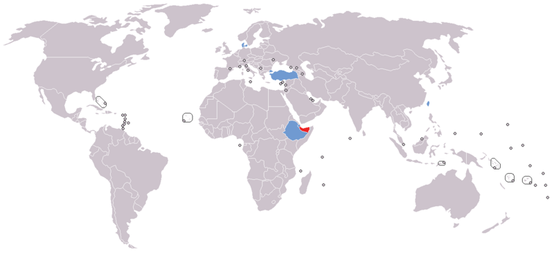
English: Map of diplomatic missions in Somaliland
Somaliland
States with embassy in Somaliland (none)
States with representative office or consulate in Somaliland
States with non-resident embassy in Somaliland (none)
Disputed region |
| 日期 | |
| 来源 |
自己的作品 本檔案衍生自: World map model.png |
| 作者 | Jan CZ |
许可协议
我,本作品著作权人,特此采用以下许可协议发表本作品:
| 本作品采用知识共享CC0 1.0 通用公有领域贡献许可协议授权。 | |
| 采用本宣告发表本作品的人,已在法律允许的范围内,通过在全世界放弃其对本作品拥有的著作权法规定的所有权利(包括所有相关权利),将本作品贡献至公有领域。您可以复制、修改、传播和表演本作品,将其用于商业目的,无需要求授权。
|
文件历史
点击某个日期/时间查看对应时刻的文件。
| 日期/时间 | 缩略图 | 大小 | 用户 | 备注 | |
|---|---|---|---|---|---|
| 当前 | 2023年11月4日 (六) 10:05 | | 1,357 × 628(19 KB) | Siirski | Reverted to version as of 15:07, 22 August 2020 (UTC) |
| 2023年10月1日 (日) 18:50 |  | 1,357 × 628(37 KB) | Caawiyahaderon | https://www.thehindu.com/news/international/pro-somalia-militia-takes-key-army-base-in-breakaway-region/article67238670.ece | |
| 2020年8月22日 (六) 15:07 |  | 1,357 × 628(19 KB) | Tom282f3 | Added Taiwan in the map. Representative offices established in both countries' capital. | |
| 2020年6月20日 (六) 17:52 |  | 1,357 × 628(26 KB) | Kzl55 | Reverted to version as of 12:11, 19 June 2020 (UTC) Irrelevant, reverted to stable version | |
| 2020年6月20日 (六) 15:07 |  | 1,357 × 628(37 KB) | Meelpringthusss | If Sool, Sanaag and Cayn residents believe Somaliland doesn't represent them, then the map shouldn't mislead people into thinking they do. Clarified at File_talk:Somalia_map_states_regions_districts.png#There_is_nuance_with_regards_to_control | |
| 2020年6月19日 (五) 12:11 |  | 1,357 × 628(26 KB) | Chipmunkdavis | Reverted to version as of 21:24, 14 April 2016 (UTC) Irrelevant to the image, adds no clarity. | |
| 2020年6月17日 (三) 11:22 |  | 1,357 × 628(37 KB) | Meelpringthusss | added disputed region | |
| 2016年4月14日 (四) 21:24 |  | 1,357 × 628(26 KB) | Jan CZ | User created page with UploadWizard |
文件用途
以下页面使用本文件:
全域文件用途
以下其他wiki使用此文件:
- en.wikibooks.org上的用途
- so.wikipedia.org上的用途