
File:Mare Boreum Map.JPG
此为最大尺寸。
Mare_Boreum_Map.JPG (479 × 478像素,文件大小:35 KB,MIME类型:image/jpeg)
摘要
| 描述 |
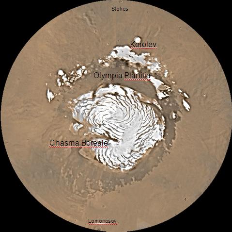
English: Map of Mare Boreum Mars quadrangle. The small, colored rectangles represent image footprints for the narrow angle camera on the Mars Global Surveyor. Some are about 1 mile wide, the otheers are about 2 miles wide. |
| 来源 | http://www.msss.com/moc_gallery/s05_s10/mc)1.html |
| 作者 | Jim Secosky (Jimmarsmars at en.wikipedia) modified NASA photo (U.S. Geological survey). |
许可协议
| 本文件完全由NASA创作,在美国属于公有领域。根据NASA的版权方针,NASA的材料除非另有声明否则不受版权保护。(参见Template:PD-USGov/zh、NASA版权方针页面或JPL图片使用方针。) | ||
 |
警告:
|
原始上传日志
本檔案是由Magnus Manske使用CommonsHelper,從en.wikipedia轉移到維基共享資源。
原始描述頁面位於這裡。下列使用者名稱均來自en.wikipedia。
- 2008-12-22 20:16 Jimmarsmars 479×478× (35755 bytes) {{Information |Description=map of Mare Boreum Mars |Source=http://www.msss.com/moc_gallery/s05_s10/mc)1.html |Date=December 29, 2008 |Author=Jim Secosky modified NASA photo. |Permission= |other_versions= }}
文件历史
点击某个日期/时间查看对应时刻的文件。
| 日期/时间 | 缩略图 | 大小 | 用户 | 备注 | |
|---|---|---|---|---|---|
| 当前 | 2011年2月20日 (日) 06:31 | | 479 × 478(35 KB) | File Upload Bot (Magnus Manske) | {{BotMoveToCommons|en.wikipedia|year={{subst:CURRENTYEAR}}|month={{subst:CURRENTMONTHNAME}}|day={{subst:CURRENTDAY}}}} {{Information |Description={{en|Map of Mare Boreum Mars quadrangle. The small, colored rectangles represent image footprints for the n |
文件用途
全域文件用途
以下其他wiki使用此文件:
- bn.wikipedia.org上的用途
- ca.wikipedia.org上的用途
- cs.wikipedia.org上的用途
- en.wikipedia.org上的用途
- es.wikipedia.org上的用途
- eu.wikipedia.org上的用途
- fr.wikipedia.org上的用途
- hi.wikipedia.org上的用途
- hr.wikipedia.org上的用途
- lb.wikipedia.org上的用途
- pt.wikipedia.org上的用途
- sv.wikipedia.org上的用途
- uk.wikipedia.org上的用途