
File:Location map Santa Clarita.svg

此SVG文件的PNG预览的大小:761 × 599像素。 其他分辨率:305 × 240像素 | 610 × 480像素 | 975 × 768像素 | 1,280 × 1,008像素 | 2,560 × 2,016像素 | 796 × 627像素。
原始文件 (SVG文件,尺寸为796 × 627像素,文件大小:1.89 MB)
摘要
| 描述 |
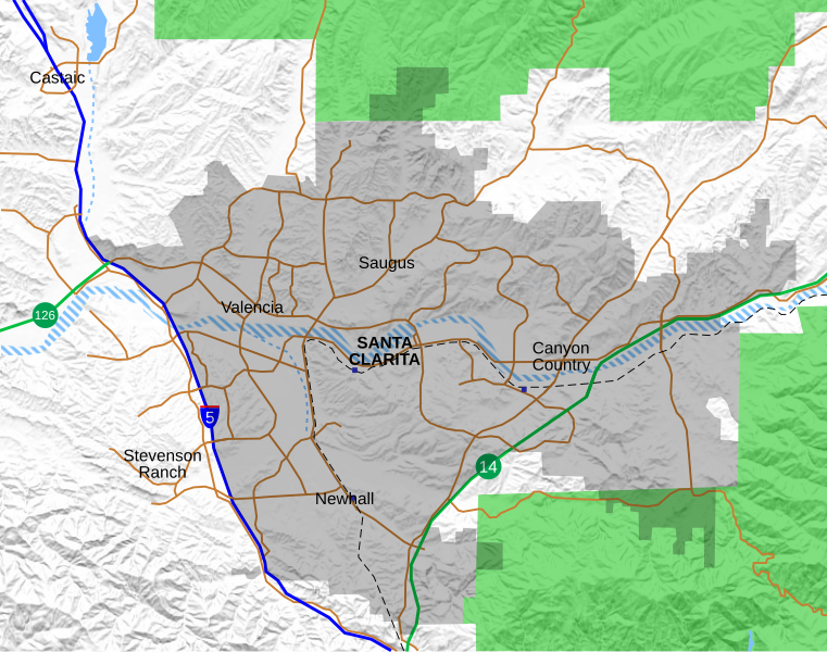
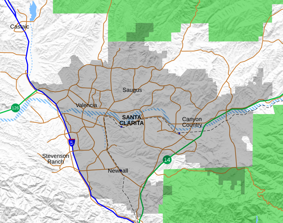
English: Location map for the Santa Clarita Valley in southern California. The scope of the map includes the entire city of Santa Clarita, as well as the nearby unincorporated communities of Stevenson Ranch and part of Castaic.
Legend: Interstate 5
California State Routes (14 and 126)
Major surface streets
Metrolink rail line
Metrolink station (blue boxes)
Santa Clarita city limit (as of 2021)
Permanent bodies of water
Intermittent bodies of water (Santa Clara River and tributaries)
Angeles National Forest |
| 日期 | |
| 来源 | 自己的作品, with data from OpenStreetMap. Shaded relief derived from USGS. |
| 作者 | Crossover1370 |
许可协议
我,本作品著作权人,特此采用以下许可协议发表本作品:
本文件采用知识共享署名-相同方式共享 4.0 国际许可协议授权。
- 您可以自由地:
- 共享 – 复制、发行并传播本作品
- 修改 – 改编作品
- 惟须遵守下列条件:
- 署名 – 您必须对作品进行署名,提供授权条款的链接,并说明是否对原始内容进行了更改。您可以用任何合理的方式来署名,但不得以任何方式表明许可人认可您或您的使用。
- 相同方式共享 – 如果您再混合、转换或者基于本作品进行创作,您必须以与原先许可协议相同或相兼容的许可协议分发您贡献的作品。
文件历史
点击某个日期/时间查看对应时刻的文件。
| 日期/时间 | 缩略图 | 大小 | 用户 | 备注 | |
|---|---|---|---|---|---|
| 当前 | 2021年9月24日 (五) 21:05 | | 796 × 627(1.89 MB) | Crossover1370 | Remove the relatively minor Canyon Park Blvd and Lost Canyon Rd, and add Tourney Rd, a major street home to numerous hotels, government, and medical offices. |
| 2021年9月21日 (二) 21:47 |  | 796 × 627(1.89 MB) | Crossover1370 | A few minor changes involving 3-D placement of certain roads and railroads | |
| 2021年9月20日 (一) 22:56 |  | 796 × 627(1.89 MB) | Crossover1370 | Move the word "Santa Clarita" to top to allow it to be selected like the neighborhood names (no visible difference) | |
| 2021年9月20日 (一) 22:11 |  | 796 × 627(1.89 MB) | Crossover1370 | Sand Canyon Road and Newhall Ranch Road both pass above their respective freeways. Also add Metrolink stations. | |
| 2021年9月20日 (一) 01:15 |  | 796 × 627(1.89 MB) | Crossover1370 | Correct 3D position of streets relative to I-5, rearrange certain objects | |
| 2021年9月19日 (日) 07:01 |  | 796 × 627(1.89 MB) | Crossover1370 | Changed outline of Santa Clarita to shading, add Metrolink train and more streets | |
| 2021年3月26日 (五) 18:31 |  | 797 × 628(1,015 KB) | Crossover1370 | Remove section of Placerita Canyon Road west of Sierra Highway - not a major street. | |
| 2021年3月26日 (五) 01:23 |  | 797 × 628(1,016 KB) | Crossover1370 | Removed some minor streets I added in the previous revision. | |
| 2021年3月25日 (四) 07:11 |  | 797 × 628(1,016 KB) | Crossover1370 | Added more major streets. | |
| 2020年12月23日 (三) 05:10 |  | 797 × 628(1,013 KB) | Crossover1370 | Santa Clara River is still a big black blob. Hopefully this will fix it. |
文件用途
没有页面链接到本图像。
全域文件用途
以下其他wiki使用此文件:
- en.wikipedia.org上的用途
- Valencia, Santa Clarita, California
- The Master's University
- Newhall Pass
- Castaic, California
- Six Flags Magic Mountain
- College of the Canyons
- Stevenson Ranch, California
- Newhall, Santa Clarita, California
- Canyon Country, Santa Clarita, California
- Saugus, Santa Clarita, California
- Golden Oak Ranch
- Castaic Junction, California
- Santa Clarita, California
- Mentryville, California
- Rancho San Francisco
- Newhall incident
- Gibbon Conservation Center
- Placerita Canyon State Park
- Valencia, California
- Lyons Station Stagecoach Stop
- Peter J. Pitchess Detention Center
- Dry Canyon Reservoir
- Sand Canyon, Santa Clarita, California
- User:Crossover1370
- Beale's Cut Stagecoach Pass
- Lang Southern Pacific Station
- Pioneer Oil Refinery
- 2019 Saugus High School shooting
- Valencia Country Club
- Central Park (Santa Clarita)
- Module:Location map/data/Santa Clarita
- Module:Location map/data/Santa Clarita/doc
- Santa Clarita Woodlands Park
- McBean Regional Transit Center
- William S. Hart Regional Park
- fy.wikipedia.org上的用途
- si.wikipedia.org上的用途
- sv.wikipedia.org上的用途