
File:La place du Congrès (Ljubljana) (9374292864).jpg

原始文件 (1,365 × 1,024像素,文件大小:1.46 MB,MIME类型:image/jpeg)
_(9374292864).jpg?uselang=zh)
_(9374292864).jpg?uselang=zh)
_(9374292864).jpg?action=history&uselang=zh)
_(9374292864).jpg)
摘要
| 描述 |
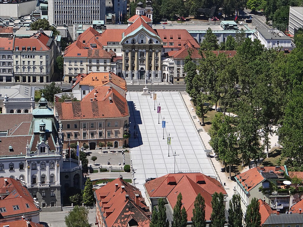
La place du Congrès vue du château de Ljubljana Congress Square / Kongresni trg L'aménagement de la place du Congrès a été conçue par l'architecte Jože Plečnik qui a proposé de la recouvrir de dalles de béton sur sa partie inclinée vers la rivière. Des éléments architecturaux et des candélabres en indiquent l'axe central, les limites et relient les façades des monuments qui la bordent : l'église des Ursulines au fond sur la photo (l'architecte a ajouté un escalier pour la mettre en valeur) et le bâtiment de la Philharmonie qui lui fait face à l'extrémité de la place. A droite, de la place du Congrès, l'architecte Jože Plečnik a également conçu le petit parc. L'aménagement a été réalisé entre 1928 et 1940 Source : Jože Plečnik in Ljubljana and Slovenia, Cankarjeva zolozba - Zaloznistvo d.o.o. Ljubljana, 2007 fr.wikipedia.org/wiki/Jo%C5%BEe_Ple%C4%8Dnik |
| 日期 | |
| 来源 |
La place du Congrès (Ljubljana)
|
| 作者 | dalbera from Paris, France |
| 相机位置 | | 在以下服务上查看本图像和附近其他图像: OpenStreetMap |
|---|
_(9374292864).jpg¶ms=046.049690_N_0014.504452_E_globe:Earth_type:camera_source:Flickr_&language=zh)
许可协议

|
The usage of reproductions of the cultural monuments No. 368 for commercial purposes is restricted by the Slovenian Cultural Heritage Protection Act, which requires a consensus of the owner of the monument for any use of image and name of the monument (article 44). Wikimedia Commons is not required to comply as it is hosted in the United States of America. Users who are citizens of Slovenia are warned that they are solely responsible for any possible violation of local laws. See our general disclaimer for more information. These restrictions are independent of the copyright status of the depicted work.
The definition of a cultural monument is the following (article 3): heritage, which has been statutorily protected as a monument or entered in the inventory of an authorised museum. As much as it concerns immovable cultural heritage, the national catalog is publicly accessible at gisportal.gov.si.
|
| 此张图片原发布于Flickr,在2013年7月28日由管理员或审查员File Upload Bot (Magnus Manske)检查后,确认检查时图片在Flickr的版权声明与维基共享资源的版权使用方针相符。 |
文件历史
点击某个日期/时间查看对应时刻的文件。
| 日期/时间 | 缩略图 | 大小 | 用户 | 备注 | |
|---|---|---|---|---|---|
| 当前 | 2013年7月28日 (日) 10:26 | | 1,365 × 1,024(1.46 MB) | File Upload Bot (Magnus Manske) | Transferred from Flickr by User:sporti |
文件用途
以下页面使用本文件:
全域文件用途
以下其他wiki使用此文件:
- arz.wikipedia.org上的用途
- de.wikipedia.org上的用途
- en.wikivoyage.org上的用途
- he.wikivoyage.org上的用途
- it.wikivoyage.org上的用途
- sl.wikipedia.org上的用途
- www.wikidata.org上的用途
_(9374292864).jpg)