
File:LIRR map.svg

此SVG文件的PNG预览的大小:512 × 304像素。 其他分辨率:320 × 190像素 | 640 × 380像素 | 1,024 × 608像素 | 1,280 × 760像素 | 2,560 × 1,520像素。
原始文件 (SVG文件,尺寸为512 × 304像素,文件大小:370 KB)
摘要
| 描述 |
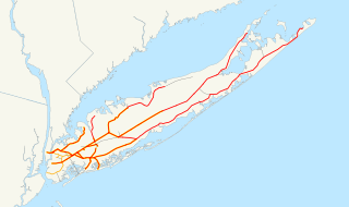
English: This is a map of the rail network currently owned by the Long Island Rail Road. Orange lines are freight-only, and are operated by the New York and Atlantic Railway. Thin black lines have been abandoned. A yellow highlight indicates electrification.
The following GIS data was used:
Deutsch: Karte des Streckennetzes der Long Island Rail Road auf der gleichnamigen Insel.
|
| 日期 | 2006年12月13日 (原始上传日期) |
| 来源 | 无法识别来源。根据版权声明推断为其自己的作品。 |
| 作者 | 无法识别作者。根据版权声明推断作者为NE2。 |
许可协议
| 我,本作品著作权人,释出本作品至公有领域。这适用于全世界。 在一些国家这可能不合法;如果是这样的话,那么: 我无条件地授予任何人以任何目的使用本作品的权利,除非这些条件是法律规定所必需的。 |
文件历史
点击某个日期/时间查看对应时刻的文件。
| 日期/时间 | 缩略图 | 大小 | 用户 | 备注 | |
|---|---|---|---|---|---|
| 当前 | 2017年4月9日 (日) 22:55 | | 512 × 304(370 KB) | Train2104 | Lower Montauk freight only |
| 2007年1月23日 (二) 05:11 |  | 1,152 × 684(583 KB) | NE2 | Changed the orange. | |
| 2007年1月23日 (二) 05:05 |  | 1,152 × 684(583 KB) | NE2 | Made the black grayer. | |
| 2007年1月23日 (二) 05:03 |  | 1,152 × 684(583 KB) | NE2 | Added a few features. | |
| 2006年12月13日 (三) 10:34 |  | 1,152 × 684(517 KB) | NE2 | This is a map of the rail network currentl[y owned by the Long Island Rail Road. Orange lines are freight-only, and are operated by the New York and Atlantic Railway. The following GIS data was used: *[http://www.bts.gov/publications/north_american_trans |
文件用途
以下页面使用本文件:
全域文件用途
以下其他wiki使用此文件:
- ceb.wikipedia.org上的用途
- da.wikipedia.org上的用途
- de.wikipedia.org上的用途
- en.wikipedia.org上的用途
- es.wikipedia.org上的用途
- et.wikipedia.org上的用途
- fr.wikipedia.org上的用途
- he.wikivoyage.org上的用途
- id.wikipedia.org上的用途
- it.wikipedia.org上的用途
- ja.wikipedia.org上的用途
- ko.wikipedia.org上的用途
- nl.wikipedia.org上的用途
- no.wikipedia.org上的用途
- oc.wikipedia.org上的用途
- pl.wikipedia.org上的用途
- pt.wikipedia.org上的用途
- ru.wikipedia.org上的用途
- simple.wikipedia.org上的用途
- sv.wikipedia.org上的用途
- www.wikidata.org上的用途