
File:India average annual temperature map en.svg

原始文件 (SVG文件,尺寸为1,639 × 1,852像素,文件大小:366 KB)
| 标题 |
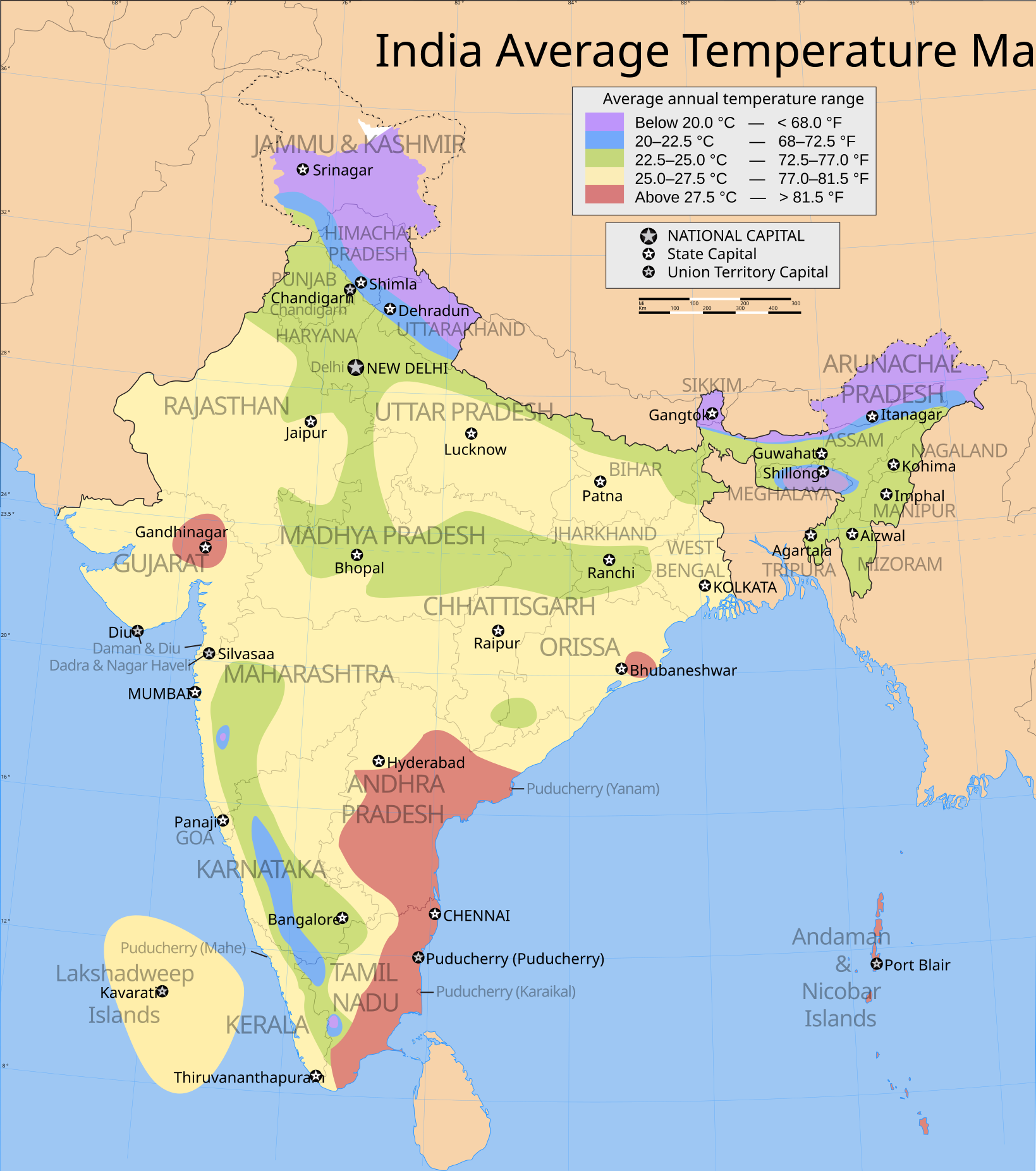
India average annual temperature map english version |
|||||||||
| 描写 |
Map showing zones shaded by average annual temperatures in India |
|||||||||
| 地图图例 |
 |
|||||||||
| 日期 | ||||||||||
| 来源 |
自己的作品 |
|||||||||
| 創作作者 | ||||||||||
| 授权 (二次使用本文件) |
我,本作品著作权人,特此采用以下许可协议发表本作品: 本文件采用知识共享署名-相同方式共享 3.0 未本地化版本许可协议授权。
|
|||||||||
| Geotemporal data | ||||||||||
| 描繪日期 | 20世纪下半期和21世纪 | |||||||||
| 空间参照系统 | conic | |||||||||
| 边框 |
|
|||||||||
| 地理参考 | 如果不适当,请设置 warp_status = skip 为隐藏。 | |||||||||
| Archival data | ||||||||||
| 备注 | Part of WikiProject India Maps | |||||||||

Notes
Depiction of India's borders
- The territorial boundaries of India are shown as per the actual ground situation in accordance with international practices followed by the United Nations ([1], [2]) and the National Geographic Society ([3], [4])
- This map is meant to be for illustrative purpose only and is not authenticated by official government sources. Please check the list of sources and references used to create the map for a measure of accuracy and verifiability.
- The usage of these maps in India, Pakistan and China are governed by different laws that restrict depictions of boundaries other than what is officially recognized by the state. Please check local laws and modify the map accordingly before use.
Explanation of disputed boundaries


- Boundary of Indian claim : The territory India claims is legally theirs, but the claim is disputed by China and Pakistan.
- Line of Control/Line of Conflict : The de facto administrative boundary recognised by the international community. This UN ceasefire line is considered as a temporary solution to an ongoing conflict since the departure of the British Raj.
Borders of disputed regions
The depicted extent of the former territory of the British Indian Empire, succeeded by Republic of India, may not be accepted by few countries as legal due to ongoing border disputes:
- The northern Himalayan region of the disputed territory Indian-administered Kashmir is claimed by India including (Pakistan-administered Kashmir) and the Chinese-occupied territory of (Ladakh plateau). Since 1972, it is divided between all three countries. See also Line of Control and Line of Actual Control.
- Siachen glacier (shown white) is an actively contested region between India and Pakistan. Since 1984, the region is under Indian control.
- The northeastern territory of Arunachal Pradesh is almost entirely claimed by China as part of its Tibetan territory.
- Minor areas of eastern Kashmir's Ladakh division, Himachal Pradesh and Uttarakhand on the Chinese frontier are claimed by China. These areas are under Indian control.
- A small area of Uttarakhand adjoining the Nepal border along the Sarda river is disputed between the two countries.
For a detailed map of all disputed regions in South Asia, see Image:India disputed areas map.svg
Internal borders
The borders of the state of Meghalaya, Assam and Arunachal Pradesh are shown as interpreted from the North-Eastern Areas (Reorganisation) Act, 1971, but has yet to be verified.
Territorial waters
The limit of the territorial waters of India extends to twelve nautical miles measured from the appropriate baseline. See this for more information.
文件历史
点击某个日期/时间查看对应时刻的文件。
| 日期/时间 | 缩略图 | 大小 | 用户 | 备注 | |
|---|---|---|---|---|---|
| 当前 | 2007年7月12日 (四) 02:35 | | 1,639 × 1,852(366 KB) | Abecedare | Uttaranchal -> Uttarakhand; Pondicherry -> Puducherry |
| 2007年3月21日 (三) 04:13 |  | 1,639 × 1,852(366 KB) | Saravask | {{WikiProject_India_Maps |Title=India average annual temperature map english version |Description=Map showing zones shaded by average annual temperatures in India |Source=Traced from [http://www.mapsofindia.com/maps/india/india-map-annualtemperature.jpg i | |
| 2007年3月21日 (三) 02:04 |  | 1,639 × 1,852(366 KB) | Saravask | {{WikiProject_India_Maps |Title=India average annual temperature map english version |Description=Map showing zones shaded by average annual temperatures in India |Source=Traced from [http://www.mapsofindia.com/maps/india/india-map-annualtemperature.jpg i | |
| 2007年3月20日 (二) 16:53 |  | 1,639 × 1,852(366 KB) | Saravask | {{WikiProject_India_Maps |Title=India average annual temperature map english version |Description=Map showing zones shaded by average annual temperatures in India |Source=Traced from [http://www.mapsofindia.com/maps/india/india-map-annualtemperature.jpg i |
文件用途
以下页面使用本文件:
全域文件用途
以下其他wiki使用此文件:
- bh.wikipedia.org上的用途
- en.wikipedia.org上的用途
- fr.wikipedia.org上的用途
- fr.wikinews.org上的用途
- hi.wikipedia.org上的用途
- hu.wikipedia.org上的用途
- it.wikipedia.org上的用途
- it.wikivoyage.org上的用途
- nl.wikipedia.org上的用途
- sl.wikipedia.org上的用途
- sq.wikipedia.org上的用途
- te.wikipedia.org上的用途