
File:Iceland (3), Reykjanes peninsula.JPG

本预览的尺寸:800 × 531像素。 其他分辨率:320 × 213像素 | 640 × 425像素 | 1,024 × 680像素 | 1,280 × 850像素 | 1,716 × 1,140像素。
原始文件 (1,716 × 1,140像素,文件大小:672 KB,MIME类型:image/jpeg)
,_Reykjanes_peninsula.JPG?uselang=zh)
,_Reykjanes_peninsula.JPG?uselang=zh)
,_Reykjanes_peninsula.JPG?action=history&uselang=zh)
,_Reykjanes_peninsula.JPG)
摘要
| 描述 |
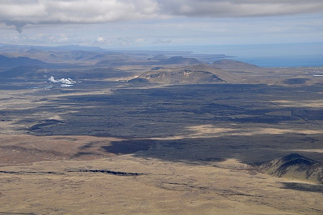
English: The Reykjanes Peninsula in Iceland is mostly a barren waste of lava fields. The steam on the left comes from the geothermal power station at Svartsengi. Surplus mineral rich and hot water from the plant fills up the Blue Lagoon, a tourist bathing resort.
Nederlands: Het schiereiland Reykjanes in IJsland bestaat grotendeels uit lavavelden, vrijwel zonder vegetatie. De stoompluimen (links) zijn afkomstig van de geothermische energiecentrale Svartsengi. Overtollig heet water van de centrale wordt gebruikt voor het nabijgelegen bad "Blue Lagoon", een toeristische trekpleister. |
| 日期 | |
| 来源 | 自己的作品 |
| 作者 | Vincent van Zeijst |
| 相机位置 | | 在以下服务上查看本图像和附近其他图像: OpenStreetMap |
|---|
,_Reykjanes_peninsula.JPG¶ms=063.875761_N_-022.568664_E_globe:Earth_type:camera_region:IS_heading:90.00&language=zh)
Looking East.
许可协议
我,本作品著作权人,特此采用以下许可协议发表本作品:
本文件采用知识共享署名 3.0 未本地化版本许可协议授权。
- 您可以自由地:
- 共享 – 复制、发行并传播本作品
- 修改 – 改编作品
- 惟须遵守下列条件:
- 署名 – 您必须对作品进行署名,提供授权条款的链接,并说明是否对原始内容进行了更改。您可以用任何合理的方式来署名,但不得以任何方式表明许可人认可您或您的使用。
| 註解 | 該圖片含有註解:在維基媒體共享資源上查看註解 |
,_Reykjanes_peninsula.JPG)
文件历史
点击某个日期/时间查看对应时刻的文件。
| 日期/时间 | 缩略图 | 大小 | 用户 | 备注 | |
|---|---|---|---|---|---|
| 当前 | 2011年5月22日 (日) 16:46 | | 1,716 × 1,140(672 KB) | Loranchet | {{Information |Description ={{en|1=The Reykjanes Peninsula in Iceland is mostly a barren waste of lava fields. The steam on the left comes from the geothermal power station at Svartsengi. Surplus mineral rich and hot water from the plant fills up the B |
文件用途
全域文件用途
以下其他wiki使用此文件:
- ar.wikipedia.org上的用途
- az.wikipedia.org上的用途
- ca.wikipedia.org上的用途
- ceb.wikipedia.org上的用途
- cs.wikipedia.org上的用途
- de.wikipedia.org上的用途
- en.wikipedia.org上的用途
- en.wikivoyage.org上的用途
- eo.wikipedia.org上的用途
- es.wikipedia.org上的用途
- eu.wikipedia.org上的用途
- fa.wikipedia.org上的用途
- fr.wikipedia.org上的用途
- ga.wikipedia.org上的用途
- gd.wikipedia.org上的用途
- gl.wikipedia.org上的用途
- he.wikipedia.org上的用途
- hy.wikipedia.org上的用途
- id.wikipedia.org上的用途
- it.wikipedia.org上的用途
- ja.wikipedia.org上的用途
- ka.wikipedia.org上的用途
- ko.wikipedia.org上的用途
- mk.wikipedia.org上的用途
- ml.wikipedia.org上的用途
- nl.wikipedia.org上的用途
- no.wikipedia.org上的用途
- os.wikipedia.org上的用途
- pl.wikipedia.org上的用途
- pnb.wikipedia.org上的用途
- pt.wikipedia.org上的用途
- ru.wikipedia.org上的用途
- sh.wikipedia.org上的用途
- uk.wikipedia.org上的用途
- vls.wikipedia.org上的用途
- www.wikidata.org上的用途
查看本文件的更多全域用途。
,_Reykjanes_peninsula.JPG)
,_Reykjanes_peninsula.JPG)