
File:Houston Downtown Map.png
本预览的尺寸:600 × 599像素。 其他分辨率:240 × 240像素 | 481 × 480像素 | 698 × 697像素。
原始文件 (698 × 697像素,文件大小:519 KB,MIME类型:image/png)
摘要
| 描述 |
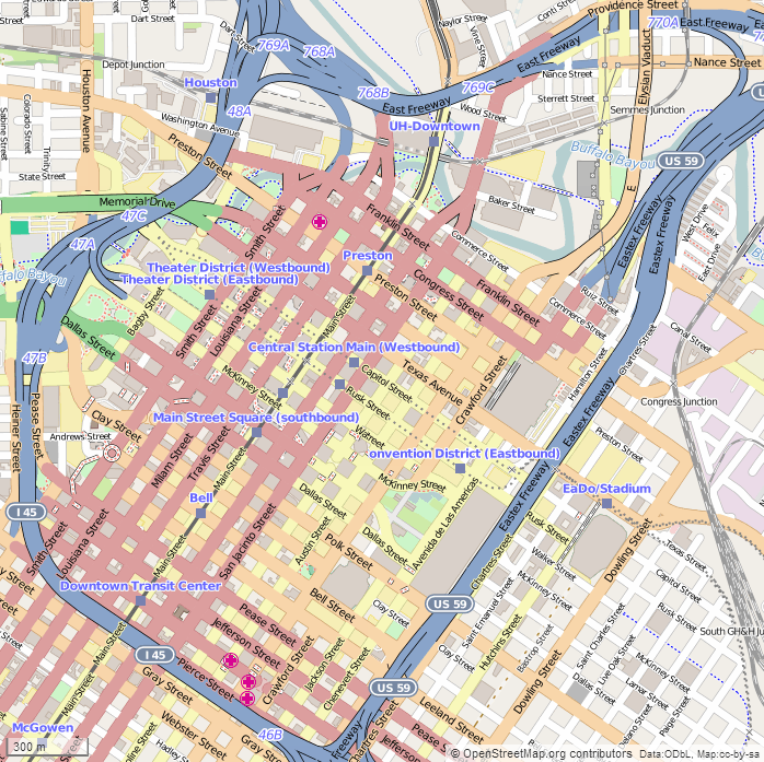
English: This map of Downtown Houston was created from OpenStreetMap project data, collected by the community. The image should remain clear of any additional edits. To annotate the map for an article, use the Infobox or Location Map template and reference the map using map module Houston Downtown. This map may be incomplete, and may contain errors. Submit corrections to the below source link. Do not rely solely on the map for navigation. Steven Driskell
|
| 日期 | |
| 来源 | http://www.openstreetmap.org |
| 作者 | OpenStreetMap contributors |
许可协议
本文件采用知识共享署名-相同方式共享 2.5 通用许可协议授权。
- 您可以自由地:
- 共享 – 复制、发行并传播本作品
- 修改 – 改编作品
- 惟须遵守下列条件:
- 署名 – 您必须对作品进行署名,提供授权条款的链接,并说明是否对原始内容进行了更改。您可以用任何合理的方式来署名,但不得以任何方式表明许可人认可您或您的使用。
- 相同方式共享 – 如果您再混合、转换或者基于本作品进行创作,您必须以与原先许可协议相同或相兼容的许可协议分发您贡献的作品。
文件历史
点击某个日期/时间查看对应时刻的文件。
| 日期/时间 | 缩略图 | 大小 | 用户 | 备注 | |
|---|---|---|---|---|---|
| 当前 | 2015年2月16日 (一) 22:35 | | 698 × 697(519 KB) | SDriskell | User created page with UploadWizard |
文件用途
以下页面使用本文件:
全域文件用途
以下其他wiki使用此文件:
- ar.wikipedia.org上的用途
- en.wikipedia.org上的用途
- Minute Maid Park
- Toyota Center
- Downtown Houston
- Christ Church Cathedral (Houston)
- Wortham Theater Center
- Houston Theater District
- Jones Hall
- The Rice (Houston)
- Club Quarters Hotel (Houston)
- Shell Energy Stadium
- Julia Ideson Building
- The Sam Houston Hotel
- Merchants and Manufacturers Building
- Main Street Market Square Historic District
- United States Customhouse (Houston)
- Annunciation Church (Houston)
- Beaconsfield (Houston)
- Houston Cotton Exchange Building
- Hogg Building
- W. L. Foley Building
- Humble Oil Building
- Union Station (Houston)
- St. Joseph Medical Center (Houston)
- Sweeney, Coombs, and Fredericks Building
- JW Marriott Downtown Houston
- Kennedy Bakery
- McKee Street Bridge
- Pillot Building
- Texas Company Building
- Paul Building
- Palace Hotel (Houston)
- National Biscuit Company Building (Houston)
- S. H. Kress and Co. Building (Houston)
- Houston Post-Dispatch Building
- Scanlan Building
- South Texas National Bank (Houston)
- State National Bank Building (Houston, Texas)
- James Bute Company Warehouse
- City National Bank Building (Houston)
- Module:Location map/data/USA Texas Houston downtown
- San Jacinto Street Bridge over Buffalo Bayou
- Stowers Building
- Arthur B. Cohn House
- 1910 Harris County Courthouse
- Module:Location map/data/USA Texas Houston downtown/doc
- Battelstein's
- es.wikipedia.org上的用途
- fa.wikipedia.org上的用途
查看此文件的更多全域用途。